Géolocaliser

Carte topographique Braid Hill

Cliquez sur la carte pour afficher l’altitude.

À propos de cette carte

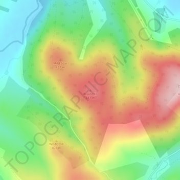
Nom : Carte topographique Braid Hill, altitude, relief.

Lieu : Braid Hill, South Lanarkshire, Scotland, ML12 6SH, United Kingdom (55.47870 -3.75644 55.47880 -3.75634)

Altitude moyenne : 353 m

Altitude minimum : 249 m

Altitude maximum : 480 m

Autres cartes topographiques

Cliquez sur une carte pour visualiser sa topographie, son altitude et son relief.

Skye

United Kingdom > Scotland > Highland

Beyond Loch Snizort to the west of Trotternish is the Waternish peninsula, which ends in Ardmore Point's double rock arch. Duirinish peninsula is separated from Waternish by Loch Dunvegan, which contains the island of Isay. It is ringed by sea cliffs that reach 296 metres (971 feet) on the west at Waterstein…

Altitude moyenne : 63 m

City of Edinburgh

United Kingdom > Scotland

Edinburgh has been popularly called the Athens of the North since the early 19th century. References to Athens, such as Athens of Britain and Modern Athens, had been made as early as the 1760s. The similarities were seen to be topographical but also intellectual. Edinburgh's Castle Rock reminded returning…

Altitude moyenne : 118 m

Lewis and Harris

United Kingdom > Scotland

Altitude moyenne : 28 m

Dunfermline

United Kingdom > Scotland > Fife > Dunfermline

Altitude moyenne : 80 m

Glasgow City

United Kingdom > Scotland

Altitude moyenne : 64 m

Moray

United Kingdom > Scotland

Altitude moyenne : 280 m

Aberdeen City

United Kingdom > Scotland

Two weather stations collect climate data for the area, Aberdeen/Dyce Airport, and Craibstone. Both are about 4+1⁄2 miles (7 km) to the north west of the city centre, and given that they are in close proximity to each other, exhibit very similar climatic regimes. Dyce tends to have marginally warmer daytime…

Altitude moyenne : 46 m

Dumfries and Galloway

United Kingdom > Scotland

Altitude moyenne : 163 m

Leith Links

United Kingdom > Scotland > Edinburgh

Altitude moyenne : 15 m

Applecross

United Kingdom > Scotland > Highland

Altitude moyenne : 149 m

Dunfermline

United Kingdom > Scotland > Fife

Altitude moyenne : 114 m

Skara Brae

United Kingdom > Scotland > Orkney Islands

Altitude moyenne : 15 m

Moray

United Kingdom > Scotland

Altitude moyenne : 281 m

Orkney Islands

United Kingdom > Scotland

The southern group of islands surrounds Scapa Flow. Hoy, to the west, is the second largest of the Orkney Isles and Ward Hill at its northern end is the highest elevation in the archipelago. The Old Man of Hoy is a well-known seastack. Graemsay and Flotta are both linked by ferry to the Mainland and Hoy, and…

Altitude moyenne : 7 m

Highland

United Kingdom > Scotland

Altitude moyenne : 183 m

Perth and Kinross

United Kingdom > Scotland

Altitude moyenne : 338 m

Quiraing

United Kingdom > Scotland > Highland

Altitude moyenne : 298 m

Scottish Borders

United Kingdom > Scotland

Altitude moyenne : 257 m

Loch Lomond and The Trossachs National Park

United Kingdom > Scotland > Stirling

The park straddles the Highland Boundary Fault, which divides it into two distinct regions - lowland and highland - that differ in underlying geology, soil types and topography. The change in rock type can most clearly be seen at Loch Lomond itself, as the fault runs across the islands of Inchmurrin, Creinch,…

Altitude moyenne : 291 m

Isle of Rum

United Kingdom > Scotland > Highland > Kinloch

The island's relief is spectacular, a 19th-century commentator remarking that "the interior is one heap of rude mountains, scarcely possessing an acre of level land". This combination of geology and topography make for less than ideal agricultural conditions, and it is doubtful that more than one tenth of the…

Altitude moyenne : 118 m

Sanday

United Kingdom > Scotland > Orkney Islands > Kettletoft

In the mid-17th century an annexe to Blaeu's Atlas Novus of Scotland recorded that Sanday's low lying topography meant that "shipwreck often occurs to those who sail there at night. The inhabitants of Sanday earnestly and often desire this to happen, so that they get a supply of material for fire from the…

Altitude moyenne : 2 m

Northfield

United Kingdom > Scotland > Aberdeen City

Altitude moyenne : 91 m

Shetland

United Kingdom > Scotland

Walter Scott's 1822 novel The Pirate is set in "a remote part of Shetland", and was inspired by his 1814 visit to the islands. The name Jarlshof meaning "Earl's Mansion" is a coinage of his. Robert Cowie, a doctor born in Lerwick published the 1874 work.Shetland: Descriptive and Historical; Being a Graduation…

Altitude moyenne : 4 m

Hebrides

United Kingdom > Scotland

Altitude moyenne : 94 m

Fife

United Kingdom > Scotland

Altitude moyenne : 67 m

Midlothian

United Kingdom > Scotland

Altitude moyenne : 236 m

North Lanarkshire

United Kingdom > Scotland

Altitude moyenne : 149 m

South Lanarkshire

United Kingdom > Scotland

Altitude moyenne : 289 m

Angus

United Kingdom > Scotland

Angus can be split into three geographic areas. To the north and west, the topography is mountainous. This is the area of the Grampian Mountains, Mounth hills and Five Glens of Angus, which is sparsely populated and where the main industry is hill farming. Glas Maol – the highest point in Angus at 1,068 m…

Altitude moyenne : 254 m

West Lothian

United Kingdom > Scotland

Altitude moyenne : 184 m

East Lothian

United Kingdom > Scotland

Altitude moyenne : 132 m

Dundee City

United Kingdom > Scotland

Altitude moyenne : 74 m

Argyll and Bute

United Kingdom > Scotland

Altitude moyenne : 84 m

Caithness

United Kingdom > Scotland

Caithness extends about 30 miles (48 km) north-south and about 30 miles (48 km) east-west, with a roughly triangular-shaped area of about 712 sq mi (1,840 km2). The topography is generally flat, in contrast to the majority of the remainder of the North of Scotland. Until the latter part of the 20th century…

Altitude moyenne : 79 m

South Ayrshire

United Kingdom > Scotland

The number of hours of natural sunshine in South Ayrshire is controlled by the length of day and by cloudiness. In general, December is the dullest month and May or June the sunniest. Sunshine duration decreases with increasing altitude, increasing latitude and distance from the coast. Local topography also…

Altitude moyenne : 151 m

Renfrewshire

United Kingdom > Scotland

Altitude moyenne : 104 m

Aberdeenshire

United Kingdom > Scotland

Altitude moyenne : 199 m

North Ayrshire

United Kingdom > Scotland

Altitude moyenne : 80 m

East Ayrshire

United Kingdom > Scotland

East Ayrshire is located on the west coat of Scotland, sharing borders with the following neighbouring council areas; North Ayrshire, South Ayrshire, Dumfries and Galloway, East Renfrewshire and South Lanarkshire. Blackcraig Hill reaches an elevation of 2,298 feet (700 metres), the highest peak in East…

Altitude moyenne : 225 m

South Queensferry

United Kingdom > Scotland

Altitude moyenne : 31 m

River Tweed

United Kingdom > Scotland

Altitude moyenne : 236 m

River Clyde

United Kingdom > Scotland

Altitude moyenne : 245 m

Inchmickery

United Kingdom > Scotland

Altitude moyenne : 0 m

Ailsa Craig

United Kingdom > Scotland

In a small glen above Ailsa Castle, a small freshwater body known as the Garry Loch is located at an altitude of 247 m (810 ft), with a depth of at least 17 feet.

Altitude moyenne : 14 m

Iona

United Kingdom > Scotland

Altitude moyenne : 9 m

Glen Dochart

United Kingdom > Scotland

Altitude moyenne : 469 m

Falkirk

United Kingdom > Scotland

Altitude moyenne : 105 m

Denton Burn

United Kingdom > Scotland

Altitude moyenne : 154 m

Taynish Island

United Kingdom > Scotland

Altitude moyenne : 11 m

River Kerry

United Kingdom > Scotland

Altitude moyenne : 118 m

Abhainn a' Ghlinne Ghil

United Kingdom > Scotland

Altitude moyenne : 138 m

River Dee

United Kingdom > Scotland

Altitude moyenne : 299 m

River Don

United Kingdom > Scotland

Altitude moyenne : 257 m

Papa

United Kingdom > Scotland

Altitude moyenne : 2 m

Loch Urigill

United Kingdom > Scotland

Altitude moyenne : 172 m

Highland

United Kingdom > Scotland

Altitude moyenne : 402 m

Rogart

United Kingdom > Scotland > Highland

Altitude moyenne : 236 m

Snap

United Kingdom > Scotland

Altitude moyenne : 3 m

Stirling

United Kingdom > Scotland

Altitude moyenne : 293 m

East Dunbartonshire

United Kingdom > Scotland

Altitude moyenne : 161 m

West Dunbartonshire

United Kingdom > Scotland

Altitude moyenne : 101 m

Clackmannanshire

United Kingdom > Scotland

Altitude moyenne : 175 m

Western Isles

United Kingdom > Scotland

Altitude moyenne : 57 m

East Renfrewshire

United Kingdom > Scotland

Altitude moyenne : 163 m

Inverclyde

United Kingdom > Scotland

Altitude moyenne : 141 m

River Spey

United Kingdom > Scotland

Altitude moyenne : 336 m

Sea of the Hebrides

United Kingdom > Scotland

Altitude moyenne : 18 m

The Minch

United Kingdom > Scotland

Altitude moyenne : 63 m

St Magnus' Bay

United Kingdom > Scotland

Altitude moyenne : 6 m

Hirta

United Kingdom > Scotland > Western Isles

Altitude moyenne : 58 m

Isle of Arran

United Kingdom > Scotland > North Ayrshire

The island has three endemic species of tree, the Arran whitebeams. These trees are the Scottish or Arran whitebeam (Sorbus arranensis), the bastard mountain ash or cut-leaved whitebeam (Sorbus pseudofennica) and the Catacol whitebeam (Sorbus pseudomeinichii). If rarity is measured by numbers alone they are…

Altitude moyenne : 98 m

Mull

United Kingdom > Scotland > Argyll and Bute

Altitude moyenne : 122 m

Awe Barrage

United Kingdom > Scotland > Argyll and Bute

Altitude moyenne : 263 m

Old Town

United Kingdom > Scotland > City of Edinburgh

Altitude moyenne : 61 m

East Kilbride

United Kingdom > Scotland > East Kilbride

Altitude moyenne : 177 m

Loch Fannich

United Kingdom > Scotland > Highland

Altitude moyenne : 463 m

the Black Isle

United Kingdom > Scotland > Highland

Altitude moyenne : 82 m

Erchless Castle

United Kingdom > Scotland > Highland > Struy

Altitude moyenne : 131 m

Glen Lethnot

United Kingdom > Scotland > Angus

Altitude moyenne : 365 m

Aberdour

United Kingdom > Scotland > Fife

Altitude moyenne : 77 m

Falahill

United Kingdom > Scotland > Scottish Borders

Altitude moyenne : 307 m

Glen Lyon

United Kingdom > Scotland > Perth and Kinross

Altitude moyenne : 461 m

Whitebridge

United Kingdom > Scotland > Highland

Altitude moyenne : 223 m

Knoydart

United Kingdom > Scotland > Highland > Inverie

Altitude moyenne : 216 m

Loch Brandy

United Kingdom > Scotland > Angus

Altitude moyenne : 691 m

Achray Water

United Kingdom > Scotland > Stirling

Altitude moyenne : 167 m

Scapa Flow

United Kingdom > Scotland > Orkney Islands

Altitude moyenne : 14 m

Loch Ardinning

United Kingdom > Scotland > Stirling > Mugdock

Altitude moyenne : 136 m

Thurso

United Kingdom > Scotland > Highland

Altitude moyenne : 25 m

Currie

United Kingdom > Scotland > City of Edinburgh

The period 1921-1951 brought great changes with the building of more council houses in Currie and private building along Lanark Road. Wider scale development began in the late 1950s and early 1960s with the construction of a private housing estate to the east of Curriehill Road. House builders began to promote…

Altitude moyenne : 163 m

Équipez-vous pour votre prochaine aventure :

🥾Chaussures de marche Homme - Maintien et imperméabilité pour les sentiers techniques suisses
Piquets de tente légers - Solidité et légèreté pour remplacer vos piquets d'origine
🪜Bâtons de marche - Bâtons télescopiques pour stabilité et endurance
🧦Chaussettes mérinos - Confort thermique longue durée
Tasse de randonnée - Légère et robuste pour votre pause café face au panorama

En tant que Partenaire Amazon, ce site perçoit une commission sur les achats éligibles sans surcoût pour vous.