Géolocaliser

Carte topographique Falahill

Cliquez sur la carte pour afficher l’altitude.

À propos de cette carte

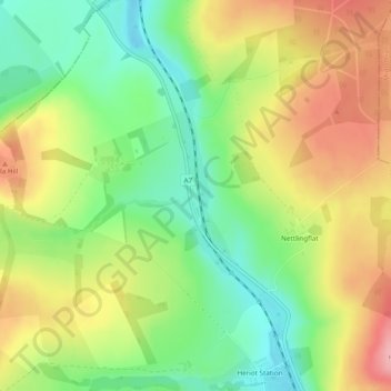
Nom : Carte topographique Falahill, altitude, relief.

Lieu : Falahill, Scottish Borders, Scotland, EH38 5YG, United Kingdom (55.79120 -2.96431 55.79290 -2.96299)

Altitude moyenne : 307 m

Altitude minimum : 250 m

Altitude maximum : 375 m

Autres cartes topographiques

Cliquez sur une carte pour visualiser sa topographie, son altitude et son relief.

Jedburgh

United Kingdom > Scotland > Scottish Borders

Altitude moyenne : 151 m

Peebles

United Kingdom > Scotland > Scottish Borders

Altitude moyenne : 275 m

Hawick

United Kingdom > Scotland > Scottish Borders

Altitude moyenne : 199 m

Earlston

United Kingdom > Scotland > Scottish Borders

Altitude moyenne : 169 m

Blythe

United Kingdom > Scotland > Scottish Borders

Altitude moyenne : 255 m

Selkirk

United Kingdom > Scotland > Scottish Borders

Altitude moyenne : 226 m

Penchrise Pen

United Kingdom > Scotland > Scottish Borders

Altitude moyenne : 304 m

Wilson's Pike

United Kingdom > Scotland > Scottish Borders

Altitude moyenne : 362 m

Auchencrow

United Kingdom > Scotland > Scottish Borders

Altitude moyenne : 120 m

Newcastleton

United Kingdom > Scotland > Scottish Borders

Altitude moyenne : 164 m

Carlavin Hill

United Kingdom > Scotland > Scottish Borders

Altitude moyenne : 557 m

Middlethird

United Kingdom > Scotland > Scottish Borders

Altitude moyenne : 157 m

Frogden

United Kingdom > Scotland > Scottish Borders

Altitude moyenne : 132 m

Wood Head

United Kingdom > Scotland > Scottish Borders

Altitude moyenne : 129 m

Longformacus

United Kingdom > Scotland > Scottish Borders

Altitude moyenne : 242 m

Hownam

United Kingdom > Scotland > Scottish Borders

Altitude moyenne : 234 m

Honeyburn

United Kingdom > Scotland > Scottish Borders > Denholm

Altitude moyenne : 131 m

Heugh Head

United Kingdom > Scotland > Scottish Borders > Reston

Altitude moyenne : 111 m

Furlongs

United Kingdom > Scotland > Scottish Borders > Ancrum

Altitude moyenne : 108 m

Oxnam

United Kingdom > Scotland > Scottish Borders

Altitude moyenne : 171 m

Saughtree

United Kingdom > Scotland > Scottish Borders

Altitude moyenne : 266 m

Harlaw

United Kingdom > Scotland > Scottish Borders

Altitude moyenne : 83 m

Eyemouth

United Kingdom > Scotland > Scottish Borders

Altitude moyenne : 31 m

Redpath

United Kingdom > Scotland > Scottish Borders

Altitude moyenne : 253 m

Scabcleuch

United Kingdom > Scotland > Scottish Borders

Altitude moyenne : 403 m

St. Abbs

United Kingdom > Scotland > Scottish Borders

Altitude moyenne : 36 m

Innerleithen

United Kingdom > Scotland > Scottish Borders

Altitude moyenne : 293 m

Fans

United Kingdom > Scotland > Scottish Borders

Altitude moyenne : 158 m

Harelaw

United Kingdom > Scotland > Scottish Borders > Chirnside

Altitude moyenne : 90 m

Eshiels

United Kingdom > Scotland > Scottish Borders > Peebles

Altitude moyenne : 235 m

Duddy Bank

United Kingdom > Scotland > Scottish Borders

Altitude moyenne : 367 m

Oxenrig

United Kingdom > Scotland > Scottish Borders > Coldstream

Altitude moyenne : 43 m

Teviothead

United Kingdom > Scotland > Scottish Borders

Altitude moyenne : 252 m

Traquair

United Kingdom > Scotland > Scottish Borders

Altitude moyenne : 247 m

Preston

United Kingdom > Scotland > Scottish Borders

Altitude moyenne : 132 m

Carlops

United Kingdom > Scotland > Scottish Borders

Altitude moyenne : 340 m

Newstead

United Kingdom > Scotland > Scottish Borders

Altitude moyenne : 157 m

Fogomoor

United Kingdom > Scotland > Scottish Borders > Fogo

Altitude moyenne : 119 m

Bridgend

United Kingdom > Scotland > Scottish Borders > Tweedbank

Altitude moyenne : 157 m

Darnick

United Kingdom > Scotland > Scottish Borders

Altitude moyenne : 160 m

West Linton

United Kingdom > Scotland > Scottish Borders

Altitude moyenne : 264 m

Ashkirk

United Kingdom > Scotland > Scottish Borders

Altitude moyenne : 238 m

Crailing

United Kingdom > Scotland > Scottish Borders

Altitude moyenne : 92 m

Gordon

United Kingdom > Scotland > Scottish Borders

Altitude moyenne : 159 m

Knock Hill

United Kingdom > Scotland > Scottish Borders

Altitude moyenne : 279 m

Ramseycleuch

United Kingdom > Scotland > Scottish Borders > Ettrick

Altitude moyenne : 364 m

Dewar Hill

United Kingdom > Scotland > Scottish Borders

Altitude moyenne : 459 m

Minto

United Kingdom > Scotland > Scottish Borders

Altitude moyenne : 131 m

Tweedsmuir

United Kingdom > Scotland > Scottish Borders

Altitude moyenne : 346 m

Crossrig

United Kingdom > Scotland > Scottish Borders

Altitude moyenne : 60 m

Skirling

United Kingdom > Scotland > Scottish Borders

Altitude moyenne : 249 m

Coldstream

United Kingdom > Scotland > Scottish Borders

Altitude moyenne : 52 m

Ednam

United Kingdom > Scotland > Scottish Borders

Altitude moyenne : 56 m

Stichill

United Kingdom > Scotland > Scottish Borders

Altitude moyenne : 100 m

Springwells

United Kingdom > Scotland > Scottish Borders

Altitude moyenne : 79 m

Blyth Bridge

United Kingdom > Scotland > Scottish Borders

Altitude moyenne : 252 m

Timpendean

United Kingdom > Scotland > Scottish Borders > Jedburgh

Altitude moyenne : 112 m

Broughton

United Kingdom > Scotland > Scottish Borders

Altitude moyenne : 268 m

Morebattle

United Kingdom > Scotland > Scottish Borders

Altitude moyenne : 127 m

Teviothead

United Kingdom > Scotland > Scottish Borders

Altitude moyenne : 252 m

Selkirk

United Kingdom > Scotland > Scottish Borders

Altitude moyenne : 226 m

Kelso

United Kingdom > Scotland > Scottish Borders

Altitude moyenne : 79 m

Black Hill

United Kingdom > Scotland > Scottish Borders

Altitude moyenne : 273 m

Earnslaw

United Kingdom > Scotland > Scottish Borders

Altitude moyenne : 68 m

Roxburgh

United Kingdom > Scotland > Scottish Borders

Altitude moyenne : 82 m

Kilbucho

United Kingdom > Scotland > Scottish Borders

Altitude moyenne : 269 m

Darny Rig

United Kingdom > Scotland > Scottish Borders

Altitude moyenne : 326 m

Legerwood

United Kingdom > Scotland > Scottish Borders

Altitude moyenne : 212 m

Abbey St. Bathans

United Kingdom > Scotland > Scottish Borders

Abbey St Bathans (Scottish Gaelic: Abaid Bhaoithin) is a parish in the Lammermuir district of Berwickshire, in the eastern part of the Scottish Borders. Unique in its topography, it is situated in a long winding steep wooded valley that follows the Whiteadder Water. The parish had a population of 106 at the…

Altitude moyenne : 212 m

Rubers Law

United Kingdom > Scotland > Scottish Borders

Altitude moyenne : 229 m

Burnet Knowe

United Kingdom > Scotland > Scottish Borders > Hownam

Altitude moyenne : 218 m

Fens

United Kingdom > Scotland > Scottish Borders > St Boswells

Altitude moyenne : 96 m

Chirnside

United Kingdom > Scotland > Scottish Borders

Altitude moyenne : 80 m

Greenlaw

United Kingdom > Scotland > Scottish Borders

Altitude moyenne : 179 m

East Middle

United Kingdom > Scotland > Scottish Borders

Altitude moyenne : 156 m

Lyne

United Kingdom > Scotland > Scottish Borders

Altitude moyenne : 239 m

Graden

United Kingdom > Scotland > Scottish Borders

Altitude moyenne : 177 m

Charterhall

United Kingdom > Scotland > Scottish Borders

Altitude moyenne : 117 m

Penmanshiel

United Kingdom > Scotland > Scottish Borders

Altitude moyenne : 179 m

Eddleston

United Kingdom > Scotland > Scottish Borders

Altitude moyenne : 282 m

Muirfield

United Kingdom > Scotland > Scottish Borders

Altitude moyenne : 227 m

Denholm

United Kingdom > Scotland > Scottish Borders

In Main Street, stands The Text House, a category B listed building, erected about 1910 by John Haddon (1845–1924), a medical doctor and author of published works on public sanitation and dietetics. The 3-storey house is in the arts and craft style. One of the texts on the front elevation is a reminder to…

Altitude moyenne : 128 m

Hopehouse

United Kingdom > Scotland > Scottish Borders

Altitude moyenne : 321 m

Clerklands

United Kingdom > Scotland > Scottish Borders

Altitude moyenne : 212 m

Steele Road

United Kingdom > Scotland > Scottish Borders

Altitude moyenne : 185 m

Cringletie

United Kingdom > Scotland > Scottish Borders

Altitude moyenne : 257 m

Galashiels

United Kingdom > Scotland > Scottish Borders

Altitude moyenne : 220 m

Kelso

United Kingdom > Scotland > Scottish Borders

Altitude moyenne : 79 m

Hawick

United Kingdom > Scotland > Scottish Borders

Altitude moyenne : 199 m

Fens

United Kingdom > Scotland > Scottish Borders > St Boswells

Altitude moyenne : 96 m

Équipez-vous pour votre prochaine aventure :

🔋Piles rechargeables - Économiques et écologiques pour vos appareils nomades
🧦Chaussettes de randonnée - Conception technique pour éviter les ampoules sur les longs dénivelés
🍽️Popotes de camping - Ustensiles légers pour repas en bivouac
🦯Bâtons de marche - Réduisez la fatigue musculaire lors des fortes pentes et descentes
🎒Housse de sac à dos - Protection supplémentaire pour garder vos affaires au sec

En tant que Partenaire Amazon, ce site perçoit une commission sur les achats éligibles sans surcoût pour vous.