
Faire un don
Équipez-vous pour votre prochaine aventure :
En tant que Partenaire Amazon, ce site perçoit une commission sur les achats éligibles sans surcoût pour vous.
Carte topographique Denholm
Cliquez sur la carte pour afficher l’altitude.
Faire un don
Équipez-vous pour votre prochaine aventure :
En tant que Partenaire Amazon, ce site perçoit une commission sur les achats éligibles sans surcoût pour vous.
Denholm
In Main Street, stands The Text House, a category B listed building, erected about 1910 by John Haddon (1845–1924), a medical doctor and author of published works on public sanitation and dietetics. The 3-storey house is in the arts and craft style. One of the texts on the front elevation is a reminder to take care with time before it passes, "TAK TENT IN TIME ~ ERE TIME BE TINT", the other text reminds the occupier that there were and will be others living in the house, "ALL WAS OTHERS ~ ALL WILL BE OTHERS".
Faire un don
Équipez-vous pour votre prochaine aventure :
En tant que Partenaire Amazon, ce site perçoit une commission sur les achats éligibles sans surcoût pour vous.
À propos de cette carte
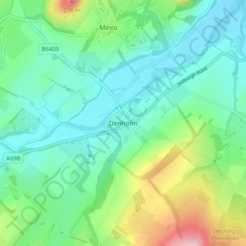
Nom : Carte topographique Denholm, altitude, relief.
Lieu : Denholm, Scottish Borders, Scotland, TD9 8NU, United Kingdom (55.43804 -2.70362 55.47804 -2.66362)
Altitude moyenne : 128 m
Altitude minimum : 65 m
Altitude maximum : 307 m
Faire un don
Équipez-vous pour votre prochaine aventure :
En tant que Partenaire Amazon, ce site perçoit une commission sur les achats éligibles sans surcoût pour vous.
Autres cartes topographiques
Cliquez sur une carte pour visualiser sa topographie, son altitude et son relief.
Faire un don
Équipez-vous pour votre prochaine aventure :
En tant que Partenaire Amazon, ce site perçoit une commission sur les achats éligibles sans surcoût pour vous.
Greenknowe Tower
United Kingdom > Scotland > Scottish Borders > Gordon > Nether Huntlywood
Altitude moyenne : 157 m
Faire un don
Équipez-vous pour votre prochaine aventure :
En tant que Partenaire Amazon, ce site perçoit une commission sur les achats éligibles sans surcoût pour vous.
Faire un don
Équipez-vous pour votre prochaine aventure :
En tant que Partenaire Amazon, ce site perçoit une commission sur les achats éligibles sans surcoût pour vous.
Moffat Hills
United Kingdom > Scotland > Scottish Borders > Tweedsmuir
The Megget Stane (OS. Ref. NT152203) is by a cattle grid at the highest point between the Talla and Megget reservoirs on the minor road which runs from Tweedsmuir on the A701 to Cappercleuch by shore of St Mary's Loch. It is quite easy to miss the stone when coming from Talla as it is hidden by a gate. At an…
Altitude moyenne : 430 m
Curling Pond
United Kingdom > Scotland > Scottish Borders > Earlston > Georgefield
Altitude moyenne : 153 m
Faire un don
Équipez-vous pour votre prochaine aventure :
En tant que Partenaire Amazon, ce site perçoit une commission sur les achats éligibles sans surcoût pour vous.
Hirsel Lake
United Kingdom > Scotland > Scottish Borders > Coldstream > The Hirsel
Altitude moyenne : 37 m