
Carte topographique Kirkton
Cliquez sur la carte pour afficher l’altitude.
À propos de cette carte
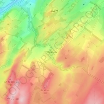
Nom : Carte topographique Kirkton, altitude, relief.
Lieu : Kirkton, Scottish Borders, Scotland, TD9 8QJ, United Kingdom (55.39676 -2.74848 55.43676 -2.70848)
Altitude moyenne : 204 m
Altitude minimum : 91 m
Altitude maximum : 297 m
Autres cartes topographiques
Cliquez sur une carte pour visualiser sa topographie, son altitude et son relief.
Greenknowe Tower
United Kingdom > Scotland > Scottish Borders > Gordon > Nether Huntlywood
Altitude moyenne : 157 m
Moffat Hills
United Kingdom > Scotland > Scottish Borders > Tweedsmuir
The Megget Stane (OS. Ref. NT152203) is by a cattle grid at the highest point between the Talla and Megget reservoirs on the minor road which runs from Tweedsmuir on the A701 to Cappercleuch by shore of St Mary's Loch. It is quite easy to miss the stone when coming from Talla as it is hidden by a gate. At an…
Altitude moyenne : 430 m
Curling Pond
United Kingdom > Scotland > Scottish Borders > Earlston > Georgefield
Altitude moyenne : 153 m
Hirsel Lake
United Kingdom > Scotland > Scottish Borders > Coldstream > The Hirsel
Altitude moyenne : 37 m