Géolocaliser

Carte topographique Scottish Borders

Cliquez sur la carte pour afficher l’altitude.

À propos de cette carte

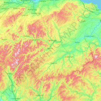
Nom : Carte topographique Scottish Borders, altitude, relief.

Lieu : Scottish Borders, Scotland, United Kingdom (55.10834 -3.53980 55.94662 -2.03321)

Altitude moyenne : 257 m

Altitude minimum : 0 m

Altitude maximum : 836 m

Autres cartes topographiques

Cliquez sur une carte pour visualiser sa topographie, son altitude et son relief.

Edinburgh

United Kingdom > Scotland > Edinburgh

Some have called Edinburgh the Athens of the North for a variety of reasons. The earliest comparison between the two cities showed that they had a similar topography, with the Castle Rock of Edinburgh performing a similar role to the Athenian Acropolis. Both of them had flatter, fertile agricultural land…

Altitude moyenne : 104 m

Glasgow

United Kingdom > Scotland > Glasgow City

Glasgow itself was reputed to have been founded by the Christian missionary Saint Mungo in the 6th century. He established a church on the Molendinar Burn, where the present Glasgow Cathedral stands, and in the following years Glasgow became a religious centre. Glasgow grew over the following centuries. The…

Altitude moyenne : 128 m

Scottish Highlands

United Kingdom > Scotland > Highland

The entire region was covered by ice sheets during the Pleistocene ice ages, save perhaps for a few nunataks. The complex geomorphology includes incised valleys and lochs carved by the action of mountain streams and ice, and a topography of irregularly distributed mountains whose summits have similar heights…

Altitude moyenne : 907 m

Glencoe

United Kingdom > Scotland > Highland

Altitude moyenne : 114 m

Fort William

United Kingdom > Scotland > Highland

Fort William has an oceanic climate (Cfb) with moderate, but generally cool, temperatures and abundant precipitation. In the towns immediate vicinity, there are significant variations in elevation, which leads to some uninhabited areas near the town having a subpolar oceanic climate (Cfc), or, at the absolute…

Altitude moyenne : 122 m

Aberdeen

United Kingdom > Scotland > Aberdeen

Two weather stations collect climate data for the area, Aberdeen/Dyce Airport, and Craibstone. Both are about 4 1⁄2 miles (7 km) to the north west of the city centre, and given that they are in close proximity to each other, exhibit very similar climatic regimes. Dyce tends to have marginally warmer daytime…

Altitude moyenne : 52 m

Oban

United Kingdom > Scotland > Argyll and Bute

Altitude moyenne : 52 m

Bathgate

United Kingdom > Scotland > West Lothian

In the 1846 book A Topographical Dictionary of Scotland, Samuel Lewis writes.

Altitude moyenne : 167 m

Newtonmore

United Kingdom > Scotland > Highland

Newtonmore is located within the Cairngorms National Park, approximately 3 miles (5 km) southwest of Kingussie and 15 miles (24 km) southwest of Aviemore. It is on the northeastern bank of the River Spey, between the River Calder and the Allt Lairaidh, at an altitude of approximately 250 metres (820 ft).

Altitude moyenne : 283 m

Oldmeldrum

United Kingdom > Scotland > Aberdeenshire

Altitude moyenne : 121 m

Inverness

United Kingdom > Scotland > Highland

Altitude moyenne : 163 m

The Campsie Fells

United Kingdom > Scotland

Altitude moyenne : 431 m

Garmond

United Kingdom > Scotland > Aberdeenshire > Cuminestown

Altitude moyenne : 117 m

Banchory

United Kingdom > Scotland > Aberdeenshire

Altitude moyenne : 117 m

Linlithgow

United Kingdom > Scotland > West Lothian

Altitude moyenne : 95 m

Longforgan

United Kingdom > Scotland > Perth and Kinross

Altitude moyenne : 29 m

Ben Nevis

United Kingdom > Scotland > Highland

Ben Nevis has a highland (alpine) maritime (oceanic) polar climate (ET climate in the Köppen classification). Ben Nevis's elevation, maritime location and topography frequently lead to cool and cloudy weather conditions, which can pose a danger to ill-equipped walkers. According to the observations carried…

Altitude moyenne : 912 m

Kennoway

United Kingdom > Scotland > Fife

Altitude moyenne : 80 m

Kingsbarns

United Kingdom > Scotland > Fife

Altitude moyenne : 32 m

Beauly Firth

United Kingdom > Scotland > Highland > Inverness

Altitude moyenne : 4 m

Kilsyth

United Kingdom > Scotland > North Lanarkshire

Historically part of Stirlingshire, Kilsyth is at an elevation of 200 feet (60 metres) above sea level and occupies a narrow strip of land between the Kilsyth Hills to the north and the River Kelvin to the south. To the east and west it is bordered by marshland and bogs. The centre of the town is close to the…

Altitude moyenne : 161 m

Beinn na Lap

United Kingdom > Scotland > Highland

Altitude moyenne : 654 m

Dundee

United Kingdom > Scotland > Dundee City

Dundee sits on the north bank of the Firth of Tay on the eastern, North Sea Coast of Scotland. The city lies 36.1 miles (58 km) NNE of Edinburgh and 360.6 miles (580 km) NNW of London. The built-up area occupies a roughly rectangular shape 8.3 miles (13 km) long by 2.5 miles (4 km) wide, aligned in an east to…

Altitude moyenne : 82 m

Cambuslang

United Kingdom > Scotland > South Lanarkshire

Altitude moyenne : 70 m

Dunbar

United Kingdom > Scotland > East Lothian

Altitude moyenne : 24 m

Argyll and Bute

United Kingdom > Scotland

Altitude moyenne : 683 m

Western Isles

United Kingdom > Scotland

Altitude moyenne : 23 m

Ayrshire

United Kingdom > Scotland

Altitude moyenne : 141 m

Inchmickery

United Kingdom > Scotland

Altitude moyenne : 0 m

Ailsa Craig

United Kingdom > Scotland

In a small glen above Ailsa Castle, a small freshwater body known as the Garry Loch is located at an altitude of 247 m (810 ft), with a depth of at least 17 feet.

Altitude moyenne : 14 m

Iona

United Kingdom > Scotland

Altitude moyenne : 9 m

Banffshire

United Kingdom > Scotland

Altitude moyenne : 191 m

Stirlingshire

United Kingdom > Scotland

Altitude moyenne : 222 m

Mull of Kintyre

United Kingdom > Scotland

Ailsa Craig and the County Antrim coast of Ulster and Rathlin Island are all clearly visible from the Mull. On clearer days it is also possible to make out Malin Head in Inishowen in County Donegal in the west of Ulster, and the Ayrshire coast on the other side of Ailsa Craig. Other islands in the Firth of…

Altitude moyenne : 84 m

Glen Dochart

United Kingdom > Scotland

Altitude moyenne : 469 m

Auchencorth Moss

United Kingdom > Scotland

Altitude moyenne : 281 m

Denton Burn

United Kingdom > Scotland

Altitude moyenne : 154 m

Taynish Island

United Kingdom > Scotland

Altitude moyenne : 11 m

Devil's Beef Tub

United Kingdom > Scotland

Altitude moyenne : 376 m

Grey Mare's Tail

United Kingdom > Scotland

Altitude moyenne : 466 m

Meall Aundrary

United Kingdom > Scotland

Altitude moyenne : 194 m

River Kerry

United Kingdom > Scotland

Altitude moyenne : 118 m

Abhainn a' Ghlinne Ghil

United Kingdom > Scotland

Altitude moyenne : 138 m

Burian Hole

United Kingdom > Scotland

Altitude moyenne : 36 m

Papa

United Kingdom > Scotland

Altitude moyenne : 2 m

Sgùrr na Stri

United Kingdom > Scotland

Altitude moyenne : 92 m

Braid Hill

United Kingdom > Scotland

Altitude moyenne : 353 m

Loch Urigill

United Kingdom > Scotland

Altitude moyenne : 172 m

Buachaille Etive Mor

United Kingdom > Scotland

Altitude moyenne : 585 m

Highland

United Kingdom > Scotland

Altitude moyenne : 402 m

Glen Croe

United Kingdom > Scotland

Altitude moyenne : 355 m

Inverness-shire

United Kingdom > Scotland

Altitude moyenne : 333 m

Barrnacarry Bay

United Kingdom > Scotland

Altitude moyenne : 32 m

Snap

United Kingdom > Scotland

Altitude moyenne : 3 m

Lanarkshire

United Kingdom > Scotland

Altitude moyenne : 183 m

Rubha nam Bùthan

United Kingdom > Scotland

Altitude moyenne : 15 m

The Minch

United Kingdom > Scotland

Altitude moyenne : 63 m

Firth of Clyde

United Kingdom > Scotland

Altitude moyenne : 0 m

St Magnus' Bay

United Kingdom > Scotland

Altitude moyenne : 6 m

Rutherglen

United Kingdom > Scotland > South Lanarkshire

Altitude moyenne : 55 m

Bo'ness

United Kingdom > Scotland > Falkirk

Altitude moyenne : 29 m

Earnslaw

United Kingdom > Scotland > Scottish Borders

Altitude moyenne : 68 m

Coatbridge

United Kingdom > Scotland > North Lanarkshire

The topography of Coatbridge was an important feature in the town's development during the industrial revolution. Coatbridge rests 60 metres below the "Slamannan plateau" and neighbouring Airdrie sits on its edge. The low-lying flat ground of Coatbridge was a vital factor in the siting of the town's blast…

Altitude moyenne : 100 m

Thurso

United Kingdom > Scotland > Highland

Altitude moyenne : 25 m

Elgin

United Kingdom > Scotland > Moray

Elgin is first documented in the Cartulary of Moray in 1190 AD. It was created a royal burgh in the 12th century by King David I of Scotland, and by that time had a castle on top of the present-day Lady Hill to the west of the town. The origin of the name Elgin is likely to be Celtic. It may derive from…

Altitude moyenne : 26 m

Dunoon

United Kingdom > Scotland > Argyll and Bute

Altitude moyenne : 98 m

Clarkston

United Kingdom > Scotland > East Renfrewshire

Altitude moyenne : 94 m

Crieff

United Kingdom > Scotland > Perth and Kinross

Altitude moyenne : 115 m

Kilwinning

United Kingdom > Scotland > North Ayrshire

Altitude moyenne : 36 m

Forsinard

United Kingdom > Scotland > Highland

Altitude moyenne : 171 m

Scourie

United Kingdom > Scotland > Highland

Altitude moyenne : 51 m

Torridon

United Kingdom > Scotland > Highland

Altitude moyenne : 236 m

Kinlochewe

United Kingdom > Scotland > Highland

Altitude moyenne : 153 m

New Gilston

United Kingdom > Scotland > Fife

Altitude moyenne : 168 m

Dornoch

United Kingdom > Scotland > Highland

Altitude moyenne : 19 m

Lochore

United Kingdom > Scotland > Fife

Altitude moyenne : 124 m

Arisaig

United Kingdom > Scotland > Highland

Altitude moyenne : 54 m

Ben Chonzie

United Kingdom > Scotland > Perth and Kinross

Altitude moyenne : 695 m

Roslin

United Kingdom > Scotland > Midlothian

Altitude moyenne : 155 m

Buckhaven

United Kingdom > Scotland > Fife

Altitude moyenne : 21 m

River Devon

United Kingdom > Scotland > Clackmannanshire > Tillicoultry

The source of the river is Blairdenon Hill in the Ochils at an altitude of 1,800 feet (550 m). Upper areas have been dammed, creating Upper Glendevon, Lower Glendevon and Castlehill reservoirs. The Devon then flows east and southeast through Glendevon, turning southwest at Crook of Devon and then continuing…

Altitude moyenne : 96 m

Kilmacolm

United Kingdom > Scotland > Inverclyde

Altitude moyenne : 114 m

Falkirk

United Kingdom > Scotland > Falkirk

Falkirk is located in an area of undulating topography between the Slamannan Plateau and the upper reaches of the Firth of Forth. The area to the north of Falkirk is part of the floodplain of the River Carron. Two tributaries of the River Carron - the East Burn and the West Burn flow through the town and form…

Altitude moyenne : 69 m

Stirling

United Kingdom > Scotland > Stirling

Altitude moyenne : 161 m

Jedburgh

United Kingdom > Scotland > Scottish Borders

Altitude moyenne : 151 m

Brechin

United Kingdom > Scotland > Angus

Altitude moyenne : 71 m

Dunfermline

United Kingdom > Scotland > Fife > Dunfermline

Altitude moyenne : 80 m

Aberlour

United Kingdom > Scotland > Moray

According to the 1846 A Topographical Dictionary of Scotland, "This parish, formerly called Skirdustan, signifying, in the Gaelic tongue, 'the division of Dustan', its tutelary saint, derived its present name from its situation at the mouth of a noisy burn, which discharges itself into the river Spey."

Altitude moyenne : 160 m

Inverurie

United Kingdom > Scotland > Aberdeenshire

Altitude moyenne : 102 m

Huntly

United Kingdom > Scotland > Aberdeenshire

Altitude moyenne : 171 m

Stonehaven

United Kingdom > Scotland > Aberdeenshire

Altitude moyenne : 57 m

Ballater

United Kingdom > Scotland > Aberdeenshire

Ballater (/ˈbælətər/, Scottish Gaelic: Bealadair) is a village in Aberdeenshire, Scotland, on the River Dee, immediately east of the Cairngorm Mountains. Situated at an elevation of 213 metres (699 feet), Ballater is a centre for hikers and known for its spring water, once said to cure scrofula. It is home…

Altitude moyenne : 360 m

Équipez-vous pour votre prochaine aventure :

🔥Réchauds de camping - Réchauds compacts pour cuisine outdoor
🗻Raquettes à neige - Progression sur neige profonde
🛁Serviette microfibre - Séchage rapide et encombrement minimum pour le bivouac
🎒Sac à dos de trekking - Volume idéal pour une sortie à la journée ou avec une nuit en refuge
🥾Chaussures de marche Homme - Maintien et imperméabilité pour les sentiers techniques suisses

En tant que Partenaire Amazon, ce site perçoit une commission sur les achats éligibles sans surcoût pour vous.