Géolocaliser

Carte topographique West Lothian

Cliquez sur la carte pour afficher l’altitude.

À propos de cette carte

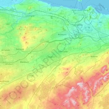
Nom : Carte topographique West Lothian, altitude, relief.

Lieu : West Lothian, Scotland, United Kingdom (55.77071 -3.83126 56.00551 -3.38663)

Altitude moyenne : 184 m

Altitude minimum : 0 m

Altitude maximum : 564 m

Autres cartes topographiques

Cliquez sur une carte pour visualiser sa topographie, son altitude et son relief.

Glasgow

United Kingdom > Scotland > Glasgow City

Glasgow itself was reputed to have been founded by the Christian missionary Saint Mungo in the 6th century. He established a church on the Molendinar Burn, where the present Glasgow Cathedral stands, and in the following years Glasgow became a religious centre. Glasgow grew over the following centuries. The…

Altitude moyenne : 128 m

Edinburgh

United Kingdom > Scotland > Edinburgh

Some have called Edinburgh the Athens of the North for a variety of reasons. The earliest comparison between the two cities showed that they had a similar topography, with the Castle Rock of Edinburgh performing a similar role to the Athenian Acropolis. Both of them had flatter, fertile agricultural land…

Altitude moyenne : 104 m

Dundee

United Kingdom > Scotland > Dundee City

Dundee sits on the north bank of the Firth of Tay on the eastern, North Sea Coast of Scotland. The city lies 36.1 miles (58 km) NNE of Edinburgh and 360.6 miles (580 km) NNW of London. The built-up area occupies a roughly rectangular shape 8.3 miles (13 km) long by 2.5 miles (4 km) wide, aligned in an east to…

Altitude moyenne : 82 m

Ben Nevis

United Kingdom > Scotland > Highland

Ben Nevis has a highland (alpine) maritime (oceanic) polar climate (ET climate in the Köppen classification). Ben Nevis's elevation, maritime location and topography frequently lead to cool and cloudy weather conditions, which can pose a danger to ill-equipped walkers. According to the observations carried…

Altitude moyenne : 912 m

Pitlochry

United Kingdom > Scotland > Perth and Kinross

Altitude moyenne : 276 m

Falkirk

United Kingdom > Scotland > Falkirk

Falkirk is located in an area of undulating topography between the Slamannan Plateau and the upper reaches of the Firth of Forth. The area to the north of Falkirk is part of the floodplain of the River Carron. Two tributaries of the River Carron - the East Burn and the West Burn flow through the town and form…

Altitude moyenne : 69 m

St Andrews

United Kingdom > Scotland > Fife

Altitude moyenne : 38 m

Grantown-on-Spey

United Kingdom > Scotland > Highland

Altitude moyenne : 271 m

Turriff

United Kingdom > Scotland > Aberdeenshire

Altitude moyenne : 91 m

Aberdeen

United Kingdom > Scotland > Aberdeen

Two weather stations collect climate data for the area, Aberdeen/Dyce Airport, and Craibstone. Both are about 4 1⁄2 miles (7 km) to the north west of the city centre, and given that they are in close proximity to each other, exhibit very similar climatic regimes. Dyce tends to have marginally warmer daytime…

Altitude moyenne : 52 m

Cumbernauld

United Kingdom > Scotland > North Lanarkshire > Cumbernauld

Cumbernauld's name probably comes from the Gaelic comar nan allt, meaning "meeting of the burns or streams". There are differing views as to the etymology of this. One theory is that from its high point in the Central Belt, its streams flow both west to the River Clyde and east to the Firth of Forth so…

Altitude moyenne : 111 m

Fallin

United Kingdom > Scotland > Stirling

Altitude moyenne : 12 m

Jedburgh

United Kingdom > Scotland > Scottish Borders

Altitude moyenne : 151 m

Glencoe

United Kingdom > Scotland > Highland

Altitude moyenne : 114 m

Inverness

United Kingdom > Scotland > Highland

Altitude moyenne : 163 m

Brechin

United Kingdom > Scotland > Angus

Altitude moyenne : 71 m

Aviemore

United Kingdom > Scotland > Highland

Altitude moyenne : 331 m

Lanarkshire

United Kingdom > Scotland

Altitude moyenne : 183 m

Rubha nam Bùthan

United Kingdom > Scotland

Altitude moyenne : 15 m

The Minch

United Kingdom > Scotland

Altitude moyenne : 63 m

Firth of Clyde

United Kingdom > Scotland

Altitude moyenne : 0 m

St Magnus' Bay

United Kingdom > Scotland

Altitude moyenne : 6 m

Dunfermline

United Kingdom > Scotland > Fife > Dunfermline

Altitude moyenne : 80 m

Kilmarnock

United Kingdom > Scotland > East Ayrshire

Altitude moyenne : 56 m

Banffshire

United Kingdom > Scotland

Altitude moyenne : 191 m

Stirlingshire

United Kingdom > Scotland

Altitude moyenne : 222 m

Bunessan

United Kingdom > Scotland > Argyll and Bute

Altitude moyenne : 32 m

Shuna

United Kingdom > Scotland > Argyll and Bute > Toberonochy

Altitude moyenne : 9 m

Sgor an Lochain Uaine

United Kingdom > Scotland > Aberdeenshire

Altitude moyenne : 1’008 m

Broad Cairn

United Kingdom > Scotland > Aberdeenshire

It has an elevation of 998 m (3,274 ft) and a prominence of 64 m (210 ft) and is a Munro.

Altitude moyenne : 782 m

Ben Hope

United Kingdom > Scotland > Highland

Altitude moyenne : 490 m

Ben Klibreck

United Kingdom > Scotland > Highland

Ben Klibreck (Scottish Gaelic: Beinn Chlìbric) is a Scottish mountain located in central Sutherland. It is an isolated mountain, rising above a large area of moorland. The highest point, Meall nan Con (the mound of the dogs), rises to 962 metres (3,156 ft) elevation and is therefore the second most northerly…

Altitude moyenne : 551 m

Aberlour

United Kingdom > Scotland > Moray

According to the 1846 A Topographical Dictionary of Scotland, "This parish, formerly called Skirdustan, signifying, in the Gaelic tongue, 'the division of Dustan', its tutelary saint, derived its present name from its situation at the mouth of a noisy burn, which discharges itself into the river Spey."

Altitude moyenne : 160 m

Peebles

United Kingdom > Scotland > Scottish Borders

Altitude moyenne : 275 m

Livingston

United Kingdom > Scotland > West Lothian

Altitude moyenne : 158 m

Hawick

United Kingdom > Scotland > Scottish Borders

Altitude moyenne : 199 m

Fort William

United Kingdom > Scotland > Highland

Fort William has an oceanic climate (Cfb) with moderate, but generally cool, temperatures and abundant precipitation. In the towns immediate vicinity, there are significant variations in elevation, which leads to some uninhabited areas near the town having a subpolar oceanic climate (Cfc), or, at the absolute…

Altitude moyenne : 122 m

Scottish Highlands

United Kingdom > Scotland > Highland

The entire region was covered by ice sheets during the Pleistocene ice ages, save perhaps for a few nunataks. The complex geomorphology includes incised valleys and lochs carved by the action of mountain streams and ice, and a topography of irregularly distributed mountains whose summits have similar heights…

Altitude moyenne : 907 m

Cairngorm Mountains

United Kingdom > Scotland > Aberdeenshire

In terms of height, remoteness and the severe and changeable weather, the Cairngorms are the most arduous area in the United Kingdom. The plateau area has a Tundra climate (Köppen ET), and the shattered terrain is more like the high ground in high-arctic Canada or northern Norway than what is often observed…

Altitude moyenne : 937 m

Western Isles

United Kingdom > Scotland

Altitude moyenne : 23 m

Ayrshire

United Kingdom > Scotland

Altitude moyenne : 141 m

Inchmickery

United Kingdom > Scotland

Altitude moyenne : 0 m

Ailsa Craig

United Kingdom > Scotland

In a small glen above Ailsa Castle, a small freshwater body known as the Garry Loch is located at an altitude of 247 m (810 ft), with a depth of at least 17 feet.

Altitude moyenne : 14 m

Iona

United Kingdom > Scotland

Altitude moyenne : 9 m

Mull of Kintyre

United Kingdom > Scotland

Ailsa Craig and the County Antrim coast of Ulster and Rathlin Island are all clearly visible from the Mull. On clearer days it is also possible to make out Malin Head in Inishowen in County Donegal in the west of Ulster, and the Ayrshire coast on the other side of Ailsa Craig. Other islands in the Firth of…

Altitude moyenne : 84 m

Uphall Station

United Kingdom > Scotland > West Lothian

Altitude moyenne : 121 m

Kintore

United Kingdom > Scotland > Aberdeenshire

Altitude moyenne : 88 m

Kinknockie Hill

United Kingdom > Scotland > Aberdeenshire

Altitude moyenne : 108 m

New Gilston

United Kingdom > Scotland > Fife

Altitude moyenne : 168 m

Pittenweem

United Kingdom > Scotland > Fife

Altitude moyenne : 12 m

Dunecht

United Kingdom > Scotland > Aberdeenshire

Altitude moyenne : 123 m

Earlston

United Kingdom > Scotland > Scottish Borders

Altitude moyenne : 169 m

Lammermuirs

United Kingdom > Scotland > East Lothian

Altitude moyenne : 266 m

Blythe

United Kingdom > Scotland > Scottish Borders

Altitude moyenne : 255 m

Uplawmoor

United Kingdom > Scotland > East Renfrewshire

Altitude moyenne : 181 m

Alyth

United Kingdom > Scotland > Perth and Kinross

To the northeast of the town a hill fort, possibly of Pictish date or earlier, stands atop Barry (or 'barrow') Hill. It is considered to be one of the best preserved examples of an enclosed hilltop settlement in Scotland. The remains consist of massive collapsed stone ramparts that take advantage of the…

Altitude moyenne : 125 m

Bridge of Craigisla

United Kingdom > Scotland > Angus

Altitude moyenne : 212 m

Banff

United Kingdom > Scotland > Aberdeenshire

Altitude moyenne : 37 m

Garlogie

United Kingdom > Scotland > Aberdeenshire

Altitude moyenne : 87 m

Craigowl Hill

United Kingdom > Scotland > Angus

Altitude moyenne : 292 m

Selkirk

United Kingdom > Scotland > Scottish Borders

Altitude moyenne : 226 m

Chapelhall

United Kingdom > Scotland > North Lanarkshire

Altitude moyenne : 149 m

Snap

United Kingdom > Scotland

Altitude moyenne : 3 m

Stirling

United Kingdom > Scotland > Stirling

Altitude moyenne : 161 m

Teandalloch

United Kingdom > Scotland > Highland > Muir of Ord

Altitude moyenne : 76 m

The Quiraing

United Kingdom > Scotland > Highland

Altitude moyenne : 305 m

Old Man of Storr

United Kingdom > Scotland > Highland

Altitude moyenne : 354 m

Dundee Law

United Kingdom > Scotland > Dundee City > Dundee

Altitude moyenne : 79 m

Edzell

United Kingdom > Scotland > Angus

Altitude moyenne : 69 m

Mugdrum

United Kingdom > Scotland > Fife > Newburgh

Altitude moyenne : 51 m

Hardgate

United Kingdom > Scotland > West Dunbartonshire

Altitude moyenne : 90 m

Scone

United Kingdom > Scotland > Perth and Kinross

Altitude moyenne : 81 m

Ose

United Kingdom > Scotland > Highland

Altitude moyenne : 26 m

Scotlandwell

United Kingdom > Scotland > Perth and Kinross

Altitude moyenne : 168 m

Beeswing

United Kingdom > Scotland > Dumfries and Galloway

Altitude moyenne : 111 m

Newarthill

United Kingdom > Scotland > North Lanarkshire

Altitude moyenne : 132 m

Isle of May

United Kingdom > Scotland > Fife

Altitude moyenne : 1 m

Foss

United Kingdom > Scotland > Perth and Kinross

Altitude moyenne : 271 m

Irvine

United Kingdom > Scotland > North Ayrshire

Altitude moyenne : 13 m

Houston

United Kingdom > Scotland > Renfrewshire

Altitude moyenne : 43 m

Brig o' Turk

United Kingdom > Scotland > Stirling

Altitude moyenne : 212 m

Milton of Ogilvie

United Kingdom > Scotland > Angus

Altitude moyenne : 199 m

North Kessock

United Kingdom > Scotland > Highland

Altitude moyenne : 30 m

Kelty

United Kingdom > Scotland > Fife

Altitude moyenne : 154 m

Kinbuck

United Kingdom > Scotland > Stirling

Altitude moyenne : 129 m

Penchrise Pen

United Kingdom > Scotland > Scottish Borders

Altitude moyenne : 304 m

Kintradwell

United Kingdom > Scotland > Highland

Altitude moyenne : 78 m

Wilson's Pike

United Kingdom > Scotland > Scottish Borders

Altitude moyenne : 362 m

Creag Mèagaidh

United Kingdom > Scotland > Highland

There are three species of deer found at Creag Meagaidh NNR: red, roe and sika. Deer management to reduce numbers takes place at Creag Meagaidh in order to facilitate woodland regeneration. Mountain hares are common on the higher parts of the reserve, whilst pine marten and otter can occasionally be found at…

Altitude moyenne : 928 m

Équipez-vous pour votre prochaine aventure :

🎒Sac à dos de trekking - Volume idéal pour une sortie à la journée ou avec une nuit en refuge
🧢Chapeau de soleil UV - Protection essentielle contre la réverbération solaire en haute altitude
🗻Crampons de randonnée - Adhérence sur neige et glace
🧳Sacs de transport outdoor - Organisation du matériel
🧣Tour de cou multifonction - Protège du froid, du vent ou du soleil selon vos besoins

En tant que Partenaire Amazon, ce site perçoit une commission sur les achats éligibles sans surcoût pour vous.