
Carte topographique Scottish Borders
Cliquez sur la carte pour afficher l’altitude.
À propos de cette carte
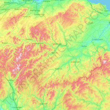
Nom : Carte topographique Scottish Borders, altitude, relief.
Lieu : Scottish Borders, Scotland, United Kingdom (55.10834 -3.53980 55.94662 -2.03321)
Altitude moyenne : 257 m
Altitude minimum : 0 m
Altitude maximum : 836 m
Autres cartes topographiques
Cliquez sur une carte pour visualiser sa topographie, son altitude et son relief.
Edinburgh
United Kingdom > Scotland > Edinburgh
Some have called Edinburgh the Athens of the North for a variety of reasons. The earliest comparison between the two cities showed that they had a similar topography, with the Castle Rock of Edinburgh performing a similar role to the Athenian Acropolis. Both of them had flatter, fertile agricultural land…
Altitude moyenne : 104 m
Glasgow
United Kingdom > Scotland > Glasgow City
Glasgow itself was reputed to have been founded by the Christian missionary Saint Mungo in the 6th century. He established a church on the Molendinar Burn, where the present Glasgow Cathedral stands, and in the following years Glasgow became a religious centre. Glasgow grew over the following centuries. The…
Altitude moyenne : 128 m
Scottish Highlands
United Kingdom > Scotland > Highland
The Scottish Highlands are renowned for their rugged, mountainous terrain that dominates much of the region. Stretching across the northern and central parts of Scotland, the landscape is shaped by ancient geological forces, including the Caledonian Orogeny, which caused significant tectonic collisions…
Altitude moyenne : 907 m
Glasgow
United Kingdom > Scotland > Glasgow City
Glasgow itself was reputed to have been founded by the Christian missionary Saint Mungo in the 6th century. He established a church on the Molendinar Burn, where the present Glasgow Cathedral stands, and in the following years Glasgow became a religious centre. Glasgow grew over the following centuries as part…
Altitude moyenne : 128 m
Aberdeen
United Kingdom > Scotland > Aberdeen
Two weather stations collect climate data for the area, Aberdeen/Dyce Airport, and Craibstone. Both are about 4 1⁄2 miles (7 km) to the north west of the city centre, and given that they are in close proximity to each other, exhibit very similar climatic regimes. Dyce tends to have marginally warmer daytime…
Altitude moyenne : 52 m
Falkirk
United Kingdom > Scotland > Falkirk
Falkirk is located in an area of undulating topography between the Slamannan Plateau and the upper reaches of the Firth of Forth. The area to the north of Falkirk is part of the floodplain of the River Carron. Two tributaries of the River Carron - the East Burn and the West Burn flow through the town and form…
Altitude moyenne : 69 m
Neilston
United Kingdom > Scotland > East Renfrewshire
The topography of the areas around Neilston are varied. To the east, the land is relatively flat, but to the south and west it is steeper, rising to heights of 400–900 ft (122–274 m) above the level of the River Clyde. The highest points in the surrounding areas are Neilston Pad and the Corkendale-law, at…
Altitude moyenne : 149 m
Elgin
United Kingdom > Scotland > Moray
Elgin is first documented in the Cartulary of Moray in 1190 AD. It was created a royal burgh in the 12th century by King David I of Scotland, and by that time had a castle on top of the present-day Lady Hill to the west of the town. The origin of the name Elgin is likely to be Celtic. It may derive from…
Altitude moyenne : 26 m
Cumbernauld
United Kingdom > Scotland > North Lanarkshire > Cumbernauld
Cumbernauld's name probably comes from the Gaelic comar nan allt, meaning "meeting of the burns or streams". There are differing views as to the etymology of this. One theory is that from its high point in the Central Belt, its streams flow both west to the River Clyde and east to the Firth of Forth so…
Altitude moyenne : 111 m
Dundee
United Kingdom > Scotland > Dundee City
Dundee sits on the north bank of the Firth of Tay on the eastern, North Sea Coast of Scotland. The city lies 36.1 miles (58 km) NNE of Edinburgh and 360.6 miles (580 km) NNW of London. The built-up area occupies a roughly rectangular shape 8.3 miles (13 km) long by 2.5 miles (4 km) wide, aligned in an east to…
Altitude moyenne : 82 m
Kirkcaldy
United Kingdom > Scotland > Fife
Towards the end of the 16th century, a detailed assessment on the size of the townscape was carried out. The first estimate of the parish population in 1639 was between 3,000 and 3,200 and around 3,400 by 1691. At the beginning of the 18th century, the population declined. A census by Webster's Topographical…
Altitude moyenne : 50 m
Fort William
United Kingdom > Scotland > Highland
Fort William has an oceanic climate (Cfb) with moderate, but generally cool, temperatures and abundant precipitation. In the towns immediate vicinity, there are significant variations in elevation, which leads to some uninhabited areas near the town having a subpolar oceanic climate (Cfc), or, at the absolute…
Altitude moyenne : 122 m
Ben A'an
United Kingdom > Scotland > Stirling
Ben A'an is a hill in the Trossachs in Scotland. The pointed peak of its west top (454 metres or 1,490 feet in elevation) resembles a small mountain.
Altitude moyenne : 283 m
Ailsa Craig
In a small glen above Ailsa Castle, a small freshwater body known as the Garry Loch is located at an altitude of 247 m (810 ft), with a depth of at least 17 feet.
Altitude moyenne : 14 m
Mull of Kintyre
Ailsa Craig and the County Antrim coast of Ulster and Rathlin Island are all clearly visible from the Mull. On clearer days it is also possible to make out Malin Head in Inishowen in County Donegal in the west of Ulster, and the Ayrshire coast on the other side of Ailsa Craig. Other islands in the Firth of…
Altitude moyenne : 84 m
Fraserburgh
United Kingdom > Scotland > Aberdeenshire
Fraserburgh is also notable for having the highest ever recorded wind speed in the UK at a low altitude. The 142 mph (229 km/h) gust was recorded on 13 February 1989 at Kinnaird Head Lighthouse. The corresponding hourly mean speed was 78 mph (126 km/h).
Altitude moyenne : 9 m
Aberlour
United Kingdom > Scotland > Moray
According to the 1846 A Topographical Dictionary of Scotland, "This parish, formerly called Skirdustan, signifying, in the Gaelic tongue, 'the division of Dustan', its tutelary saint, derived its present name from its situation at the mouth of a noisy burn, which discharges itself into the river Spey."
Altitude moyenne : 160 m
Ballater
United Kingdom > Scotland > Aberdeenshire
Ballater (/ˈbælətər/, Scottish Gaelic: Bealadair) is a village in Aberdeenshire, Scotland, on the River Dee, immediately east of the Cairngorm Mountains. Situated at an elevation of 213 metres (699 feet), Ballater is a centre for hikers and known for its spring water, once said to cure scrofula. It is home…
Altitude moyenne : 360 m
Strathpeffer
United Kingdom > Scotland > Highland
It lies in a strath 5 miles (8 km) west of Dingwall, with the elevation ranging from 60 to 120 m (200 to 400 ft) above sea level. Sheltered on the west and north, it has a comparatively dry and warm climate.
Altitude moyenne : 127 m
Airdrie
United Kingdom > Scotland > North Lanarkshire
Airdrie's name first appeared in the Register of the Great Seal of Scotland (Registrum Magni Sigilii Regum Scotorum) in 1373 as Ardre. By 1546 it had become Ardry and by 1587 it was known as Ardrie. In 1630 it finally appeared in the Register as Airdrie. Given the topography of the area, the most likely…
Altitude moyenne : 135 m
Pentland Hills Regional Park
United Kingdom > Scotland > Edinburgh > Peggyslea
Altitude moyenne : 249 m