
Carte topographique Kilwinning
Cliquez sur la carte pour afficher l’altitude.
À propos de cette carte
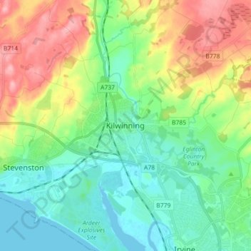
Nom : Carte topographique Kilwinning, altitude, relief.
Lieu : Kilwinning, North Ayrshire, Scotland, KA13 6AD, United Kingdom (55.61400 -4.73920 55.69400 -4.65920)
Altitude moyenne : 36 m
Altitude minimum : 0 m
Altitude maximum : 107 m
Autres cartes topographiques
Cliquez sur une carte pour visualiser sa topographie, son altitude et son relief.
Isle of Arran
United Kingdom > Scotland > North Ayrshire
The island has three endemic species of tree, the Arran whitebeams. These trees are the Scottish or Arran whitebeam (Sorbus arranensis), the bastard mountain ash or cut-leaved whitebeam (Sorbus pseudofennica) and the Catacol whitebeam (Sorbus pseudomeinichii). If rarity is measured by numbers alone they are…
Altitude moyenne : 98 m