
Carte topographique Brittas Bay
Carte interactive
Cliquez sur la carte pour afficher l’altitude.
À propos de cette carte
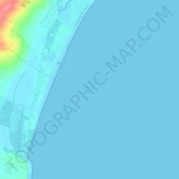
Nom : Carte topographique Brittas Bay, altitude, relief.
Lieu : Brittas Bay, Ireland (52.88004 -6.05027 52.88014 -6.05017)
Altitude moyenne : 4 m
Altitude minimum : 0 m
Altitude maximum : 79 m
Autres cartes topographiques
Cliquez sur une carte pour visualiser sa topographie, son altitude et son relief.
Swords
Swords, Fingal, County Dublin, Leinster, Ireland
Altitude moyenne : 25 m
Ninemilehouse
Ninemilehouse, Garrangibbon, The Municipal District of Carrick-on-Suir, County Tipperary, Munster, Ireland
Altitude moyenne : 149 m
Clonmany
Clonmany, Inishowen Municipal District, County Donegal, F93 RRX6, Ireland
Altitude moyenne : 47 m
Rosroe
Rosroe, Moyrus ED, Conamara Municipal District, County Galway, Connacht, Ireland
Altitude moyenne : 9 m
Thurles
Thurles, The Municipal District of Thurles, County Tipperary, Munster, Ireland
Altitude moyenne : 101 m
Finglas East
Ireland > County Dublin > Dublin
Finglas East, Finglas, Ballygall A ED, Dublin, County Dublin, Leinster, Ireland
Altitude moyenne : 57 m
Curraghmore
Curraghmore, Portlaw, The Municipal District of Comeragh, County Waterford, Munster, Ireland
Altitude moyenne : 95 m
Sandymount
Ireland > County Dublin > Dublin
Sandymount, Pembroke East C ED, Dublin, County Dublin, Leinster, Ireland
Altitude moyenne : 5 m
Listerlin
Listerlin, The Municipal District of Piltown, County Kilkenny, Leinster, Ireland
Altitude moyenne : 140 m
Curraghmore House
Curraghmore House, King John's Bridge, Portlaw, The Municipal District of Comeragh, County Waterford, Munster, Ireland
Altitude moyenne : 88 m
Slane
Slane, The Municipal District of Laytown — Bettystown, County Meath, Leinster, Ireland
Altitude moyenne : 66 m
Athenry
Athenry, Athenry-Oranmore Municipal District, County Galway, Connacht, Ireland
Altitude moyenne : 42 m
Municipal District of Carrigaline
Municipal District of Carrigaline, County Cork, Munster, Ireland
Altitude moyenne : 52 m
Dublin (Finglas)
Ireland > County Dublin > Dublin
Dublin (Finglas), Dublin, Fingal, County Dublin, Leinster, Ireland
Altitude moyenne : 48 m
Rathfeigh
Rathfeigh, Rathfeigh ED, The Municipal District of Ashbourne, County Meath, Leinster, Ireland
Altitude moyenne : 65 m
Rathmore
Rathmore, Rathmore ED, Killarney Municipal District, County Kerry, Munster, P51 PT66, Ireland
Altitude moyenne : 149 m
The Municipal District of Adare — Rathkeale
The Municipal District of Adare — Rathkeale, County Limerick, Munster, Ireland
Altitude moyenne : 74 m
Nenagh
Nenagh, The Municipal District of Nenagh, County Tipperary, Munster, Ireland
Altitude moyenne : 59 m
Ballinasloe
Ballinasloe, County Galway, Connacht, Ireland
Altitude moyenne : 46 m
Clooney
Clooney, Killaloe Municipal District, County Clare, Munster, Ireland
Altitude moyenne : 57 m
Meenane
Meenane, Watergrasshill, Municipal District of Cobh, County Cork, Munster, Ireland
Altitude moyenne : 173 m
Burrow
Burrow, Kilcumeragh ED, The Municipal District of Tullamore, County Offaly, Leinster, Ireland
Altitude moyenne : 64 m
Cruit Island
Cruit Island, Rutland ED, Glenties Municipal District, County Donegal, Ireland
Altitude moyenne : 6 m
Stradbally
Stradbally, Stradbally ED, The Municipal District of Graiguecullen — Portarlington, County Laois, Leinster, Ireland
Altitude moyenne : 92 m
Corballis
Corballis, Donabate DED 1986, Fingal, County Dublin, Leinster, Ireland
Altitude moyenne : 3 m
Carrowmore
Carrowmore, Kilmacowen ED, Sligo Municipal Borough District, County Sligo, Connacht, Ireland
Altitude moyenne : 36 m
Ballyjamesduff Municipal District
Ballyjamesduff Municipal District, County Cavan, Ulster, Ireland
Altitude moyenne : 100 m
Lisfannan
Lisfannan, Burt ED, Inishowen Municipal District, County Donegal, Ireland
Altitude moyenne : 48 m
Murvagh Lower
Murvagh Lower, Ballintra ED, Donegal Municipal District, County Donegal, Ireland
Altitude moyenne : 2 m
Rosses Upper
Rosses Upper, Drumcliff West ED, Sligo Municipal Borough District, County Sligo, Connacht, Ireland
Altitude moyenne : 8 m
Curraghboy
Curraghboy, Castleffrench ED, Ballinasloe Municipal District, County Galway, Connacht, Ireland
Altitude moyenne : 53 m
Murreagh
Murreagh, Kenmare Municipal District, County Kerry, Munster, V92 P681, Ireland
Altitude moyenne : 37 m
Lahinch
Lahinch, Ennistimon ED, West Clare Municipal District, County Clare, Munster, Ireland
Altitude moyenne : 35 m
Dough
Dough, Crookhaven ED, West Cork, County Cork, Munster, Ireland
Altitude moyenne : 35 m
Bartragh
Bartragh, Castleconor West Electoral Division, Ballymote-Tubbercurry Municipal District, County Sligo, Connacht, Ireland
Altitude moyenne : 6 m
Dooaghs
Dooaghs, Caragh ED, Kenmare Municipal District, County Kerry, Munster, Ireland
Altitude moyenne : 10 m
Ballyconneely
Ballyconneely, Conamara Municipal District, County Galway, Connacht, Ireland
Altitude moyenne : 8 m
Castlegregory
Castlegregory, Kenmare Municipal District, County Kerry, Munster, V92 F6NX, Ireland
Altitude moyenne : 17 m
Ballyliffin
Ballyliffin, Inishowen Municipal District, County Donegal, Ulster, Ireland
Altitude moyenne : 76 m
Mount Lucas
Mount Lucas, Esker ED, The Municipal District of Edenderry, County Offaly, Leinster, R35 XW10, Ireland
Altitude moyenne : 76 m
Grand Canal - Barrow Line
Ireland > County Kildare > Athy
Grand Canal - Barrow Line, Athy, Athy Urban West ED, The Municipal District of Athy, County Kildare, Leinster, R14 EH50, Ireland
Altitude moyenne : 60 m
Bearlough
Bearlough, Toomour ED, Ballymote-Tubbercurry Municipal District, County Sligo, Connacht, Ireland
Altitude moyenne : 72 m
Dunfanaghy
Dunfanaghy, County Donegal, F92 H0CY, Ireland
Altitude moyenne : 23 m
Croaghross
Ireland > County Donegal > Letterkenny
Croaghross, Greenfort ED, Letterkenny, County Donegal, Ireland
Altitude moyenne : 25 m