
Carte topographique Rathfeigh
Carte interactive
Cliquez sur la carte pour afficher l’altitude.
À propos de cette carte
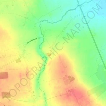
Nom : Carte topographique Rathfeigh, altitude, relief.
Altitude moyenne : 65 m
Altitude minimum : 34 m
Altitude maximum : 92 m
Autres cartes topographiques
Cliquez sur une carte pour visualiser sa topographie, son altitude et son relief.
Slane
Slane, The Municipal District of Laytown — Bettystown, County Meath, Leinster, Ireland
Altitude moyenne : 66 m
Castletown
Castletown, The Municipal District of Kells, County Meath, Leinster, Ireland
Altitude moyenne : 72 m
Navan
Navan, The Municipal District of Navan, County Meath, Leinster, Ireland
Altitude moyenne : 52 m
Longwood
Longwood, Castlerickard ED, The Municipal District of Trim, County Meath, Leinster, Ireland
Altitude moyenne : 69 m
Proudstown
Proudstown, Navan Rural ED, The Municipal District of Navan, County Meath, Leinster, C15 A623, Ireland
Altitude moyenne : 66 m
Dunboyne
Dunboyne, Dunboyne ED, The Municipal District of Ratoath, County Meath, Leinster, Ireland
Altitude moyenne : 72 m
Ballymahon
Ballymahon, Castlerickard ED, The Municipal District of Trim, County Meath, Leinster, Ireland
Altitude moyenne : 66 m
Hill of Tara
Hill of Tara, The Municipal District of Ashbourne, County Meath, Leinster, C15 NYY6, Ireland
Altitude moyenne : 106 m
The Municipal District of Navan
The Municipal District of Navan, County Meath, Leinster, Ireland
Altitude moyenne : 62 m
The Municipal District of Laytown — Bettystown
The Municipal District of Laytown — Bettystown, County Meath, Leinster, Ireland
Altitude moyenne : 72 m
Stonestown
Stonestown, Kilbride ED, The Municipal District of Trim, County Meath, Leinster, Ireland
Altitude moyenne : 69 m
Slane
Slane, Slane ED, The Municipal District of Laytown — Bettystown, County Meath, Leinster, Ireland
Altitude moyenne : 69 m
Clonymeath
Clonymeath, Summerhill ED, The Municipal District of Trim, County Meath, Leinster, Ireland
Altitude moyenne : 85 m
The Municipal District of Kells
The Municipal District of Kells, County Meath, Leinster, Ireland
Altitude moyenne : 96 m
Lobinstown
Lobinstown, Killary ED, The Municipal District of Laytown — Bettystown, County Meath, Leinster, Ireland
Altitude moyenne : 70 m
Gaskinstown
Gaskinstown, Duleek ED, The Municipal District of Laytown — Bettystown, County Meath, Leinster, Ireland
Altitude moyenne : 44 m
Dunshaughlin
Ireland > County Meath > Dunshaughlin
Dunshaughlin, The Municipal District of Ratoath, County Meath, Leinster, A85 C840, Ireland
Altitude moyenne : 99 m
Dunboyne
Ireland > County Meath > Dunboyne
Dunboyne, The Municipal District of Ratoath, County Meath, Leinster, A86 R688, Ireland
Altitude moyenne : 73 m
Kells
Ireland > County Meath > Kells
Kells, The Municipal District of Kells, County Meath, Leinster, A82 KD62, Ireland
Altitude moyenne : 70 m
Bettystown
Bettystown, The Municipal District of Laytown — Bettystown, County Meath, Leinster, A92 AH27, Ireland
Altitude moyenne : 6 m
The Municipal District of Ashbourne
The Municipal District of Ashbourne, County Meath, Leinster, Ireland
Altitude moyenne : 75 m
The Municipal District of Ratoath
The Municipal District of Ratoath, County Meath, Leinster, Ireland
Altitude moyenne : 87 m
Navan
Ireland > County Meath > Navan
Navan, The Municipal District of Navan, County Meath, Leinster, C15H6EK, Ireland
Altitude moyenne : 59 m
Ashbourne
Ireland > County Meath > Ashbourne
Ashbourne, The Municipal District of Ashbourne, County Meath, Leinster, A84 WK40, Ireland
Altitude moyenne : 78 m