
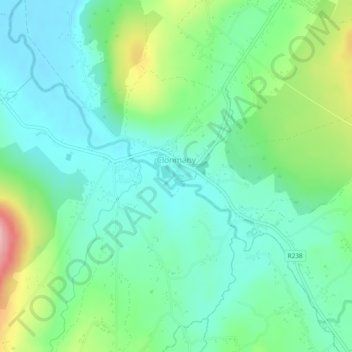
Carte topographique Clonmany
Carte interactive
Cliquez sur la carte pour afficher l’altitude.
À propos de cette carte
Nom : Carte topographique Clonmany, altitude, relief.
Altitude moyenne : 47 m
Altitude minimum : 0 m
Altitude maximum : 168 m
The village claims to be the youngest in Inishowen. The 18th century travel writer - Richard Pococke - did not mention the village when he toured the area in 1752. The village is mentioned in Topographia Hibernica, published in 1795. It did not feature in the census of 1841 or 1851. In the 1861 census, 112 inhabitants are recorded as living in Clonmany in 21 houses. A further 3 houses are recorded as uninhabited.
Autres cartes topographiques
Cliquez sur une carte pour visualiser sa topographie, son altitude et son relief.
Cruit Island
Cruit Island, Rutland ED, Glenties Municipal District, County Donegal, Ireland
Altitude moyenne : 6 m
Lisfannan
Lisfannan, Burt ED, Inishowen Municipal District, County Donegal, Ireland
Altitude moyenne : 48 m
Murvagh Lower
Murvagh Lower, Ballintra ED, Donegal Municipal District, County Donegal, Ireland
Altitude moyenne : 2 m
Ballyliffin
Ballyliffin, Inishowen Municipal District, County Donegal, Ulster, Ireland
Altitude moyenne : 76 m
Dunfanaghy
Dunfanaghy, County Donegal, F92 H0CY, Ireland
Altitude moyenne : 23 m
Croaghross
Ireland > County Donegal > Letterkenny
Croaghross, Greenfort ED, Letterkenny, County Donegal, Ireland
Altitude moyenne : 25 m
Crocknafeola
Crocknafeola, Killybegs ED, Donegal Municipal District, County Donegal, Ireland
Altitude moyenne : 111 m
Carndonagh
Carndonagh, Inishowen Municipal District, County Donegal, Ireland
Altitude moyenne : 54 m
Glenveagh National Park
Glenveagh National Park, Drumnalifferny Mountain, Dunlewy ED, Glenties Municipal District, County Donegal, Ulster, Ireland
Altitude moyenne : 200 m
Greencastle
Greencastle, Inishowen Municipal District, County Donegal, Ireland
Altitude moyenne : 46 m
Rosapenna
Ireland > County Donegal > Letterkenny
Rosapenna, Rosguill ED, Letterkenny, County Donegal, Ireland
Altitude moyenne : 11 m
Corkey
Ireland > County Donegal > Letterkenny
Corkey, Kincraigy ED, Letterkenny, County Donegal, Ireland
Altitude moyenne : 36 m
Donegal
Ireland > County Donegal > Donegal
Donegal, Donegal Municipal District, County Donegal, F94 P028, Ireland
Altitude moyenne : 48 m
Ards Big
Ireland > County Donegal > Letterkenny
Ards Big, Rathmelton ED, Letterkenny, County Donegal, Ulster, Ireland
Altitude moyenne : 62 m
Glenties
Glenties, Glenties ED, Glenties Municipal District, County Donegal, Ulster, F94 KX93, Ireland
Altitude moyenne : 67 m
Alt Upper
Alt Upper, Urney West ED, Lifford-Stranorlar Municipal District, County Donegal, Ulster, Ireland
Altitude moyenne : 142 m
Egglybane
Egglybane, Cloghard ED, Lifford-Stranorlar Municipal District, County Donegal, Ulster, Ireland
Altitude moyenne : 141 m
Carrowkeel
Carrowkeel, County Donegal, Ulster, F92 PP6R, Ireland
Altitude moyenne : 50 m
Drumcarbit
Drumcarbit, Malin ED, Inishowen Municipal District, County Donegal, Ulster, Ireland
Altitude moyenne : 71 m
Cashel
Cashel, Donegal Municipal District, County Donegal, Ireland
Altitude moyenne : 108 m
Maum
Maum, Glenties Municipal District, County Donegal, Ulster, Ireland
Altitude moyenne : 179 m
Raphoe
Raphoe, Lifford-Stranorlar Municipal District, County Donegal, Ulster, Ireland
Altitude moyenne : 87 m
Glengesh
Glengesh, Glengesh ED, Glenties Municipal District, County Donegal, Ireland
Altitude moyenne : 217 m
Malin Head
Malin Head, Ardmalin ED, Inishowen Municipal District, County Donegal, Ireland
Altitude moyenne : 4 m
Gortlee
Ireland > County Donegal > Letterkenny
Gortlee, Letterkenny Rural ED, Letterkenny, County Donegal, Ulster, Ireland
Altitude moyenne : 34 m
Burt
Burt, Inishowen Municipal District, County Donegal, Ulster, Ireland
Altitude moyenne : 87 m
Sheskinarone
Sheskinarone, Dunglow ED, Glenties Municipal District, County Donegal, Ireland
Altitude moyenne : 43 m
Dunfanaghy
Dunfanaghy, Dunfanaghy Electoral Division, Glenties Municipal District, County Donegal, Ulster, F92 H0CY, Ireland
Altitude moyenne : 21 m
Donegal Municipal District
Donegal Municipal District, County Donegal, Ulster, Ireland
Altitude moyenne : 120 m
Inishowen Municipal District
Inishowen Municipal District, County Donegal, Ireland
Altitude moyenne : 59 m
Carndonagh
Ireland > County Donegal > Carndonagh
Carndonagh, Inishowen Municipal District, County Donegal, F93 XD74, Ireland
Altitude moyenne : 78 m
Oort
Oort, Gleneely ED, Inishowen Municipal District, County Donegal, Ireland
Altitude moyenne : 86 m
Kilmacrennan
Ireland > County Donegal > Kilmacrennan
Kilmacrennan, County Donegal, Ireland
Altitude moyenne : 63 m
Mamore Gap
Mamore Gap, Urris Hills Trail, Dunaff ED, Inishowen Municipal District, County Donegal, Ireland
Altitude moyenne : 192 m
Letterkenny
Letterkenny, County Donegal, Ulster, Ireland
Altitude moyenne : 92 m
Stroove
Ireland > County Donegal > Stroove
Stroove, Greencastle ED, Inishowen Municipal District, County Donegal, Ireland
Altitude moyenne : 56 m
Diamond
Diamond, Knock ED, Lifford-Stranorlar Municipal District, County Donegal, F93 Y27K, Ireland
Altitude moyenne : 142 m
Annagry
Ireland > County Donegal > Annagry
Annagry, Glenties Municipal District, County Donegal, Ireland
Altitude moyenne : 32 m
Moyle
Ireland > County Donegal > Letterkenny
Moyle, Ballyarr ED, Letterkenny, County Donegal, Ireland
Altitude moyenne : 55 m
Slieve League
Slieve League, Donegal Municipal District, County Donegal, Ireland
Altitude moyenne : 233 m
Errigal
Errigal, Glenties Municipal District, County Donegal, Ireland
Altitude moyenne : 295 m
Gweedore
Gweedore, Glenties Municipal District, County Donegal, Ireland
Altitude moyenne : 131 m
Dunfanaghy
Ireland > County Donegal > Dunfanaghy
Dunfanaghy, Glenties Municipal District, County Donegal, F92 H0CY, Ireland
Altitude moyenne : 45 m
Aghadowey
Aghadowey, Ballintra ED, Donegal Municipal District, County Donegal, Ireland
Altitude moyenne : 101 m
Lough Eske
Lough Eske, Lough Eask ED, Donegal Municipal District, County Donegal, Ireland
Altitude moyenne : 68 m