
Carte topographique Glenveagh National Park
Carte interactive
Cliquez sur la carte pour afficher l’altitude.
À propos de cette carte
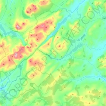
Nom : Carte topographique Glenveagh National Park, altitude, relief.
Altitude moyenne : 200 m
Altitude minimum : 19 m
Altitude maximum : 731 m
Autres cartes topographiques
Cliquez sur une carte pour visualiser sa topographie, son altitude et son relief.
Dunfanaghy
Dunfanaghy, County Donegal, F92 H0CY, Ireland
Altitude moyenne : 23 m
Murvagh Lower
Murvagh Lower, Ballintra ED, Donegal Municipal District, County Donegal, Ireland
Altitude moyenne : 2 m
Cruit Island
Cruit Island, Rutland ED, Glenties Municipal District, County Donegal, Ireland
Altitude moyenne : 6 m
Ballyliffin
Ballyliffin, Inishowen Municipal District, County Donegal, Ulster, Ireland
Altitude moyenne : 76 m
Croaghross
Ireland > County Donegal > Letterkenny
Croaghross, Greenfort ED, Letterkenny, County Donegal, Ireland
Altitude moyenne : 25 m
Lisfannan
Lisfannan, Burt ED, Inishowen Municipal District, County Donegal, Ireland
Altitude moyenne : 48 m
Crocknafeola
Crocknafeola, Killybegs ED, Donegal Municipal District, County Donegal, Ireland
Altitude moyenne : 111 m
Carndonagh
Carndonagh, Inishowen Municipal District, County Donegal, Ireland
Altitude moyenne : 54 m
Greencastle
Greencastle, Inishowen Municipal District, County Donegal, Ireland
Altitude moyenne : 46 m
Rosapenna
Ireland > County Donegal > Letterkenny
Rosapenna, Rosguill ED, Letterkenny, County Donegal, Ireland
Altitude moyenne : 11 m
Corkey
Ireland > County Donegal > Letterkenny
Corkey, Kincraigy ED, Letterkenny, County Donegal, Ireland
Altitude moyenne : 36 m
Donegal
Ireland > County Donegal > Donegal
Donegal, Donegal Municipal District, County Donegal, F94 P028, Ireland
Altitude moyenne : 48 m
Ards Big
Ireland > County Donegal > Letterkenny
Ards Big, Rathmelton ED, Letterkenny, County Donegal, Ulster, Ireland
Altitude moyenne : 62 m
Glenties
Glenties, Glenties ED, Glenties Municipal District, County Donegal, Ulster, F94 KX93, Ireland
Altitude moyenne : 67 m
Alt Upper
Alt Upper, Urney West ED, Lifford-Stranorlar Municipal District, County Donegal, Ulster, Ireland
Altitude moyenne : 142 m
Egglybane
Egglybane, Cloghard ED, Lifford-Stranorlar Municipal District, County Donegal, Ulster, Ireland
Altitude moyenne : 141 m
Carrowkeel
Carrowkeel, County Donegal, Ulster, F92 PP6R, Ireland
Altitude moyenne : 50 m
Drumcarbit
Drumcarbit, Malin ED, Inishowen Municipal District, County Donegal, Ulster, Ireland
Altitude moyenne : 71 m
Cashel
Cashel, Donegal Municipal District, County Donegal, Ireland
Altitude moyenne : 108 m
Maum
Maum, Glenties Municipal District, County Donegal, Ulster, Ireland
Altitude moyenne : 179 m
Raphoe
Raphoe, Lifford-Stranorlar Municipal District, County Donegal, Ulster, Ireland
Altitude moyenne : 87 m
Glengesh
Glengesh, Glengesh ED, Glenties Municipal District, County Donegal, Ireland
Altitude moyenne : 217 m
Malin Head
Malin Head, Ardmalin ED, Inishowen Municipal District, County Donegal, Ireland
Altitude moyenne : 4 m
Gortlee
Ireland > County Donegal > Letterkenny
Gortlee, Letterkenny Rural ED, Letterkenny, County Donegal, Ulster, Ireland
Altitude moyenne : 34 m
Burt
Burt, Inishowen Municipal District, County Donegal, Ulster, Ireland
Altitude moyenne : 87 m
Sheskinarone
Sheskinarone, Dunglow ED, Glenties Municipal District, County Donegal, Ireland
Altitude moyenne : 43 m
Dunfanaghy
Dunfanaghy, Dunfanaghy Electoral Division, Glenties Municipal District, County Donegal, Ulster, F92 H0CY, Ireland
Altitude moyenne : 21 m
Donegal Municipal District
Donegal Municipal District, County Donegal, Ulster, Ireland
Altitude moyenne : 120 m
Inishowen Municipal District
Inishowen Municipal District, County Donegal, Ireland
Altitude moyenne : 59 m
Carndonagh
Ireland > County Donegal > Carndonagh
Carndonagh, Inishowen Municipal District, County Donegal, F93 XD74, Ireland
Altitude moyenne : 78 m
Oort
Oort, Gleneely ED, Inishowen Municipal District, County Donegal, Ireland
Altitude moyenne : 86 m
Kilmacrennan
Ireland > County Donegal > Kilmacrennan
Kilmacrennan, County Donegal, Ireland
Altitude moyenne : 63 m
Mamore Gap
Mamore Gap, Urris Hills Trail, Dunaff ED, Inishowen Municipal District, County Donegal, Ireland
Altitude moyenne : 192 m
Letterkenny
Letterkenny, County Donegal, Ulster, Ireland
Altitude moyenne : 92 m
Stroove
Ireland > County Donegal > Stroove
Stroove, Greencastle ED, Inishowen Municipal District, County Donegal, Ireland
Altitude moyenne : 56 m
Diamond
Diamond, Knock ED, Lifford-Stranorlar Municipal District, County Donegal, F93 Y27K, Ireland
Altitude moyenne : 142 m
Annagry
Ireland > County Donegal > Annagry
Annagry, Glenties Municipal District, County Donegal, Ireland
Altitude moyenne : 32 m
Moyle
Ireland > County Donegal > Letterkenny
Moyle, Ballyarr ED, Letterkenny, County Donegal, Ireland
Altitude moyenne : 55 m
Slieve League
Slieve League, Donegal Municipal District, County Donegal, Ireland
Altitude moyenne : 233 m
Errigal
Errigal, Glenties Municipal District, County Donegal, Ireland
Altitude moyenne : 295 m
Gweedore
Gweedore, Glenties Municipal District, County Donegal, Ireland
Altitude moyenne : 131 m
Dunfanaghy
Ireland > County Donegal > Dunfanaghy
Dunfanaghy, Glenties Municipal District, County Donegal, F92 H0CY, Ireland
Altitude moyenne : 45 m
Aghadowey
Aghadowey, Ballintra ED, Donegal Municipal District, County Donegal, Ireland
Altitude moyenne : 101 m
Lough Eske
Lough Eske, Lough Eask ED, Donegal Municipal District, County Donegal, Ireland
Altitude moyenne : 68 m
Ballybofey
Ballybofey, Lifford-Stranorlar Municipal District, County Donegal, F93 Y27K, Ireland
Altitude moyenne : 98 m