
Carte topographique The Municipal District of Adare — Rathkeale
Carte interactive
Cliquez sur la carte pour afficher l’altitude.
À propos de cette carte
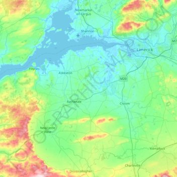
Nom : Carte topographique The Municipal District of Adare — Rathkeale, altitude, relief.
Altitude moyenne : 74 m
Altitude minimum : -7 m
Altitude maximum : 404 m
Autres cartes topographiques
Cliquez sur une carte pour visualiser sa topographie, son altitude et son relief.
Adare
Ireland > County Limerick > The Municipal District of Adare — Rathkeale
Adare, The Municipal District of Adare — Rathkeale, County Limerick, Munster, Ireland
Altitude moyenne : 12 m
Courtbrack
Ireland > County Limerick > Limerick
Courtbrack, Dock D, The Metropolitan District of Limerick City, Limerick, County Limerick, Munster, V94 VH4X, Ireland
Altitude moyenne : 7 m
Galbally
Galbally, County Limerick, Munster, Ireland
Altitude moyenne : 146 m
Strand
Ireland > County Limerick > The Municipal District of Newcastle West
Strand, Monagay, The Municipal District of Newcastle West, County Limerick, Munster, V42 AV66, Ireland
Altitude moyenne : 170 m
Elton
Ireland > County Limerick > The Municipal District of Cappamore — Kilmallock
Elton, The Municipal District of Cappamore — Kilmallock, County Limerick, Munster, Ireland
Altitude moyenne : 104 m
Ardroe
Ireland > County Limerick > The Municipal District of Cappamore — Kilmallock
Ardroe, Kilmurry, The Municipal District of Cappamore — Kilmallock, County Limerick, Munster, Ireland
Altitude moyenne : 102 m
Balline
Ireland > County Limerick > The Municipal District of Cappamore — Kilmallock
Balline, Emlygrennan, The Municipal District of Cappamore — Kilmallock, County Limerick, Munster, Ireland
Altitude moyenne : 109 m
Gooseberry Hill
Ireland > County Limerick > The Municipal District of Cappamore — Kilmallock
Gooseberry Hill, The Municipal District of Cappamore — Kilmallock, County Limerick, Munster, Ireland
Altitude moyenne : 217 m
Lough Gur
Ireland > County Limerick > The Municipal District of Cappamore — Kilmallock
Lough Gur, Grange, The Municipal District of Cappamore — Kilmallock, County Limerick, Munster, Ireland
Altitude moyenne : 84 m
Kilduff
Ireland > County Limerick > The Municipal District of Cappamore — Kilmallock
Kilduff, Grean, The Municipal District of Cappamore — Kilmallock, County Limerick, Munster, Ireland
Altitude moyenne : 80 m
Ballynoe
Ireland > County Limerick > Limerick
Ballynoe, Ballycummin ED, The Metropolitan District of Limerick City, Limerick, County Limerick, Munster, Ireland
Altitude moyenne : 13 m
Limerick
Ireland > County Limerick > Limerick
Limerick, The Metropolitan District of Limerick City, County Limerick, Munster, Ireland
Altitude moyenne : 10 m
Dereen
Ireland > County Limerick > The Metropolitan District of Limerick City
Dereen, Castleconnell, The Metropolitan District of Limerick City, County Limerick, Munster, Ireland
Altitude moyenne : 32 m
Abbeyfeale
Ireland > County Limerick > The Municipal District of Newcastle West > Abbeyfeale
Abbeyfeale, The Municipal District of Newcastle West, County Limerick, Munster, Ireland
Altitude moyenne : 122 m
Milltown Bridge
Ireland > County Limerick > The Municipal District of Adare — Rathkeale
Milltown Bridge, Dromard, The Municipal District of Adare — Rathkeale, County Limerick, Munster, V94 HF80, Ireland
Altitude moyenne : 29 m
Ballylanders
Ireland > County Limerick > The Municipal District of Cappamore — Kilmallock > Ballylanders
Ballylanders, The Municipal District of Cappamore — Kilmallock, County Limerick, Munster, Ireland
Altitude moyenne : 163 m
Kildimo
Ireland > County Limerick > The Municipal District of Adare — Rathkeale
Kildimo, The Municipal District of Adare — Rathkeale, County Limerick, Munster, Ireland
Altitude moyenne : 10 m
Bilboa
Ireland > County Limerick > The Municipal District of Cappamore — Kilmallock
Bilboa, Bilboa ED, The Municipal District of Cappamore — Kilmallock, County Limerick, Munster, Ireland
Altitude moyenne : 88 m
Rathmore
Ireland > County Limerick > The Municipal District of Adare — Rathkeale
Rathmore, The Municipal District of Adare — Rathkeale, County Limerick, Munster, Ireland
Altitude moyenne : 56 m
Limerick City
Limerick City, County Limerick, Munster, Ireland
Altitude moyenne : 102 m
Marlbrook
Ireland > County Limerick > The Municipal District of Adare — Rathkeale
Marlbrook, Kilpeacon, The Municipal District of Adare — Rathkeale, County Limerick, Munster, Ireland
Altitude moyenne : 35 m