
Carte topographique County Limerick
Carte interactive
Cliquez sur la carte pour afficher l’altitude.
À propos de cette carte
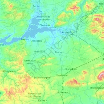
Nom : Carte topographique County Limerick, altitude, relief.
Lieu : County Limerick, Munster, Ireland (52.28020 -9.36543 52.75738 -8.15639)
Altitude moyenne : 110 m
Altitude minimum : -1 m
Altitude maximum : 811 m
One possible meaning for the county's name in Irish Luimneach is "the flat area"; this description is accurate as the land consists mostly of a fertile limestone plain. Moreover, the county is ringed by mountains: the Slieve Felims to the northeast, the Galtees to the southeast, the Ballyhoura Mountains to the south, and the Mullaghareirk Mountains to the southwest and west. The highest point in the county is located in its southeast corner at Galtymore (919 m), which separates Limerick from County Tipperary. Limerick shares the 3rd-highest county peak in Ireland with Tipperary. The county is not simply a plain, its topography consists of hills and ridges. The eastern part of the county is part of the Golden Vale, which is well known for dairy produce and consists of rolling low hills. This gives way to very flat land around the centre of the county, with the exception being Knockfierna at 288 m high. Towards the west, the Mullaghareirk Mountains (Mullach an Radhairc in Irish, roughly meaning "mountains of the view") push across the county offering extensive views east over the county and west into County Kerry.
Autres cartes topographiques
Cliquez sur une carte pour visualiser sa topographie, son altitude et son relief.
The Municipal District of Adare — Rathkeale
The Municipal District of Adare — Rathkeale, County Limerick, Munster, Ireland
Altitude moyenne : 74 m
Adare
Ireland > County Limerick > The Municipal District of Adare — Rathkeale
Adare, The Municipal District of Adare — Rathkeale, County Limerick, Munster, Ireland
Altitude moyenne : 12 m
Courtbrack
Ireland > County Limerick > Limerick
Courtbrack, Dock D, The Metropolitan District of Limerick City, Limerick, County Limerick, Munster, V94 VH4X, Ireland
Altitude moyenne : 7 m
Galbally
Galbally, County Limerick, Munster, Ireland
Altitude moyenne : 146 m
Strand
Ireland > County Limerick > The Municipal District of Newcastle West
Strand, Monagay, The Municipal District of Newcastle West, County Limerick, Munster, V42 AV66, Ireland
Altitude moyenne : 170 m
Elton
Ireland > County Limerick > The Municipal District of Cappamore — Kilmallock
Elton, The Municipal District of Cappamore — Kilmallock, County Limerick, Munster, Ireland
Altitude moyenne : 104 m
Ardroe
Ireland > County Limerick > The Municipal District of Cappamore — Kilmallock
Ardroe, Kilmurry, The Municipal District of Cappamore — Kilmallock, County Limerick, Munster, Ireland
Altitude moyenne : 102 m
Balline
Ireland > County Limerick > The Municipal District of Cappamore — Kilmallock
Balline, Emlygrennan, The Municipal District of Cappamore — Kilmallock, County Limerick, Munster, Ireland
Altitude moyenne : 109 m
Gooseberry Hill
Ireland > County Limerick > The Municipal District of Cappamore — Kilmallock
Gooseberry Hill, The Municipal District of Cappamore — Kilmallock, County Limerick, Munster, Ireland
Altitude moyenne : 217 m
Lough Gur
Ireland > County Limerick > The Municipal District of Cappamore — Kilmallock
Lough Gur, Grange, The Municipal District of Cappamore — Kilmallock, County Limerick, Munster, Ireland
Altitude moyenne : 84 m
Kilduff
Ireland > County Limerick > The Municipal District of Cappamore — Kilmallock
Kilduff, Grean, The Municipal District of Cappamore — Kilmallock, County Limerick, Munster, Ireland
Altitude moyenne : 80 m
Ballynoe
Ireland > County Limerick > Limerick
Ballynoe, Ballycummin ED, The Metropolitan District of Limerick City, Limerick, County Limerick, Munster, Ireland
Altitude moyenne : 13 m
Limerick
Ireland > County Limerick > Limerick
Limerick, The Metropolitan District of Limerick City, County Limerick, Munster, Ireland
Altitude moyenne : 10 m
Dereen
Ireland > County Limerick > The Metropolitan District of Limerick City
Dereen, Castleconnell, The Metropolitan District of Limerick City, County Limerick, Munster, Ireland
Altitude moyenne : 32 m
Abbeyfeale
Ireland > County Limerick > The Municipal District of Newcastle West > Abbeyfeale
Abbeyfeale, The Municipal District of Newcastle West, County Limerick, Munster, Ireland
Altitude moyenne : 122 m
Milltown Bridge
Ireland > County Limerick > The Municipal District of Adare — Rathkeale
Milltown Bridge, Dromard, The Municipal District of Adare — Rathkeale, County Limerick, Munster, V94 HF80, Ireland
Altitude moyenne : 29 m
Ballylanders
Ireland > County Limerick > The Municipal District of Cappamore — Kilmallock > Ballylanders
Ballylanders, The Municipal District of Cappamore — Kilmallock, County Limerick, Munster, Ireland
Altitude moyenne : 163 m
Kildimo
Ireland > County Limerick > The Municipal District of Adare — Rathkeale
Kildimo, The Municipal District of Adare — Rathkeale, County Limerick, Munster, Ireland
Altitude moyenne : 10 m
Bilboa
Ireland > County Limerick > The Municipal District of Cappamore — Kilmallock
Bilboa, Bilboa ED, The Municipal District of Cappamore — Kilmallock, County Limerick, Munster, Ireland
Altitude moyenne : 88 m
Rathmore
Ireland > County Limerick > The Municipal District of Adare — Rathkeale
Rathmore, The Municipal District of Adare — Rathkeale, County Limerick, Munster, Ireland
Altitude moyenne : 56 m
Limerick City
Limerick City, County Limerick, Munster, Ireland
Altitude moyenne : 102 m
Marlbrook
Ireland > County Limerick > The Municipal District of Adare — Rathkeale
Marlbrook, Kilpeacon, The Municipal District of Adare — Rathkeale, County Limerick, Munster, Ireland
Altitude moyenne : 35 m