
Carte topographique Limerick
Carte interactive
Cliquez sur la carte pour afficher l’altitude.
À propos de cette carte
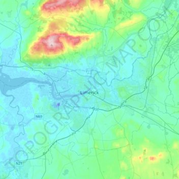
Nom : Carte topographique Limerick, altitude, relief.
Lieu : Limerick, County Limerick, Munster, Ireland (52.57210 -8.80708 52.75738 -8.44254)
Altitude moyenne : 45 m
Altitude minimum : -26 m
Altitude maximum : 303 m
Limerick's climate is classified as temperate oceanic (Köppen Cfb). Met Éireann maintains a climatological weather station at Shannon Airport, 20 kilometres west of the city in County Clare. Shannon Airport records an average of 977 millimetres of precipitation annually, most of which is rain. Limerick has a mild climate, with the average daily maximum in July of 20 °C (68 °F) and the average daily minimum in January of 3 °C (37 °F). The highest temperature recorded was 32.0 °C (89.6 °F) in June 2018, and the lowest −11.4 °C (11.5 °F) in 2010. Limerick is the cloudiest city in the country, averaging only 1,295 sunshine hours annually, 3.5 hours of sunshine every day. There are on average 62 days of no recordable sunshine, 6 days of thunder, 22 days of hail and 11 days of snow per year. Shannon Airport is located by the ocean at an elevation of 14 metres, so snow is less common at the station than in the city itself.
Autres cartes topographiques
Cliquez sur une carte pour visualiser sa topographie, son altitude et son relief.
The Municipal District of Adare — Rathkeale
The Municipal District of Adare — Rathkeale, County Limerick, Munster, Ireland
Altitude moyenne : 74 m
Adare
Ireland > County Limerick > The Municipal District of Adare — Rathkeale
Adare, The Municipal District of Adare — Rathkeale, County Limerick, Munster, Ireland
Altitude moyenne : 12 m
Courtbrack
Ireland > County Limerick > Limerick
Courtbrack, Dock D, The Metropolitan District of Limerick City, Limerick, County Limerick, Munster, V94 VH4X, Ireland
Altitude moyenne : 7 m
Galbally
Galbally, County Limerick, Munster, Ireland
Altitude moyenne : 146 m
Strand
Ireland > County Limerick > The Municipal District of Newcastle West
Strand, Monagay, The Municipal District of Newcastle West, County Limerick, Munster, V42 AV66, Ireland
Altitude moyenne : 170 m
Elton
Ireland > County Limerick > The Municipal District of Cappamore — Kilmallock
Elton, The Municipal District of Cappamore — Kilmallock, County Limerick, Munster, Ireland
Altitude moyenne : 104 m
Ardroe
Ireland > County Limerick > The Municipal District of Cappamore — Kilmallock
Ardroe, Kilmurry, The Municipal District of Cappamore — Kilmallock, County Limerick, Munster, Ireland
Altitude moyenne : 102 m
Balline
Ireland > County Limerick > The Municipal District of Cappamore — Kilmallock
Balline, Emlygrennan, The Municipal District of Cappamore — Kilmallock, County Limerick, Munster, Ireland
Altitude moyenne : 109 m
Gooseberry Hill
Ireland > County Limerick > The Municipal District of Cappamore — Kilmallock
Gooseberry Hill, The Municipal District of Cappamore — Kilmallock, County Limerick, Munster, Ireland
Altitude moyenne : 217 m
Lough Gur
Ireland > County Limerick > The Municipal District of Cappamore — Kilmallock
Lough Gur, Grange, The Municipal District of Cappamore — Kilmallock, County Limerick, Munster, Ireland
Altitude moyenne : 84 m
Kilduff
Ireland > County Limerick > The Municipal District of Cappamore — Kilmallock
Kilduff, Grean, The Municipal District of Cappamore — Kilmallock, County Limerick, Munster, Ireland
Altitude moyenne : 80 m
Ballynoe
Ireland > County Limerick > Limerick
Ballynoe, Ballycummin ED, The Metropolitan District of Limerick City, Limerick, County Limerick, Munster, Ireland
Altitude moyenne : 13 m
Limerick
Ireland > County Limerick > Limerick
Limerick, The Metropolitan District of Limerick City, County Limerick, Munster, Ireland
Altitude moyenne : 10 m
Dereen
Ireland > County Limerick > The Metropolitan District of Limerick City
Dereen, Castleconnell, The Metropolitan District of Limerick City, County Limerick, Munster, Ireland
Altitude moyenne : 32 m
Abbeyfeale
Ireland > County Limerick > The Municipal District of Newcastle West > Abbeyfeale
Abbeyfeale, The Municipal District of Newcastle West, County Limerick, Munster, Ireland
Altitude moyenne : 122 m
Milltown Bridge
Ireland > County Limerick > The Municipal District of Adare — Rathkeale
Milltown Bridge, Dromard, The Municipal District of Adare — Rathkeale, County Limerick, Munster, V94 HF80, Ireland
Altitude moyenne : 29 m
Ballylanders
Ireland > County Limerick > The Municipal District of Cappamore — Kilmallock > Ballylanders
Ballylanders, The Municipal District of Cappamore — Kilmallock, County Limerick, Munster, Ireland
Altitude moyenne : 163 m
Kildimo
Ireland > County Limerick > The Municipal District of Adare — Rathkeale
Kildimo, The Municipal District of Adare — Rathkeale, County Limerick, Munster, Ireland
Altitude moyenne : 10 m
Bilboa
Ireland > County Limerick > The Municipal District of Cappamore — Kilmallock
Bilboa, Bilboa ED, The Municipal District of Cappamore — Kilmallock, County Limerick, Munster, Ireland
Altitude moyenne : 88 m
Rathmore
Ireland > County Limerick > The Municipal District of Adare — Rathkeale
Rathmore, The Municipal District of Adare — Rathkeale, County Limerick, Munster, Ireland
Altitude moyenne : 56 m
Limerick City
Limerick City, County Limerick, Munster, Ireland
Altitude moyenne : 102 m
Marlbrook
Ireland > County Limerick > The Municipal District of Adare — Rathkeale
Marlbrook, Kilpeacon, The Municipal District of Adare — Rathkeale, County Limerick, Munster, Ireland
Altitude moyenne : 35 m