
Carte topographique Marlbrook
Carte interactive
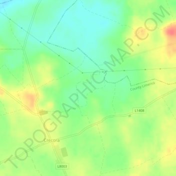
Cliquez sur la carte pour afficher l’altitude.
À propos de cette carte
Nom : Carte topographique Marlbrook, altitude, relief.
Altitude moyenne : 35 m
Altitude minimum : 12 m
Altitude maximum : 63 m
Autres cartes topographiques
Cliquez sur une carte pour visualiser sa topographie, son altitude et son relief.
Adare
Ireland > County Limerick > The Municipal District of Adare — Rathkeale
Adare, The Municipal District of Adare — Rathkeale, County Limerick, Munster, Ireland
Altitude moyenne : 12 m
Milltown Bridge
Ireland > County Limerick > The Municipal District of Adare — Rathkeale
Milltown Bridge, Dromard, The Municipal District of Adare — Rathkeale, County Limerick, Munster, V94 HF80, Ireland
Altitude moyenne : 29 m
Kildimo
Ireland > County Limerick > The Municipal District of Adare — Rathkeale
Kildimo, The Municipal District of Adare — Rathkeale, County Limerick, Munster, Ireland
Altitude moyenne : 10 m
Rathmore
Ireland > County Limerick > The Municipal District of Adare — Rathkeale
Rathmore, The Municipal District of Adare — Rathkeale, County Limerick, Munster, Ireland
Altitude moyenne : 56 m