
Carte topographique Ireland
Carte interactive
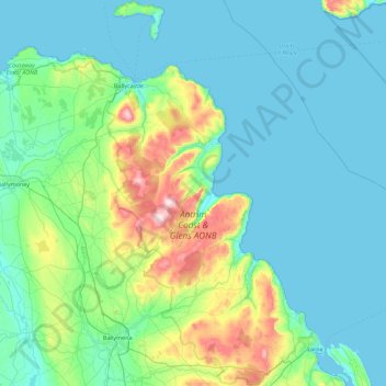
Cliquez sur la carte pour afficher l’altitude.
À propos de cette carte
Nom : Carte topographique Ireland, altitude, relief.
Altitude moyenne : 86 m
Altitude minimum : 0 m
Altitude maximum : 549 m
Autres cartes topographiques
Cliquez sur une carte pour visualiser sa topographie, son altitude et son relief.
Rathfeigh
Rathfeigh, Rathfeigh ED, The Municipal District of Ashbourne, County Meath, Leinster, Ireland
Altitude moyenne : 65 m
Dublin (Finglas)
Ireland > County Dublin > Dublin
Dublin (Finglas), Dublin, Fingal, County Dublin, Leinster, Ireland
Altitude moyenne : 48 m
Rathmore
Rathmore, Rathmore ED, Killarney Municipal District, County Kerry, Munster, P51 PT66, Ireland
Altitude moyenne : 149 m
Nenagh
Nenagh, The Municipal District of Nenagh, County Tipperary, Munster, Ireland
Altitude moyenne : 59 m
The Municipal District of Adare — Rathkeale
The Municipal District of Adare — Rathkeale, County Limerick, Munster, Ireland
Altitude moyenne : 74 m
Meenane
Meenane, Watergrasshill, Municipal District of Cobh, County Cork, Munster, Ireland
Altitude moyenne : 173 m
Ballinasloe
Ballinasloe, County Galway, Connacht, Ireland
Altitude moyenne : 46 m
Carrowmore
Carrowmore, Kilmacowen ED, Sligo Municipal Borough District, County Sligo, Connacht, Ireland
Altitude moyenne : 36 m
Curraghboy
Curraghboy, Castleffrench ED, Ballinasloe Municipal District, County Galway, Connacht, Ireland
Altitude moyenne : 53 m
Corballis
Corballis, Donabate DED 1986, Fingal, County Dublin, Leinster, Ireland
Altitude moyenne : 3 m
Murreagh
Murreagh, Kenmare Municipal District, County Kerry, Munster, V92 P681, Ireland
Altitude moyenne : 37 m
Clooney
Clooney, Killaloe Municipal District, County Clare, Munster, Ireland
Altitude moyenne : 57 m
Grand Canal - Barrow Line
Ireland > County Kildare > Athy
Grand Canal - Barrow Line, Athy, Athy Urban West ED, The Municipal District of Athy, County Kildare, Leinster, R14 EH50, Ireland
Altitude moyenne : 60 m
Ballyconneely
Ballyconneely, Conamara Municipal District, County Galway, Connacht, Ireland
Altitude moyenne : 8 m
Burrow
Burrow, Kilcumeragh ED, The Municipal District of Tullamore, County Offaly, Leinster, Ireland
Altitude moyenne : 64 m
Dough
Dough, Crookhaven ED, West Cork, County Cork, Munster, Ireland
Altitude moyenne : 35 m
Dunfanaghy
Dunfanaghy, County Donegal, F92 H0CY, Ireland
Altitude moyenne : 23 m
Doonbeg
Doonbeg, West Clare Municipal District, County Clare, Munster, Ireland
Altitude moyenne : 11 m
Dooaghs
Dooaghs, Caragh ED, Kenmare Municipal District, County Kerry, Munster, Ireland
Altitude moyenne : 10 m
Murvagh Lower
Murvagh Lower, Ballintra ED, Donegal Municipal District, County Donegal, Ireland
Altitude moyenne : 2 m
Cruit Island
Cruit Island, Rutland ED, Glenties Municipal District, County Donegal, Ireland
Altitude moyenne : 6 m
Rosses Upper
Rosses Upper, Drumcliff West ED, Sligo Municipal Borough District, County Sligo, Connacht, Ireland
Altitude moyenne : 8 m
Rosses Point
Rosses Point, County Sligo, Connacht, Ireland
Altitude moyenne : 8 m
Stradbally
Stradbally, Stradbally ED, The Municipal District of Graiguecullen — Portarlington, County Laois, Leinster, Ireland
Altitude moyenne : 92 m
Castlegregory
Castlegregory, Kenmare Municipal District, County Kerry, Munster, V92 F6NX, Ireland
Altitude moyenne : 17 m
Ballyliffin
Ballyliffin, Inishowen Municipal District, County Donegal, Ulster, Ireland
Altitude moyenne : 76 m
Kilgarvan
Kilgarvan, Kilgarvan ED, Kenmare Municipal District, County Kerry, Munster, Ireland
Altitude moyenne : 71 m
Ballyjamesduff Municipal District
Ballyjamesduff Municipal District, County Cavan, Ulster, Ireland
Altitude moyenne : 100 m
Carrowbunnaun
Carrowbunnaun, Knockaree ED, Sligo Municipal Borough District, County Sligo, Connacht, Ireland
Altitude moyenne : 36 m
Croaghross
Ireland > County Donegal > Letterkenny
Croaghross, Greenfort ED, Letterkenny, County Donegal, Ireland
Altitude moyenne : 25 m
Lisfannan
Lisfannan, Burt ED, Inishowen Municipal District, County Donegal, Ireland
Altitude moyenne : 48 m
Illanoona
Illanoona, Corraun Achill ED, Westport-Belmullet Municipal District, County Mayo, Connacht, Ireland
Altitude moyenne : 20 m
Lahinch
Lahinch, Ennistimon ED, West Clare Municipal District, County Clare, Munster, Ireland
Altitude moyenne : 35 m
Bartragh
Bartragh, Castleconor West Electoral Division, Ballymote-Tubbercurry Municipal District, County Sligo, Connacht, Ireland
Altitude moyenne : 6 m
Donabate
Donabate, Semple Woods, Donabate DED 1986, Fingal, County Dublin, Leinster, Ireland
Altitude moyenne : 6 m
Bandon
Bandon, The Municipal District of Bandon-Kinsale, County Cork, Munster, Ireland
Altitude moyenne : 59 m
Mount Lucas
Mount Lucas, Esker ED, The Municipal District of Edenderry, County Offaly, Leinster, R35 XW10, Ireland
Altitude moyenne : 76 m
Termonfeckin
Termonfeckin, Termonfeckin ED, The Borough District of Drogheda, County Louth, Leinster, Ireland
Altitude moyenne : 16 m
Bearlough
Bearlough, Toomour ED, Ballymote-Tubbercurry Municipal District, County Sligo, Connacht, Ireland
Altitude moyenne : 72 m
Baltray
Baltray, Termonfeckin ED, The Borough District of Drogheda, County Louth, Leinster, Ireland
Altitude moyenne : 3 m