Géolocaliser

Carte topographique Drogheda

Carte interactive

Cliquez sur la carte pour afficher l’altitude.

À propos de cette carte

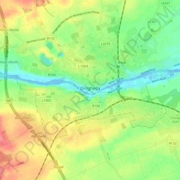
Nom : Carte topographique Drogheda, altitude, relief.

Lieu : Drogheda, County Louth, Leinster, Ireland (53.69442 -6.39292 53.73425 -6.29826)

Altitude moyenne : 34 m

Altitude minimum : -1 m

Altitude maximum : 77 m

Autres cartes topographiques

Cliquez sur une carte pour visualiser sa topographie, son altitude et son relief.

Termonfeckin

Ireland > County Louth

Termonfeckin, Termonfeckin ED, The Borough District of Drogheda, County Louth, Leinster, Ireland

Altitude moyenne : 16 m

Baltray

Ireland > County Louth

Baltray, Termonfeckin ED, The Borough District of Drogheda, County Louth, Leinster, Ireland

Altitude moyenne : 3 m

Dundalk

Ireland > County Louth

Dundalk, County Louth, Leinster, Ireland

Altitude moyenne : 13 m

Tullyallen

Ireland > County Louth

Tullyallen, St. Peter's ED, The Borough District of Drogheda, County Louth, Leinster, Ireland

Altitude moyenne : 49 m

The Borough District of Drogheda

Ireland > County Louth

The Borough District of Drogheda, County Louth, Leinster, Ireland

Altitude moyenne : 50 m

Dundalk Poor Law Union

Ireland > County Louth

Dundalk Poor Law Union, County Louth, Leinster, Ireland

Altitude moyenne : 74 m

Drogheda

Ireland > County Louth > Drogheda

Drogheda, The Borough District of Drogheda, County Louth, Leinster, A92DKR0, Ireland

Altitude moyenne : 38 m

The Municipal District of Dundalk

Ireland > County Louth

The Municipal District of Dundalk, County Louth, Leinster, Ireland

Altitude moyenne : 68 m

Dundalk

Ireland > County Louth > Dundalk

Dundalk, The Municipal District of Dundalk, County Louth, Leinster, A91 RC44, Ireland

Altitude moyenne : 16 m

Bellurgan

Ireland > County Louth

Bellurgan, Ballymascanlan ED, The Municipal District of Dundalk, County Louth, Leinster, Ireland

Altitude moyenne : 52 m

Coole

Ireland > County Louth

Coole, Ardee Rural ED, The Municipal District of Ardee, County Louth, Leinster, Ireland

Altitude moyenne : 32 m

Galroostown

Ireland > County Louth

Galroostown, Termonfeckin ED, The Borough District of Drogheda, County Louth, Leinster, Ireland

Altitude moyenne : 66 m

Carlingford

Ireland > County Louth > Carlingford

Carlingford, The Municipal District of Dundalk, County Louth, Leinster, A91 TRR6, Ireland

Altitude moyenne : 84 m