

Carte topographique Uinta Mountains
Cliquez sur la carte pour afficher l’altitude.
Uinta Mountains
The high Uintas were extensively glaciated during the last ice age, and most of the large stream valleys on both the north and south sides of the range held long valley glaciers. However, despite reaching to over 13,500 feet (4,110 m) in elevation, the climate today is sufficiently dry that no glaciers survived even before the rapid current glacial retreat began in the middle nineteenth century. The Uintas are the most poleward mountain range in the world to reach over 13,000 feet (4,000 m) without modern glaciers, and are in fact the highest mountain range in the contiguous United States with no modern glaciers. Permafrost occurs at elevations above 10,000 feet (3,000 m) and at times forms large rock glaciers.
À propos de cette carte
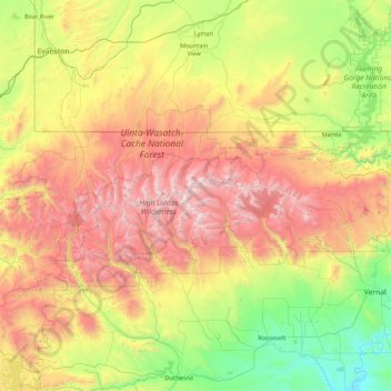
Nom : Carte topographique Uinta Mountains, altitude, relief.
Lieu : Uinta Mountains, Utah, United States (40.47516 -111.19949 41.08660 -109.45679)
Altitude moyenne : 2’363 m
Altitude minimum : 1’420 m
Altitude maximum : 4’098 m
Autres cartes topographiques
Cliquez sur une carte pour visualiser sa topographie, son altitude et son relief.
Salt Lake City
United States > Utah > Salt Lake County
Salt Lake City's topography is characterized by a striking contrast between its flat valley floor and the surrounding rugged mountains. The city is situated in the Salt Lake Valley, with an average elevation of approximately 4,237 feet above sea level, making it one of the higher major cities in the United…
Altitude moyenne : 1’592 m
Brian Head
United States > Utah > Iron County
The community, at an elevation of 9,800 feet (3,000 m) above sea level, is the highest town in Utah. It is located on State Route 143 and is east of Interstate 15. Brian Head is approximately three miles north of Cedar Breaks National Monument.
Altitude moyenne : 3’031 m
Eagle Mountain
United States > Utah > Utah County
Eagle Mountain's climate varies drastically between the northeastern Ranches area and the southwestern City Center area. Despite being further south than Salt Lake City, both areas have cooler temperatures due to sitting at a higher elevation. The Ranches section of the city has slightly milder temperatures…
Altitude moyenne : 1’589 m
Zion National Park
United States > Utah > Washington County
The 8,726-foot (2,660 m) summit of Horse Ranch Mountain is the highest point in the park; the lowest point is the 3,666-foot (1,117 m) elevation of Coal Pits Wash, creating a relief of about 5,100 feet (1,600 m).
Altitude moyenne : 1’877 m
Saratoga Springs
United States > Utah > Utah County
Saratoga Springs is a city in Utah County, Utah, United States. The elevation is 4,505 feet. It is part of the Provo–Orem, Utah Metropolitan Statistical Area. The city is a relatively new development along the northwestern shores of Utah Lake. It was incorporated on December 31, 1997 and has been growing…
Altitude moyenne : 1’495 m
Logan
United States > Utah > Cache County
The city lies near the eastern edge of Cache Valley on the western slopes of the Bear River Mountains. Mount Logan rises to an elevation of 9,710 feet (2,960 m) immediately to the east, and south of Logan Canyon. The eastern portions of the city are constructed on top of shelf-like "benches", late Pleistocene…
Altitude moyenne : 1’498 m
Cedar City
United States > Utah > Iron County
Cedar City is located in the southeast Great Basin and is approximately 20 miles (32 km) north of the northeastern edge of the Mojave Desert. Its elevation of 5,846 feet (1,782 m) gives it a somewhat cooler climate compared to the nearby St. George region, though it retains cultural ties to the city —for…
Altitude moyenne : 1’975 m
St. George
United States > Utah > Washington County
The St. George valley occasionally receives wet or slushy snowfall in the winter, but what accumulates usually melts off by the mid-to-late morning; the normal seasonal snowfall is 1.4 inches (3.6 cm). The earliest snowfall was measured on October 29, 1971, and the latest on April 11, 1927. The record…
Altitude moyenne : 933 m

Wasatch Range
The range's highest point — 11,928 feet (3,636 m) — is Mount Nebo, a triple peak rising above Nephi, at the southern end of the range. In some places the mountains rise steeply from the valley's base elevation of 4,330 feet (1,320 m) to over 11,000 feet (3,400 m). Other notable peaks include Mount…
Altitude moyenne : 1’882 m

Park City
United States > Utah > Summit County
In the summertime, many valley residents of the Wasatch Front visit the town to escape high temperatures. Park City is usually cooler than Salt Lake City as it lies mostly higher than 7,000 feet (2,100 m) above sea level, while Salt Lake City is situated at an elevation of about 4,300 feet (1,300 m).
Altitude moyenne : 2’290 m
Utah County
Utah Valley lies at the center of the county, lined by the mountains of the Wasatch Range on the east. Utah Lake occupies a large part of the valley. The elevation ranges from 4,487 feet (1,368 m) above sea level at the lake to 11,928 feet (3,636 m) at the peak of Mount Nebo.
Altitude moyenne : 2’016 m

Tooele County
Tooele County lies on the west side of Utah. Its west border abuts the east border of the state of Nevada. Its northeast border abuts the Great Salt Lake. Three significant mountain ranges run north–south through the county. Its east boundary line is delineated by the crestline of the Oquirrh Mountains,…
Altitude moyenne : 1’463 m
Great Salt Lake
The Great Salt Lake differs in elevation between the south and north parts. The causeway for the Lucin Cutoff divides the lake into two parts. The water-surface elevation of the south part of the lake is usually 0.5 to 2 feet (15–61 cm) higher than that of the north part because most of the inflow to the…
Altitude moyenne : 1’350 m
Cache County
Cache County lies on the north edge of Utah. Its north border abuts the south border of the state of Idaho. On the western edge of the county are the Wellsville Mountains and on the eastern edge are the Bear River Mountains, both northern branches of the Wasatch Range. The Cache Valley reaches north to the…
Altitude moyenne : 1’906 m
Weber County
The county extends from high in the Wasatch Range in the east into a portion of the Great Salt Lake to the west, where the county's elongated point exists. The Weber and Ogden rivers and their tributaries run through its valleys. The Weber County Surveyor's office divides the county into two regions, the…
Altitude moyenne : 1’722 m
Davis County
The Great Salt Lake is surrounded by marshland and mudflats, and lies at an average elevation of approximately 4,200 feet (1,300 m), varying depending on the water level, which can lead to drastic changes in the lake size due to its shallowness. Davis County includes Antelope Island, the lake's largest island.…
Altitude moyenne : 1’430 m

Emery County
In 1853 John W. Gunnison, an Army Topographical Engineer came through Castle Valley, plotting a railroad route. He was commissioned for this assignment by the US Secretary of War Jefferson Davis. He left detailed descriptions of his travels and carefully laid out his route through Castle Valley. Gunnison's…
Altitude moyenne : 1’958 m

Bears Ears National Monument
The monument is named Bears Ears for a pair of buttes that rise to elevations over 8,900 feet (2,700 m) and 9,000 feet (2,700 m), which is more than 2,000 feet (610 m) above Utah state routes 95 and 261. The monument includes the area around the Bears Ears formation and adjacent land to the southeast along the…
Altitude moyenne : 1’716 m
Juab County
Juab County lies on the west side of Utah. Its west border abuts the east border of the state of Nevada. Its planar areas consist of rugged, arid semi-arable fine-grain soil, with hills and low mountains. Its eastern border is loosely defined by the ridgeline of an arm of the Wasatch Mountains. The terrain…
Altitude moyenne : 1’647 m
Uintah County
Uintah County lies on the east side of Utah. Its eastern border abuts the western border of the state of Colorado. The Green River flows southwestward through the central part of the county and forms the lower part of Uintah County's border with Duchesne County. Two miles south of Ouray, Utah, it is joined by…
Altitude moyenne : 2’055 m
Washington County
Most of the population is centered in the south-central part of the county near the Arizona border around St. George. Most national shopping, dining, and hospitality chains are located here, along with several local businesses. The climate of this section of the county is typical of the Mojave Desert in which…
Altitude moyenne : 1’550 m
Rich County
The southern half of Bear Lake and the Bear Lake Valley lies on the northern edge of the county. The Bear River Valley lies in most of the eastern portion of the county. The elevation of these valleys is close to 6,000 feet (1,800 m), and the rest of the county is covered by mountains, including the Bear River…
Altitude moyenne : 2’148 m


San Juan County
The Blue (Abajo) Mountains and the La Sal Mountains exceed 12,000 feet (3,700 m) in elevation. Both ranges are covered with lush forests, contrasting the scenery below. The elevation change within the county is from nearly 13,000 feet (4,000 m) in the La Sal Mountains to 3,000 feet (910 m) at Lake Powell, a…
Altitude moyenne : 1’739 m
Summit County
The county's mean elevation is 8,388 feet (2,557 m) above sea level, which is the second-highest (after Taos County, New Mexico) of any county outside Colorado. Owing to its proximity to Salt Lake City, Park City has acquired a reputation as an upscale getaway, bringing new development to the area.
Altitude moyenne : 2’323 m




Millard County
Pahvant Valley in Millard County has several ancient lava flows and extinct volcanoes, known as the Black Rock Desert volcanic field, including the "Black Rock" lava flow. About 17 miles (27 km) southwest of Delta, near Black Rock's northwest perimeter is a feature named the "Great Stone Face", which protrudes…
Altitude moyenne : 1’726 m

Beaver County
The Tushar Mountains lies on the eastern boundary of the county, reaching to 12,000 feet (3,700 m) in elevation and providing water for the farming communities of Beaver and Manderfield. To the west, barren desert valleys typify the scenery, separated by mountains lightly forested with junipers.
Altitude moyenne : 1’843 m
Ogden
United States > Utah > Weber County
According to the United States Census Bureau, the city has an area of 26.6 square miles (69.0 km2), all land. Elevations in the city range from about 4,300 to 5,000 feet (1,300 to 1,500 m) above sea level.
Altitude moyenne : 1’498 m
Provo
United States > Utah > Utah County
Provo lies in the Utah Valley at an elevation of 4,549 feet (1,387 m). According to the United States Census Bureau, the city has an area of 44.2 square miles (114.4 km2), of which 41.7 square miles (107.9 km2) is land and 2.5 square miles (6.5 km2), or 5.66%, is water.
Altitude moyenne : 1’728 m
Park City
United States > Utah > Summit County
In the summertime, many valley residents of the Wasatch Front visit the town to escape high temperatures. Park City is usually cooler than Salt Lake City as it lies mostly higher than 7,000 feet (2,100 m) above sea level, while Salt Lake City is situated at an elevation of about 4,300 feet (1,300 m).
Altitude moyenne : 2’290 m
Logan Canyon
United States > Utah > Cache County
Logan Canyon is a canyon in the western United States in northeastern Utah, which cuts its way through the Bear River Mountains, a branch of the Wasatch Range. It is popular for both summer and winter activities, especially rock-climbing, hiking, camping, fishing, snowmobiling, and skiing, at the Beaver…
Altitude moyenne : 1’780 m
Moab
United States > Utah > Grand County
Moab is just south of the Colorado River, at an elevation of 4,025 feet (1,227 m) on the Colorado Plateau. It is 18 miles (29 km) west of the Utah/Colorado state line. Via U.S. Route 191, it is 31 miles (50 km) south of Interstate 70 at Crescent Junction, and it is 54 miles (87 km) north of Monticello. Via…
Altitude moyenne : 1’357 m
Richfield
United States > Utah > Sevier County
Richfield experiences a cold semi-arid climate (Köppen BSk) with four distinct seasons. Winter high temperatures average in the 30s and 40s with many milder days; low temperatures average in the teens and twenties, with a few mornings starting near or below zero. Snowfall is common, but usually melts in a day…
Altitude moyenne : 1’659 m
Zion National Park
United States > Utah > Washington County
The 8,726-foot (2,660 m) summit of Horse Ranch Mountain is the highest point in the park; the lowest point is the 3,666-foot (1,117 m) elevation of Coal Pits Wash, creating a relief of about 5,100 feet (1,600 m).
Altitude moyenne : 1’877 m
Virgin
United States > Utah > Washington County
Virgin is a town in Washington County, Utah, United States. The population was 670 at the 2020 census. The first settlement at Virgin was made in 1858. It is located along the Virgin River (for which it is named), and not far from Zion National Park. The elevation is 3,606 feet (1,099 m). It lies on State…
Altitude moyenne : 1’251 m
Delta
United States > Utah > Millard County
Delta experiences a cold semi-arid climate (Köppen BSk) with hot summers and cold winters. Because of Delta's altitude and aridity, temperatures drop quickly after sunset, especially in the summer. Winters are cold. Daytime highs in the winter are usually above freezing, but nighttime lows drop well below…
Altitude moyenne : 1’417 m
Monticello
United States > Utah > San Juan County
Monticello is located at the base of the Abajo Mountains, or the Blue Mountains, which are part of the Manti-La Sal National Forest. The elevation of Monticello is 7,069 feet (2,155 m). From Monticello, a tree formation on the Blue Mountains can be seen, which resembles a horse's head and neck, which can be…
Altitude moyenne : 2’145 m

St. George
United States > Utah > Washington County
The St. George valley occasionally receives wet or slushy snowfall in the winter, but what accumulates usually melts off by the mid-to-late morning; the normal seasonal snowfall is 1.4 inches (3.6 cm). The earliest snowfall was measured on October 29, 1971, and the latest on April 11, 1927. The record…
Altitude moyenne : 933 m
West Jordan
United States > Utah > Salt Lake County
West Jordan is a city in Salt Lake County, Utah, United States. It is a suburb of Salt Lake City and has a mixed economy. According to the 2020 Census, the city had a population of 116,961, placing it as the third most populous in the state. The city occupies the southwest end of the Salt Lake Valley at an…
Altitude moyenne : 1’372 m
Alta
United States > Utah > Salt Lake County
Alta experiences a high altitude humid continental climate (Köppen Dfb), which borders on a subalpine climate (Dfc), due to its high elevation. Due to its proximity to the Great Salt Lake, the town receives very heavy snows, averaging over 507 inches (12.9 m) per year. During the very wet season of 1982/1983,…
Altitude moyenne : 2’912 m
Murray
United States > Utah > Salt Lake County
According to the United States Census Bureau, the city has a total area of 9.6 square miles (24.9 km2), all land. Murray is located in the heart of the Salt Lake Valley. The city is nearly built out with a broad mix of commercial, residential and industrial uses. The topography is generally gentle, sloping…
Altitude moyenne : 1’321 m
Draper
United States > Utah > Salt Lake County
Draper's climate is roughly identical to other Salt Lake City suburbs. However, due to being further away from the Great Salt Lake, varied elevation, and from the downtown urban heat island effect, Draper experiences a slightly drier winter and more extremes in temperatures.
Altitude moyenne : 1’570 m
Brigham City
United States > Utah > Box Elder County
According to the United States Census Bureau, the city has a total area of 24.2 square miles (62.6 km2), of which 23.8 square miles (61.7 km2) is land and 0.35 square miles (0.9 km2), or 1.40%, is water. It lies at an elevation of 4,315 feet (1,315 m).
Altitude moyenne : 1’529 m
Delicate Arch
United States > Utah > Grand County
Delicate Arch is one of the main tourist draws in Arches National Park. The parking lot at the Delicate Arch Trailhead, although large, fills up quickly on most days. The trail to Delicate Arch is 3 miles (4.8 kilometer) round trip with an elevation change of 480 feet (146 meters). The trail is well defined…
Altitude moyenne : 1’409 m
Panguitch
United States > Utah > Garfield County
Panguitch has a cool semi-arid climate (Köppen BSk) with summers featuring hot afternoons and cold mornings, and cold, dry winters. The high altitude and relatively high latitude means that mornings are cold throughout the year and freezing for most of it: between 1971 and 2000 an average of 227.7 mornings…
Altitude moyenne : 2’043 m


Orem
United States > Utah > Utah County
Orem is located at 40°17′56″N 111°41′47″W / 40.29889°N 111.69639°W / 40.29889; -111.69639 (40.298753, -111.696486). Situated in a high desert, with an average elevation of 4,756 feet. According to the United States Census Bureau, the city has a total area of 18.4 square miles (48 km2), all…
Altitude moyenne : 1’458 m
Taylorsville
United States > Utah > Salt Lake County
The land on which Taylorsville is located is part of an interconnected alluvial plain that was formed by the wearing down of the Wasatch and Oquirrh Mountains to the east and west. Beneath the surface, Taylorsville sits on more than a kilometer of unconsolidated rock, sand, and clay. The inactive Taylorsville…
Altitude moyenne : 1’325 m