
Carte topographique Delicate Arch
Carte interactive
Cliquez sur la carte pour afficher l’altitude.
À propos de cette carte
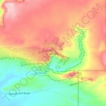
Nom : Carte topographique Delicate Arch, altitude, relief.
Altitude moyenne : 1’409 m
Altitude minimum : 1’309 m
Altitude maximum : 1’490 m
Delicate Arch is one of the main tourist draws in Arches National Park. The parking lot at the Delicate Arch Trailhead, although large, fills up quickly on most days. The trail to Delicate Arch is 3 miles (4.8 kilometer) round trip with an elevation change of 480 feet (146 meters). The trail is well defined for the first 1/2 mile, then does a steep incline over open rock. There is a narrow ledge for the last 200 yards (183 meter) before reaching the arch.
Autres cartes topographiques
Cliquez sur une carte pour visualiser sa topographie, son altitude et son relief.
Moab
United States > Utah > Grand County
Moab, Grand County, Utah, 84532, United States
Altitude moyenne : 1’357 m
Westwater
United States > Utah > Grand County
Westwater, Grand County, Utah, United States
Altitude moyenne : 1’349 m
Cisco
United States > Utah > Grand County
Cisco, Grand County, Utah, 84515, United States
Altitude moyenne : 1’334 m
Rectory
United States > Utah > Grand County
Rectory, Grand County, Utah, United States
Altitude moyenne : 1’527 m
Thompson Springs
United States > Utah > Grand County
Thompson Springs, Grand County, Utah, 84540, United States
Altitude moyenne : 1’583 m
Arches National Park
United States > Utah > Grand County
Arches National Park, Grand County, Utah, United States
Altitude moyenne : 1’476 m
Colorado River
United States > Utah > Grand County > Moab
Colorado River, Moab, Grand County, Utah, United States
Altitude moyenne : 1’668 m
Castle Valley
United States > Utah > Grand County
Castle Valley, Grand County, Utah, United States
Altitude moyenne : 1’610 m
Cottonwood Point
United States > Utah > Grand County
Cottonwood Point, Grand County, Utah, United States
Altitude moyenne : 2’346 m
La Sal Mountains Viewpoint
United States > Utah > Grand County
La Sal Mountains Viewpoint, Main Park Road, Grand County, Utah, 84532-2134, United States
Altitude moyenne : 1’347 m