
Carte topographique Cottonwood Point
Carte interactive
Cliquez sur la carte pour afficher l’altitude.
À propos de cette carte
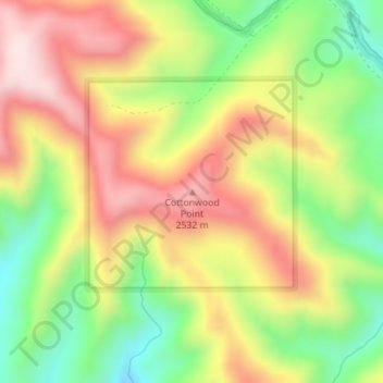
Nom : Carte topographique Cottonwood Point, altitude, relief.
Lieu : Cottonwood Point, Grand County, Utah, United States (39.15075 -109.60184 39.15085 -109.60174)
Altitude moyenne : 2’346 m
Altitude minimum : 2’118 m
Altitude maximum : 2’576 m
Autres cartes topographiques
Cliquez sur une carte pour visualiser sa topographie, son altitude et son relief.
Moab
United States > Utah > Grand County
Moab, Grand County, Utah, 84532, United States
Altitude moyenne : 1’357 m
Westwater
United States > Utah > Grand County
Westwater, Grand County, Utah, United States
Altitude moyenne : 1’349 m
Cisco
United States > Utah > Grand County
Cisco, Grand County, Utah, 84515, United States
Altitude moyenne : 1’334 m
Rectory
United States > Utah > Grand County
Rectory, Grand County, Utah, United States
Altitude moyenne : 1’527 m
Delicate Arch
United States > Utah > Grand County
Delicate Arch, Delicate Arch Trail, Grand County, Utah, United States
Altitude moyenne : 1’409 m
Thompson Springs
United States > Utah > Grand County
Thompson Springs, Grand County, Utah, 84540, United States
Altitude moyenne : 1’583 m
Arches National Park
United States > Utah > Grand County
Arches National Park, Grand County, Utah, United States
Altitude moyenne : 1’476 m
Colorado River
United States > Utah > Grand County > Moab
Colorado River, Moab, Grand County, Utah, United States
Altitude moyenne : 1’668 m
Castle Valley
United States > Utah > Grand County
Castle Valley, Grand County, Utah, United States
Altitude moyenne : 1’610 m
La Sal Mountains Viewpoint
United States > Utah > Grand County
La Sal Mountains Viewpoint, Main Park Road, Grand County, Utah, 84532-2134, United States
Altitude moyenne : 1’347 m