
Carte topographique Brian Head
Carte interactive
Cliquez sur la carte pour afficher l’altitude.
À propos de cette carte
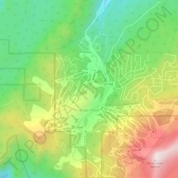
Nom : Carte topographique Brian Head, altitude, relief.
Lieu : Brian Head, Iron County, Utah, 84719, United States (37.67689 -112.86086 37.71835 -112.81505)
Altitude moyenne : 3’031 m
Altitude minimum : 2’729 m
Altitude maximum : 3’449 m
The community, at an elevation of 9,800 feet (3,000 m) above sea level, is the highest town in Utah. It is located on State Route 143 and is east of Interstate 15. Brian Head is approximately three miles north of Cedar Breaks National Monument.
Autres cartes topographiques
Cliquez sur une carte pour visualiser sa topographie, son altitude et son relief.
Cedar City
United States > Utah > Iron County
Cedar City, Iron County, Utah, United States
Altitude moyenne : 1’975 m
The Three Peaks
United States > Utah > Iron County
The Three Peaks, Iron County, Utah, United States
Altitude moyenne : 1’789 m
Cedar Breaks
United States > Utah > Iron County
Cedar Breaks, Iron County, Utah, United States
Altitude moyenne : 2’843 m
Newcastle
United States > Utah > Iron County
Newcastle, Iron County, Utah, United States
Altitude moyenne : 1’640 m
Cedar City
United States > Utah > Iron County > Cedar City > Cedar City
Cedar City, Iron County, Utah, 84720, United States
Altitude moyenne : 2’087 m
Beryl
United States > Utah > Iron County
Beryl, Iron County, Utah, United States
Altitude moyenne : 1’573 m
Enoch
United States > Utah > Iron County
Enoch, Iron County, Utah, United States
Altitude moyenne : 1’769 m
Strawberry Point
United States > Utah > Iron County
Strawberry Point, Iron County, Utah, 84772, United States
Altitude moyenne : 2’436 m
Kanarraville
United States > Utah > Iron County
Kanarraville, Iron County, Utah, 84742, United States
Altitude moyenne : 1’721 m
Parowan
United States > Utah > Iron County
Parowan, Iron County, Utah, 84761, United States
Altitude moyenne : 2’002 m