
Carte topographique Logan Canyon
Carte interactive
Cliquez sur la carte pour afficher l’altitude.
À propos de cette carte
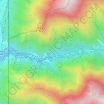
Nom : Carte topographique Logan Canyon, altitude, relief.
Lieu : Logan Canyon, Cache County, Utah, 84322, United States (41.73367 -111.77968 41.75367 -111.75968)
Altitude moyenne : 1’780 m
Altitude minimum : 1’428 m
Altitude maximum : 2’253 m
Logan Canyon is a canyon in the western United States in northeastern Utah, which cuts its way through the Bear River Mountains, a branch of the Wasatch Range. It is popular for both summer and winter activities, especially rock-climbing, hiking, camping, fishing, snowmobiling, and skiing, at the Beaver Mountain ski resort. The canyon rises to an elevation of approximately 7,800 feet (2,400 m) above sea level, after a vertical climb of about 2,900 feet (880 m). Just beyond the summit is a steep road leading into Bear Lake Valley and scenic overlooks that provide views of deep blue Bear Lake. The western terminus is at Logan in Cache County and the eastern terminus is at Garden City in Rich County.
Autres cartes topographiques
Cliquez sur une carte pour visualiser sa topographie, son altitude et son relief.
Logan
United States > Utah > Cache County
Logan, Cache County, Utah, United States
Altitude moyenne : 1’498 m
Trenton
United States > Utah > Cache County
Trenton, Cache County, Utah, 84338, United States
Altitude moyenne : 1’392 m
Benson
United States > Utah > Cache County
Benson, Cache County, Utah, United States
Altitude moyenne : 1’442 m
Peter
United States > Utah > Cache County > Petersboro
Peter, Petersboro, Cache County, Utah, United States
Altitude moyenne : 1’445 m
Lewiston
United States > Utah > Cache County
Lewiston, Cache County, Utah, 84320, United States
Altitude moyenne : 1’376 m
Hyrum
United States > Utah > Cache County
Hyrum, Cache County, Utah, 84319, United States
Altitude moyenne : 1’439 m
Clarkston
United States > Utah > Cache County
Clarkston, Cache County, Utah, 84305, United States
Altitude moyenne : 1’498 m
River Heights
United States > Utah > Cache County
River Heights, Cache County, Utah, United States
Altitude moyenne : 1’395 m
Mendon
United States > Utah > Cache County
Mendon, Cache County, Utah, United States
Altitude moyenne : 1’399 m
Smithfield
United States > Utah > Cache County
Smithfield, Cache County, Utah, 84335, United States
Altitude moyenne : 1’404 m
Mount Pisgah
United States > Utah > Cache County
Mount Pisgah, Cache County, Utah, United States
Altitude moyenne : 1’862 m
Nibley
United States > Utah > Cache County
Nibley, Cache County, Utah, United States
Altitude moyenne : 1’428 m
Logan River
United States > Utah > Cache County
Logan River, Cache County, Utah, United States
Altitude moyenne : 1’919 m
Providence Canyon
United States > Utah > Cache County
Providence Canyon, Cache County, Utah, 84332, United States
Altitude moyenne : 1’829 m
Wellsville
United States > Utah > Cache County
Wellsville, Cache County, Utah, 84339, United States
Altitude moyenne : 1’545 m
Logan
United States > Utah > Cache County > Logan > Logan
Logan, Cache County, Utah, 84321, United States
Altitude moyenne : 1’419 m
Hyde Park
United States > Utah > Cache County
Hyde Park, Cache County, Utah, 84318, United States
Altitude moyenne : 1’418 m
North Logan
United States > Utah > Cache County
North Logan, Cache County, Utah, 84341, United States
Altitude moyenne : 1’487 m
Hyrum
United States > Utah > Cache County > Hyrum > Hyrum
Hyrum, Cache County, Utah, 84319-1660, United States
Altitude moyenne : 1’439 m
Peter Sinks
United States > Utah > Cache County
Peter Sinks, Cache County, Utah, United States
Altitude moyenne : 2’555 m
Providence
United States > Utah > Cache County
Providence, Cache County, Utah, 84332, United States
Altitude moyenne : 1’434 m
James Peak
United States > Utah > Cache County
James Peak, Cache County, Utah, United States
Altitude moyenne : 2’550 m