
Carte topographique Kaski
Carte interactive
Cliquez sur la carte pour afficher l’altitude.
À propos de cette carte
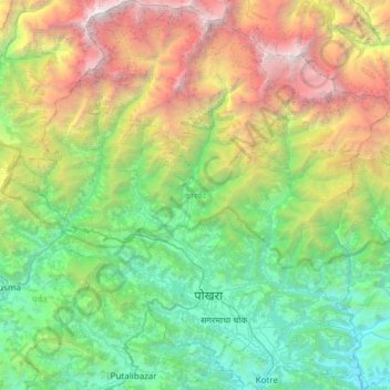
Nom : Carte topographique Kaski, altitude, relief.
Lieu : Kaski, Gandaki Province, Nepal (28.07773 83.69944 28.61295 84.27848)
Altitude moyenne : 2’565 m
Altitude minimum : 381 m
Altitude maximum : 8’006 m
The district, with Pokhara as its district headquarter, covers an area of 2,017 square km and had a total population of 492,098 according to 2011 Census. This district lies at the centroid point of the country. The altitude of Kaski district ranges from 450 meters the lowest land to 8091 meters the highest point in the Himalaya range. Kaski District politically has One Metropolitan City, 4 Gaupalika and 3 electoral sectors.
Autres cartes topographiques
Cliquez sur une carte pour visualiser sa topographie, son altitude et son relief.
Sarangkot
Nepal > Gandaki Province > Kaski > Pokhara
Sarangkot, Pokhara, Kaski, Gandaki Province, 00799, Nepal
Altitude moyenne : 1’139 m
Malika
Nepal > Gandaki Province > Myagdi
Malika, Myagdi, Gandaki Province, 33208, Nepal
Altitude moyenne : 2’161 m
Phedikhola
Nepal > Gandaki Province > Syangja
Phedikhola, Phedhikhola-01, Phedhikhola, Syangja, Gandaki Province, 33808, Nepal
Altitude moyenne : 1’193 m
Nyak
Nepal > Gandaki Province > Gorkha
Nyak, Chum Nubri, Gorkha, Gandaki Province, Nepal
Altitude moyenne : 2’320 m
Chame
Nepal > Gandaki Province > Manang
Chame, Manang, Gandaki Province, Nepal
Altitude moyenne : 4’025 m
Chum Nubri
Nepal > Gandaki Province > Gorkha
Chum Nubri, Gorkha, Gandaki Province, Nepal
Altitude moyenne : 4’445 m
Muktinath
Nepal > Gandaki Province > Mustang > Ranipauwa
Muktinath, Barhagaun Muktikhsetra-01, Ranipauwa, Barhagaun Muktikhsetra, Mustang, Gandaki Province, 33100, Nepal
Altitude moyenne : 3’965 m
Kihun
Nepal > Gandaki Province > Tanahun
Kihun, Bhimad, Tanahun, Gandaki Province, Nepal
Altitude moyenne : 842 m
Poon Hill
Nepal > Gandaki Province > Myagdi > Ghorepani
Poon Hill, Ghorepani, Annapurna, Myagdi, Gandaki Province, 33200, Nepal
Altitude moyenne : 2’873 m
Larjung
Nepal > Gandaki Province > Mustang
Larjung, Thasang, Mustang, Gandaki Province, Nepal
Altitude moyenne : 2’764 m
Annapurna Conservation Area
Nepal > Gandaki Province > Manang
Annapurna Conservation Area, Neshyang-08, Neshyang, Manang, Gandaki Province, Nepal
Altitude moyenne : 4’339 m
Phewa Lake
Nepal > Gandaki Province > Kaski > Pokhara
Phewa Lake, Pokhara-06, Pokhara, Kaski, Gandaki Province, Nepal
Altitude moyenne : 884 m
Barpak
Nepal > Gandaki Province > Gorkha
Barpak, Sulikot, Gorkha, Gandaki Province, Nepal
Altitude moyenne : 1’714 m
Annapurna
Nepal > Gandaki Province > Kaski
Annapurna, Kaski, Gandaki Province, 33711, Nepal
Altitude moyenne : 2’974 m
Kapuche Glacier Lake
Nepal > Gandaki Province > Kaski
Kapuche Glacier Lake, Parche - Namarjung, Madi-02, Madi, Kaski, Gandaki Province, Nepal
Altitude moyenne : 2’908 m
Pokhara
Nepal > Gandaki Province > Kaski
Pokhara, Kaski, Gandaki Province, Nepal
Altitude moyenne : 1’203 m
Sundarbazar
Nepal > Gandaki Province > Lamjung
Sundarbazar, Lamjung, Gandaki Province, Nepal
Altitude moyenne : 958 m
Byas
Nepal > Gandaki Province > Tanahun
Byas, Tanahun, Gandaki Province, Nepal
Altitude moyenne : 664 m
Dhaulagiri
Nepal > Gandaki Province > Myagdi
Dhaulagiri, Myagdi, Gandaki Province, Nepal
Altitude moyenne : 7’321 m