
Carte topographique Mustang
Carte interactive
Cliquez sur la carte pour afficher l’altitude.
À propos de cette carte
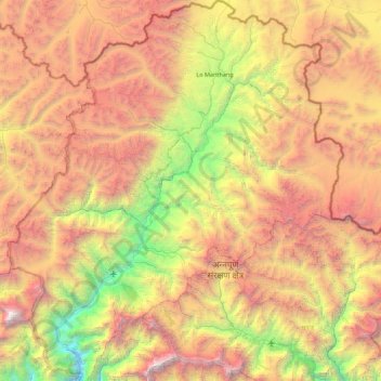
Nom : Carte topographique Mustang, altitude, relief.
Lieu : Mustang, Gandaki Province, 33100, Nepal (28.56450 83.47900 29.33125 84.25171)
Altitude moyenne : 4’938 m
Altitude minimum : 2’335 m
Altitude maximum : 8’142 m
The district is a part of Gandaki Province in northern Nepal, straddles the Himalayas and extends northward onto the Tibetan Plateau. The district is one of the remotest areas in Nepal and is second in terms of the sparsity of population. The elevation ranges from 1,372 to 8,167 meters (Mount Dhaulagiri, the 7th highest mountain in the world), with several peaks above 7,000 meters.
Autres cartes topographiques
Cliquez sur une carte pour visualiser sa topographie, son altitude et son relief.
Sarangkot
Nepal > Gandaki Province > Kaski > Pokhara
Sarangkot, Pokhara, Kaski, Gandaki Province, 00799, Nepal
Altitude moyenne : 1’139 m
Malika
Nepal > Gandaki Province > Myagdi
Malika, Myagdi, Gandaki Province, 33208, Nepal
Altitude moyenne : 2’161 m
Phedikhola
Nepal > Gandaki Province > Syangja
Phedikhola, Phedhikhola-01, Phedhikhola, Syangja, Gandaki Province, 33808, Nepal
Altitude moyenne : 1’193 m
Nyak
Nepal > Gandaki Province > Gorkha
Nyak, Chum Nubri, Gorkha, Gandaki Province, Nepal
Altitude moyenne : 2’320 m
Chame
Nepal > Gandaki Province > Manang
Chame, Manang, Gandaki Province, Nepal
Altitude moyenne : 4’025 m
Chum Nubri
Nepal > Gandaki Province > Gorkha
Chum Nubri, Gorkha, Gandaki Province, Nepal
Altitude moyenne : 4’445 m
Muktinath
Nepal > Gandaki Province > Mustang > Ranipauwa
Muktinath, Barhagaun Muktikhsetra-01, Ranipauwa, Barhagaun Muktikhsetra, Mustang, Gandaki Province, 33100, Nepal
Altitude moyenne : 3’965 m
Kihun
Nepal > Gandaki Province > Tanahun
Kihun, Bhimad, Tanahun, Gandaki Province, Nepal
Altitude moyenne : 842 m
Poon Hill
Nepal > Gandaki Province > Myagdi > Ghorepani
Poon Hill, Ghorepani, Annapurna, Myagdi, Gandaki Province, 33200, Nepal
Altitude moyenne : 2’873 m
Larjung
Nepal > Gandaki Province > Mustang
Larjung, Thasang, Mustang, Gandaki Province, Nepal
Altitude moyenne : 2’764 m
Annapurna Conservation Area
Nepal > Gandaki Province > Manang
Annapurna Conservation Area, Neshyang-08, Neshyang, Manang, Gandaki Province, Nepal
Altitude moyenne : 4’339 m
Phewa Lake
Nepal > Gandaki Province > Kaski > Pokhara
Phewa Lake, Pokhara-06, Pokhara, Kaski, Gandaki Province, Nepal
Altitude moyenne : 884 m
Barpak
Nepal > Gandaki Province > Gorkha
Barpak, Sulikot, Gorkha, Gandaki Province, Nepal
Altitude moyenne : 1’714 m
Annapurna
Nepal > Gandaki Province > Kaski
Annapurna, Kaski, Gandaki Province, 33711, Nepal
Altitude moyenne : 2’974 m
Kapuche Glacier Lake
Nepal > Gandaki Province > Kaski
Kapuche Glacier Lake, Parche - Namarjung, Madi-02, Madi, Kaski, Gandaki Province, Nepal
Altitude moyenne : 2’908 m
Pokhara
Nepal > Gandaki Province > Kaski
Pokhara, Kaski, Gandaki Province, Nepal
Altitude moyenne : 1’203 m
Sundarbazar
Nepal > Gandaki Province > Lamjung
Sundarbazar, Lamjung, Gandaki Province, Nepal
Altitude moyenne : 958 m
Byas
Nepal > Gandaki Province > Tanahun
Byas, Tanahun, Gandaki Province, Nepal
Altitude moyenne : 664 m
Dhaulagiri
Nepal > Gandaki Province > Myagdi
Dhaulagiri, Myagdi, Gandaki Province, Nepal
Altitude moyenne : 7’321 m