
Carte topographique Syangja
Carte interactive
Cliquez sur la carte pour afficher l’altitude.
À propos de cette carte
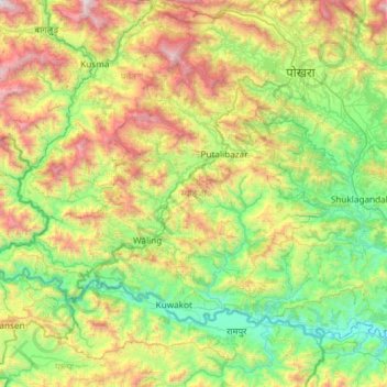
Nom : Carte topographique Syangja, altitude, relief.
Lieu : Syangja, Gandaki Province, Nepal (27.86777 83.43972 28.22117 84.03140)
Altitude moyenne : 1’012 m
Altitude minimum : 267 m
Altitude maximum : 2’626 m
Syangja District (Nepali: स्याङ्जा जिल्ला; Listen (help·info)), a part of Gandaki Province, is one of the seventy-seven districts of Nepal. The district, with Syangja bazaar (a small town) as its district headquarters, covers an area of 1,164 km2 (449 sq mi) and had a population of 289,148 It lies in the hilly region at an altitude ranging from about 300 meters along the banks of Kaligandaki river up to a couple of thousands meters above the sea level. It lies at about latitude 28°4'60 North and longitude 83°52'0 East.
Autres cartes topographiques
Cliquez sur une carte pour visualiser sa topographie, son altitude et son relief.
Sarangkot
Nepal > Gandaki Province > Kaski > Pokhara
Sarangkot, Pokhara, Kaski, Gandaki Province, 00799, Nepal
Altitude moyenne : 1’139 m
Malika
Nepal > Gandaki Province > Myagdi
Malika, Myagdi, Gandaki Province, 33208, Nepal
Altitude moyenne : 2’161 m
Phedikhola
Nepal > Gandaki Province > Syangja
Phedikhola, Phedhikhola-01, Phedhikhola, Syangja, Gandaki Province, 33808, Nepal
Altitude moyenne : 1’193 m
Nyak
Nepal > Gandaki Province > Gorkha
Nyak, Chum Nubri, Gorkha, Gandaki Province, Nepal
Altitude moyenne : 2’320 m
Chame
Nepal > Gandaki Province > Manang
Chame, Manang, Gandaki Province, Nepal
Altitude moyenne : 4’025 m
Chum Nubri
Nepal > Gandaki Province > Gorkha
Chum Nubri, Gorkha, Gandaki Province, Nepal
Altitude moyenne : 4’445 m
Muktinath
Nepal > Gandaki Province > Mustang > Ranipauwa
Muktinath, Barhagaun Muktikhsetra-01, Ranipauwa, Barhagaun Muktikhsetra, Mustang, Gandaki Province, 33100, Nepal
Altitude moyenne : 3’965 m
Kihun
Nepal > Gandaki Province > Tanahun
Kihun, Bhimad, Tanahun, Gandaki Province, Nepal
Altitude moyenne : 842 m
Poon Hill
Nepal > Gandaki Province > Myagdi > Ghorepani
Poon Hill, Ghorepani, Annapurna, Myagdi, Gandaki Province, 33200, Nepal
Altitude moyenne : 2’873 m
Larjung
Nepal > Gandaki Province > Mustang
Larjung, Thasang, Mustang, Gandaki Province, Nepal
Altitude moyenne : 2’764 m
Annapurna Conservation Area
Nepal > Gandaki Province > Manang
Annapurna Conservation Area, Neshyang-08, Neshyang, Manang, Gandaki Province, Nepal
Altitude moyenne : 4’339 m
Phewa Lake
Nepal > Gandaki Province > Kaski > Pokhara
Phewa Lake, Pokhara-06, Pokhara, Kaski, Gandaki Province, Nepal
Altitude moyenne : 884 m
Barpak
Nepal > Gandaki Province > Gorkha
Barpak, Sulikot, Gorkha, Gandaki Province, Nepal
Altitude moyenne : 1’714 m
Annapurna
Nepal > Gandaki Province > Kaski
Annapurna, Kaski, Gandaki Province, 33711, Nepal
Altitude moyenne : 2’974 m
Kapuche Glacier Lake
Nepal > Gandaki Province > Kaski
Kapuche Glacier Lake, Parche - Namarjung, Madi-02, Madi, Kaski, Gandaki Province, Nepal
Altitude moyenne : 2’908 m
Pokhara
Nepal > Gandaki Province > Kaski
Pokhara, Kaski, Gandaki Province, Nepal
Altitude moyenne : 1’203 m
Sundarbazar
Nepal > Gandaki Province > Lamjung
Sundarbazar, Lamjung, Gandaki Province, Nepal
Altitude moyenne : 958 m
Byas
Nepal > Gandaki Province > Tanahun
Byas, Tanahun, Gandaki Province, Nepal
Altitude moyenne : 664 m
Dhaulagiri
Nepal > Gandaki Province > Myagdi
Dhaulagiri, Myagdi, Gandaki Province, Nepal
Altitude moyenne : 7’321 m