
Carte topographique Heideck
Carte interactive
Cliquez sur la carte pour afficher l’altitude.
À propos de cette carte
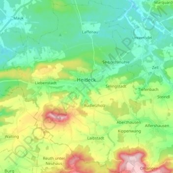
Nom : Carte topographique Heideck, altitude, relief.
Lieu : Heideck, Landkreis Roth, Bayern, 91180, Deutschland (49.08053 11.05187 49.17917 11.17200)
Altitude moyenne : 441 m
Altitude minimum : 365 m
Altitude maximum : 612 m
Die Stadt liegt im südlichen Mittelfranken etwa zwischen dem Rothsee und dem Brombachsee im Tal der Kleinen Roth auf einer Höhe von 407 m ü. NHN. Südlich des Stadtgebietes steigt das Gelände zum fränkischen Jura hin steil an und erreicht bei Schloßberg eine Höhe von 607 m ü. NHN. Südlich des Gemeindeteils Selingstadt verläuft die Europäische Hauptwasserscheide. Nördlich davon fließen alle Gewässer in die Nordsee, südlich davon ins Schwarze Meer.
Autres cartes topographiques
Cliquez sur une carte pour visualiser sa topographie, son altitude et son relief.
Weinsfeld
Deutschland > Bayern > Landkreis Roth > Hilpoltstein
Weinsfeld, Hilpoltstein, Landkreis Roth, Bayern, Deutschland
Altitude moyenne : 442 m
Poppenreuth
Deutschland > Bayern > Landkreis Roth > Kammerstein
Poppenreuth, Kammerstein, Landkreis Roth, Bayern, 91183, Deutschland
Altitude moyenne : 395 m
Wildenbergen
Deutschland > Bayern > Landkreis Roth > Kottensdorf
Wildenbergen, Kottensdorf, Rohr, Landkreis Roth, Bayern, 91189, Deutschland
Altitude moyenne : 380 m
Hagershof
Deutschland > Bayern > Landkreis Roth > Schwanstetten > Mittelhembach
Hagershof, Mittelhembach, Schwanstetten, Landkreis Roth, Bayern, 90596, Deutschland
Altitude moyenne : 342 m
Belmbrach
Deutschland > Bayern > Landkreis Roth > Roth
Belmbrach, Roth, Landkreis Roth, Bayern, 91154, Deutschland
Altitude moyenne : 362 m
Massenberg
Deutschland > Bayern > Landkreis Roth > Spalt
Massenberg, Spalt, Landkreis Roth, Bayern, 91174, Deutschland
Altitude moyenne : 435 m
Kleinabenberg
Deutschland > Bayern > Landkreis Roth > Abenberg
Kleinabenberg, Abenberg, Landkreis Roth, Bayern, 91183, Deutschland
Altitude moyenne : 390 m
Reckenricht
Deutschland > Bayern > Landkreis Roth > Allersberg
Reckenricht, Allersberg, Landkreis Roth, Bayern, 90584, Deutschland
Altitude moyenne : 420 m
Greding
Deutschland > Bayern > Landkreis Roth
Greding, Landkreis Roth, Bayern, 91171, Deutschland
Altitude moyenne : 488 m
Mauk
Deutschland > Bayern > Landkreis Roth
Mauk, Georgensgmünd, Landkreis Roth, Bayern, 91187, Deutschland
Altitude moyenne : 391 m
Hilpoltstein
Deutschland > Bayern > Landkreis Roth
Hilpoltstein, Landkreis Roth, Bayern, 91161, Deutschland
Altitude moyenne : 418 m
Igelsdorf
Deutschland > Bayern > Landkreis Roth
Igelsdorf, Rednitzhembach, Landkreis Roth, Bayern, 91186, Deutschland
Altitude moyenne : 343 m
Spalt
Deutschland > Bayern > Landkreis Roth
Spalt, Landkreis Roth, Bayern, 91174, Deutschland
Altitude moyenne : 421 m
Wassermungenau
Deutschland > Bayern > Landkreis Roth > Abenberg
Wassermungenau, Abenberg, Landkreis Roth, Bayern, Deutschland
Altitude moyenne : 400 m
Rothsee (Hauptsperre)
Deutschland > Bayern > Landkreis Roth > Roth > Haimpfarrich
Rothsee (Hauptsperre), Haimpfarrich, Roth, Landkreis Roth, Bayern, Deutschland
Altitude moyenne : 382 m
Kammerstein
Deutschland > Bayern > Landkreis Roth
Kammerstein, Landkreis Roth, Bayern, Deutschland
Altitude moyenne : 383 m
Rednitzhembach
Deutschland > Bayern > Landkreis Roth
Rednitzhembach, Landkreis Roth, Bayern, Deutschland
Altitude moyenne : 347 m
Allersberg
Deutschland > Bayern > Landkreis Roth > Allersberg > Allersberg
Allersberg, Landkreis Roth, Bayern, 90584, Deutschland
Altitude moyenne : 408 m
Thalmässing
Deutschland > Bayern > Landkreis Roth
Thalmässing, Landkreis Roth, Bayern, 91177, Deutschland
Altitude moyenne : 476 m
Rednitzhembach
Deutschland > Bayern > Landkreis Roth > Rednitzhembach > Rednitzhembach
Rednitzhembach, Landkreis Roth, Bayern, 91186, Deutschland
Altitude moyenne : 350 m
Haag
Deutschland > Bayern > Landkreis Roth > Haag
Haag, Kammerstein, Landkreis Roth, Bayern, 91126, Deutschland
Altitude moyenne : 379 m
Rothaurach
Deutschland > Bayern > Landkreis Roth > Roth > Rothaurach
Rothaurach, Roth, Landkreis Roth, Bayern, 91186, Deutschland
Altitude moyenne : 365 m
Petersgmünd
Deutschland > Bayern > Landkreis Roth
Petersgmünd, Georgensgmünd, Landkreis Roth, Bayern, 91166, Deutschland
Altitude moyenne : 368 m
Steinfurt
Deutschland > Bayern > Landkreis Roth > Spalt > Wasserzell > Steinfurt
Steinfurt, Wasserzell, Spalt, Landkreis Roth, Bayern, 91174, Deutschland
Altitude moyenne : 407 m
Schwanstetten
Deutschland > Bayern > Landkreis Roth
Schwanstetten, Landkreis Roth, Bayern, 90596, Deutschland
Altitude moyenne : 352 m
Oberheckenhofen
Deutschland > Bayern > Landkreis Roth > Oberheckenhofen
Oberheckenhofen, Georgensgmünd, Landkreis Roth, Bayern, 91166, Deutschland
Altitude moyenne : 371 m
Allersberg
Deutschland > Bayern > Landkreis Roth
Allersberg, Landkreis Roth, Bayern, 90584, Deutschland
Altitude moyenne : 406 m
Rohr
Deutschland > Bayern > Landkreis Roth > Rohr
Rohr, Landkreis Roth, Bayern, 91189, Deutschland
Altitude moyenne : 399 m
Wendelstein
Deutschland > Bayern > Landkreis Roth
Wendelstein, Landkreis Roth, Bayern, 90530, Deutschland
Altitude moyenne : 355 m
Georgensgmünd
Deutschland > Bayern > Landkreis Roth
Georgensgmünd, Landkreis Roth, Bayern, 91166, Deutschland
Altitude moyenne : 387 m
Büchenbach
Deutschland > Bayern > Landkreis Roth
Büchenbach, Landkreis Roth, Bayern, 91186, Deutschland
Altitude moyenne : 363 m
Mäbenberg
Deutschland > Bayern > Landkreis Roth > Georgensgmünd
Mäbenberg, Georgensgmünd, Landkreis Roth, Bayern, 91166, Deutschland
Altitude moyenne : 399 m
Laibstadt
Deutschland > Bayern > Landkreis Roth > Heideck
Laibstadt, Heideck, Landkreis Roth, Bayern, 91180, Deutschland
Altitude moyenne : 488 m
Abenberg
Deutschland > Bayern > Landkreis Roth
Abenberg, Landkreis Roth, Bayern, 91183, Deutschland
Altitude moyenne : 397 m