
Faire un don
Équipez-vous pour votre prochaine aventure :
En tant que Partenaire Amazon, ce site perçoit une commission sur les achats éligibles sans surcoût pour vous.
Carte topographique Igelsdorf
Cliquez sur la carte pour afficher l’altitude.
Faire un don
Équipez-vous pour votre prochaine aventure :
En tant que Partenaire Amazon, ce site perçoit une commission sur les achats éligibles sans surcoût pour vous.
Igelsdorf
Das Dorf liegt dreieinhalb Kilometer südlich von Schwabach auf einer Anhöhe zwischen den Tälern des südlich fließenden Mainbaches und der östlich verlaufenden Rednitz. Westlich befindet sich das ausgedehnte Waldgebiet Maisenlach.
Faire un don
Équipez-vous pour votre prochaine aventure :
En tant que Partenaire Amazon, ce site perçoit une commission sur les achats éligibles sans surcoût pour vous.
À propos de cette carte
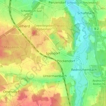
Nom : Carte topographique Igelsdorf, altitude, relief.
Altitude moyenne : 343 m
Altitude minimum : 313 m
Altitude maximum : 376 m
Faire un don
Équipez-vous pour votre prochaine aventure :
En tant que Partenaire Amazon, ce site perçoit une commission sur les achats éligibles sans surcoût pour vous.
Autres cartes topographiques
Cliquez sur une carte pour visualiser sa topographie, son altitude et son relief.
Spalt
Deutschland > Bayern > Landkreis Roth
Die Stadt hat eine Faschingstradition. Im Vorfeld der Fastnachtswoche finden drei Saumarktball genannte Faschingsbälle in der Spalter Stadthalle statt. Der Höhepunkt der Faschingszeit wird mit dem Unsinnigen Donnerstag eingeläutet, der in der Altstadt mit ihren Kneipen und Wirtshäusern stattfindet. Dem…
Altitude moyenne : 421 m
Rothsee (Hauptsperre)
Deutschland > Bayern > Landkreis Roth > Roth > Eichelburg
Durch ein Einlaufbauwerk am Hauptdamm fließen aus dem Main-Donau-Kanal maximal 21 m³/s zu, abgegeben werden maximal 15 m³/s Wasser. Das Kraftwerk Rothsee I nutzt das aus dem See abgegebene Wasser für zwei Turbinen: eine Durchströmturbine für maximal 1 m³/s Durchfluss, die bei niedrigen Abflüssen…
Altitude moyenne : 382 m
Greding
Deutschland > Bayern > Landkreis Roth
Die höchste Erhebung in der Gemeinde Greding ist der Euerwanger Bühl mit 595,3 m ü. NHN. Die niedrigste Höhe ist 379 m ü. NHN an der Stelle, an der die Schwarzach das Gemeindegebiet verlässt.
Altitude moyenne : 488 m
Faire un don
Équipez-vous pour votre prochaine aventure :
En tant que Partenaire Amazon, ce site perçoit une commission sur les achats éligibles sans surcoût pour vous.
Hilpoltstein
Deutschland > Bayern > Landkreis Roth
Hilpoltstein entwickelte sich zum Unterzentrum, erfüllt aber viele Funktionen eines Mittelzentrums. Am 2. September 2006 stellte eine Lokomotive vom Typ ES 64 U4 mit 357 km/h einen neuen Geschwindigkeits-Weltrekord für konventionelle Elektrolokomotiven im Gebiet der Stadt Hilpoltstein auf Höhe der…
Altitude moyenne : 418 m
Heideck
Deutschland > Bayern > Landkreis Roth
Die Stadt liegt im südlichen Mittelfranken etwa zwischen dem Rothsee und dem Brombachsee im Tal der Kleinen Roth auf einer Höhe von 407 m ü. NHN. Südlich des Stadtgebietes steigt das Gelände zum fränkischen Jura hin steil an und erreicht bei Schloßberg eine Höhe von 607 m ü. NHN. Südlich des…
Altitude moyenne : 441 m
Faire un don
Équipez-vous pour votre prochaine aventure :
En tant que Partenaire Amazon, ce site perçoit une commission sur les achats éligibles sans surcoût pour vous.
Kammerstein
Deutschland > Bayern > Landkreis Roth
Die Ortschaft Kammerstein liegt fünf Kilometer südwestlich von Schwabach unterhalb eines westlichen Ausläufers des Heidenberges auf eine Höhe von 410 m ü. NHN. Die Gemeinde liegt in etwa auf halbem Weg zwischen der Stadt Nürnberg und dem Fränkischen Seenland.
Altitude moyenne : 383 m
Abenberg
Deutschland > Bayern > Landkreis Roth
Die Stadt liegt rund 25 Kilometer südwestlich von Nürnberg und zehn Kilometer westlich der Kreisstadt Roth, am Nordrand des Fränkischen Seenlands, großräumig gesehen zwischen der Frankenhöhe im Nordwesten, Nürnberg im Norden und der Fränkischen Alb im Süden und Osten. Die kleinen Flussläufe im…
Altitude moyenne : 404 m
Faire un don
Équipez-vous pour votre prochaine aventure :
En tant que Partenaire Amazon, ce site perçoit une commission sur les achats éligibles sans surcoût pour vous.
Faire un don
Équipez-vous pour votre prochaine aventure :
En tant que Partenaire Amazon, ce site perçoit une commission sur les achats éligibles sans surcoût pour vous.
Thalmässing
Deutschland > Bayern > Landkreis Roth
Neben dem Jura zieht sich als zweite Anhöhe die Europäische Wasserscheide durch das Gemeindegebiet, welche die Flüsse entweder über die Donau ins Schwarze Meer oder über Main/Rhein in die Nordsee leitet.
Altitude moyenne : 476 m
Soos
Deutschland > Bayern > Landkreis Roth
Der 1,30 km² große Staatsforst liegt zwischen Rednitzhembach und Schwanstetten. Die Bundesstraße 2 verläuft hindurch. Am östlichen Rand befindet sich der Main-Donau-Kanal und die Schleuse Leerstetten. Mit einer Hubhöhe von 24,67 Metern zählt sie zu den höchsten Schleusen Europas.
Altitude moyenne : 346 m
Faire un don
Équipez-vous pour votre prochaine aventure :
En tant que Partenaire Amazon, ce site perçoit une commission sur les achats éligibles sans surcoût pour vous.
Rednitz
Deutschland > Bayern > Landkreis Roth
In Fürth fließt sie westlich an der Altstadt vorbei und vereinigt sich kurz danach auf einer Höhe von etwa 283 m ü. NHN mit der Pegnitz, die östlich am Fürther Stadtzentrum vorbei aus Richtung der Nürnberger Altstadt kommt, zur Regnitz.
Altitude moyenne : 368 m
Allersberg
Deutschland > Bayern > Landkreis Roth
Im Jahre 2014 gab es in der Gemeinde 1718 sozialversicherungspflichtige Arbeitsplätze. 3266 Einwohner standen in einem versicherungspflichtigen Beschäftigungsverhältnis, so dass die Zahl der Auspendler um 1555 Personen höher war als die der Einpendler. Im Jahre 2010 bestanden 75 landwirtschaftliche…
Altitude moyenne : 406 m
Faire un don
Équipez-vous pour votre prochaine aventure :
En tant que Partenaire Amazon, ce site perçoit une commission sur les achats éligibles sans surcoût pour vous.
Heideck
Deutschland > Bayern > Landkreis Roth
Die Stadt liegt im südlichen Mittelfranken etwa zwischen dem Rothsee und dem Brombachsee im Tal der Kleinen Roth auf einer Höhe von 407 m ü. NHN. Südlich des Stadtgebietes steigt das Gelände zum fränkischen Jura hin steil an und erreicht bei Schloßberg eine Höhe von 607 m ü. NHN. Südlich des…
Altitude moyenne : 441 m
Thalmässing
Deutschland > Bayern > Landkreis Roth
Neben dem Jura zieht sich als zweite Anhöhe die Europäische Wasserscheide durch das Gemeindegebiet, welche die Flüsse entweder über die Donau ins Schwarze Meer oder über Main/Rhein in die Nordsee leitet.
Altitude moyenne : 476 m
Faire un don
Équipez-vous pour votre prochaine aventure :
En tant que Partenaire Amazon, ce site perçoit une commission sur les achats éligibles sans surcoût pour vous.
Spalt
Deutschland > Bayern > Landkreis Roth
Die Stadt hat eine Faschingstradition. Im Vorfeld der Fastnachtswoche finden drei Saumarktball genannte Faschingsbälle in der Spalter Stadthalle statt. Der Höhepunkt der Faschingszeit wird mit dem Unsinnigen Donnerstag eingeläutet, der in der Altstadt mit ihren Kneipen und Wirtshäusern stattfindet. Dem…
Altitude moyenne : 421 m
Abenberg
Deutschland > Bayern > Landkreis Roth
Die Stadt liegt rund 25 Kilometer südwestlich von Nürnberg und zehn Kilometer westlich der Kreisstadt Roth, am Nordrand des Fränkischen Seenlands, großräumig gesehen zwischen der Frankenhöhe im Nordwesten, Nürnberg im Norden und der Fränkischen Alb im Süden und Osten. Die kleinen Flussläufe im…
Altitude moyenne : 397 m