
Carte topographique Hilpoltstein
Cliquez sur la carte pour afficher l’altitude.
Hilpoltstein
Hilpoltstein entwickelte sich zum Unterzentrum, erfüllt aber viele Funktionen eines Mittelzentrums. Am 2. September 2006 stellte eine Lokomotive vom Typ ES 64 U4 mit 357 km/h einen neuen Geschwindigkeits-Weltrekord für konventionelle Elektrolokomotiven im Gebiet der Stadt Hilpoltstein auf Höhe der Autobahn-Raststätte Hilpoltstein an der Schnellfahrstrecke Nürnberg–Ingolstadt auf.
À propos de cette carte
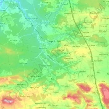
Nom : Carte topographique Hilpoltstein, altitude, relief.
Lieu : Hilpoltstein, Landkreis Roth, Bayern, 91161, Deutschland (49.12640 11.11503 49.21764 11.32773)
Altitude moyenne : 418 m
Altitude minimum : 331 m
Altitude maximum : 600 m
Autres cartes topographiques
Cliquez sur une carte pour visualiser sa topographie, son altitude et son relief.
Greding
Deutschland > Bayern > Landkreis Roth > Greding
Die höchste Erhebung in der Gemeinde Greding ist der Euerwanger Bühl mit 595,3 m ü. NHN. Die niedrigste Höhe ist 379 m ü. NHN an der Stelle, an der die Schwarzach das Gemeindegebiet verlässt.
Altitude moyenne : 491 m
Allersberg
Deutschland > Bayern > Landkreis Roth > Allersberg > Allersberg
Im Jahre 2014 gab es in der Gemeinde 1718 sozialversicherungspflichtige Arbeitsplätze. 3266 Einwohner standen in einem versicherungspflichtigen Beschäftigungsverhältnis, so dass die Zahl der Auspendler um 1555 Personen höher war als die der Einpendler. Im Jahre 2010 bestanden 75 landwirtschaftliche…
Altitude moyenne : 408 m
Igelsdorf
Deutschland > Bayern > Landkreis Roth
Das Dorf liegt dreieinhalb Kilometer südlich von Schwabach auf einer Anhöhe zwischen den Tälern des südlich fließenden Mainbaches und der östlich verlaufenden Rednitz. Westlich befindet sich das ausgedehnte Waldgebiet Maisenlach.
Altitude moyenne : 343 m
Hagershof
Deutschland > Bayern > Landkreis Roth > Schwanstetten > Mittelhembach
Altitude moyenne : 342 m
Esselberg
Deutschland > Bayern > Landkreis Roth > Greding
Ein Ritter ohne Kopf erscheint in der Mitternachtsstunde und reitet auf einem Schimmel im Tal und auf den Höhen umher. Sein Erscheinen bedeutet nahes Unheil. Zuletzt sollen ihn Bauern kurz vor dem Ersten Weltkrieg gesehen haben.
Altitude moyenne : 527 m
Röthenbach bei St. Wolfgang
Deutschland > Bayern > Landkreis Roth > Wendelstein
Altitude moyenne : 356 m
Heuberg
Deutschland > Bayern > Landkreis Roth > Hilpoltstein
Die älteste Ortsnamensform „Hegeberch“ zeigt, dass es sich bei der Siedlung um einen eingehegten Bereich auf einer Anhöhe handelte.
Altitude moyenne : 392 m
Steinfurt
Deutschland > Bayern > Landkreis Roth > Spalt > Wasserzell > Steinfurt
Altitude moyenne : 407 m
Rednitzhembach
Deutschland > Bayern > Landkreis Roth > Rednitzhembach > Rednitzhembach
Altitude moyenne : 350 m
Petersgmünd
Deutschland > Bayern > Landkreis Roth
Im Geographischen statistisch-topographischen Lexikon von Franken (1801) wird der Ort folgendermaßen beschrieben.
Altitude moyenne : 368 m