
Faire un don
Équipez-vous pour votre prochaine aventure :
En tant que Partenaire Amazon, ce site perçoit une commission sur les achats éligibles sans surcoût pour vous.
Carte topographique Belmbrach
Cliquez sur la carte pour afficher l’altitude.
Faire un don
Équipez-vous pour votre prochaine aventure :
En tant que Partenaire Amazon, ce site perçoit une commission sur les achats éligibles sans surcoût pour vous.
À propos de cette carte
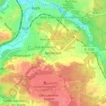
Nom : Carte topographique Belmbrach, altitude, relief.
Lieu : Belmbrach, Roth, Landkreis Roth, Bayern, 91154, Deutschland (49.20896 11.08102 49.24896 11.12102)
Altitude moyenne : 362 m
Altitude minimum : 326 m
Altitude maximum : 393 m
Faire un don
Équipez-vous pour votre prochaine aventure :
En tant que Partenaire Amazon, ce site perçoit une commission sur les achats éligibles sans surcoût pour vous.
Autres cartes topographiques
Cliquez sur une carte pour visualiser sa topographie, son altitude et son relief.
Rothsee (Hauptsperre)
Deutschland > Bayern > Landkreis Roth > Roth > Eichelburg
Durch ein Einlaufbauwerk am Hauptdamm fließen aus dem Main-Donau-Kanal maximal 21 m³/s zu, abgegeben werden maximal 15 m³/s Wasser. Das Kraftwerk Rothsee I nutzt das aus dem See abgegebene Wasser für zwei Turbinen: eine Durchströmturbine für maximal 1 m³/s Durchfluss, die bei niedrigen Abflüssen…
Altitude moyenne : 382 m