
Carte topographique Newport County
Carte interactive
Cliquez sur la carte pour afficher l’altitude.
À propos de cette carte
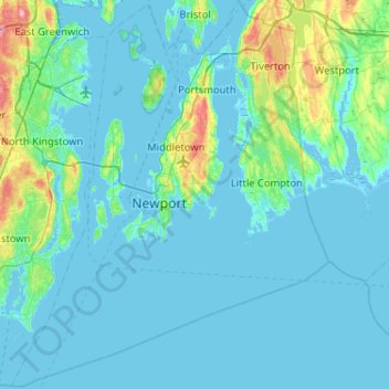
Nom : Carte topographique Newport County, altitude, relief.
Lieu : Newport County, Rhode Island, United States (41.30736 -71.50944 41.69050 -71.08857)
Altitude moyenne : 14 m
Altitude minimum : -7 m
Altitude maximum : 130 m
The county consists of Aquidneck Island, Conanicut Island, Prudence Island, and the easternmost portion of the state on the mainland. The highest point in the county is Pocasset Hill, 320 feet (98 m) above sea level, located in Tiverton. The lowest elevation is at sea level.
Autres cartes topographiques
Cliquez sur une carte pour visualiser sa topographie, son altitude et son relief.
Barrington
United States > Rhode Island > Bristol County
Barrington, Bristol County, Rhode Island, 02806, United States
Altitude moyenne : 4 m
Warwick
United States > Rhode Island > Kent County
Warwick, Kent County, Rhode Island, United States
Altitude moyenne : 16 m
Cumberland
United States > Rhode Island > Providence County
Cumberland, Providence County, Rhode Island, 02864, United States
Altitude moyenne : 76 m
Aquidneck Island
United States > Rhode Island > Newport County > Portsmouth
Aquidneck Island, Portsmouth, Newport County, Rhode Island, United States
Altitude moyenne : 13 m
Goat Island
United States > Rhode Island > Newport County > Newport
Goat Island, Newport, Newport County, Rhode Island, United States
Altitude moyenne : 2 m
Westerly
United States > Rhode Island > South County
Westerly, South County, Rhode Island, 02808, United States
Altitude moyenne : 19 m
Tiverton
United States > Rhode Island > Newport County
Tiverton, Newport County, Rhode Island, 02878, United States
Altitude moyenne : 31 m
South Kingstown
United States > Rhode Island > South County
South Kingstown, South County, Rhode Island, United States
Altitude moyenne : 30 m
Chopmist
United States > Rhode Island > Providence County > Scituate
Chopmist, Scituate, Providence County, Rhode Island, 02857, United States
Altitude moyenne : 175 m
Diamond Hill
United States > Rhode Island > Providence County > Cumberland
Diamond Hill, Cumberland, Providence County, Rhode Island, 02864, United States
Altitude moyenne : 80 m
Providence
United States > Rhode Island > Providence County
Providence, Providence County, Rhode Island, United States
Altitude moyenne : 19 m
Charlestown
United States > Rhode Island > South County
Charlestown, South County, Rhode Island, 02813, United States
Altitude moyenne : 22 m
Cranston
United States > Rhode Island > Providence County
Cranston, Providence County, Rhode Island, United States
Altitude moyenne : 27 m
Jamestown
United States > Rhode Island > Newport County
Jamestown, Newport County, Rhode Island, 02835, United States
Altitude moyenne : 8 m
Wakefield
United States > Rhode Island > South County > South Kingstown
Wakefield, South Kingstown, South County, Rhode Island, 02879, United States
Altitude moyenne : 23 m
West Warwick
United States > Rhode Island > Kent County
West Warwick, Kent County, Rhode Island, United States
Altitude moyenne : 59 m
East Providence
United States > Rhode Island > Providence County
East Providence, Providence County, Rhode Island, United States
Altitude moyenne : 12 m
Middletown
United States > Rhode Island > Newport County
Middletown, Newport County, Rhode Island, 02842, United States
Altitude moyenne : 19 m
Masonic - Shriners Family Center
United States > Rhode Island > Kent County > Warwick
Masonic - Shriners Family Center, Warwick, Kent County, Rhode Island, United States
Altitude moyenne : 7 m
James V. Turner Reservoir
United States > Rhode Island > Providence County > East Providence > Rumford
James V. Turner Reservoir, Rumford, East Providence, Providence County, Rhode Island, United States
Altitude moyenne : 14 m
Page Island
United States > Rhode Island > Providence County > Pascoag
Page Island, Pascoag, Providence County, Rhode Island, 02859, United States
Altitude moyenne : 124 m
West Warwick
United States > Rhode Island > Kent County
West Warwick, Kent County, Rhode Island, 02893, United States
Altitude moyenne : 60 m
Portsmouth
United States > Rhode Island > Newport County
Portsmouth, Newport County, Rhode Island, United States
Altitude moyenne : 19 m
Narragansett Town Beach
United States > Rhode Island > South County > Narragansett > Narragansett Pier
Narragansett Town Beach, Narragansett Beach, Narragansett Pier, Narragansett, South County, Rhode Island, United States
Altitude moyenne : 6 m
Pawtucket
United States > Rhode Island > Providence County
Pawtucket, Providence County, Rhode Island, United States
Altitude moyenne : 24 m
Narragansett Bay
United States > Rhode Island > Newport County
Narragansett Bay, Newport County, Rhode Island, 02783, United States
Altitude moyenne : 4 m
Bristol
United States > Rhode Island > Bristol County
Bristol, Bristol County, Rhode Island, 02809, United States
Altitude moyenne : 6 m
Coventry
United States > Rhode Island > Kent County
Coventry, Kent County, Rhode Island, United States
Altitude moyenne : 126 m
Central Falls
United States > Rhode Island > Providence County
Central Falls, Providence County, Rhode Island, United States
Altitude moyenne : 22 m
Little Compton
United States > Rhode Island > Newport County
Little Compton, Newport County, Rhode Island, United States
Altitude moyenne : 9 m
Hell's Half Acre
United States > Rhode Island > Kent County > West Greenwich
Hell's Half Acre, West Greenwich, Kent County, Rhode Island, 02822, United States
Altitude moyenne : 110 m
Warren
United States > Rhode Island > Bristol County
Warren, Bristol County, Rhode Island, 02885, United States
Altitude moyenne : 6 m
Roosevelt Lake
United States > Rhode Island > Providence County > Providence
Roosevelt Lake, Providence, Providence County, Rhode Island, United States
Altitude moyenne : 12 m
North Providence
United States > Rhode Island > Providence County
North Providence, Providence County, Rhode Island, 02911, United States
Altitude moyenne : 53 m
Woonsocket
United States > Rhode Island > Providence County
Woonsocket, Providence County, Rhode Island, 02895, United States
Altitude moyenne : 74 m
Cunliff Pond Dam
United States > Rhode Island > Providence County > Providence
Cunliff Pond Dam, Providence, Providence County, Rhode Island, 02905, United States
Altitude moyenne : 9 m
Green Hill Point
United States > Rhode Island > South County > South Kingstown > Green Hill
Green Hill Point, Green Hill, South Kingstown, South County, Rhode Island, United States
Altitude moyenne : 2 m
Providence River
United States > Rhode Island > Providence County > Providence
Providence River, Providence, Providence County, Rhode Island, 02903, United States
Altitude moyenne : 9 m
Block Island
United States > Rhode Island > South County > New Shoreham
Block Island, New Shoreham, South County, Rhode Island, 02807, United States
Altitude moyenne : 5 m
Prudence Island
United States > Rhode Island > Newport County > Portsmouth
Prudence Island, Portsmouth, Newport County, Rhode Island, United States
Altitude moyenne : 6 m
Newport
United States > Rhode Island > Newport County
Newport, Newport County, Rhode Island, 02840, United States
Altitude moyenne : 8 m
Narragansett
United States > Rhode Island > South County
Narragansett, South County, Rhode Island, 02882, United States
Altitude moyenne : 12 m
Crompton
United States > Rhode Island > Kent County > West Warwick
Crompton, West Warwick, Kent County, Rhode Island, 02893, United States
Altitude moyenne : 63 m
North Kingstown
United States > Rhode Island > South County
North Kingstown, South County, Rhode Island, United States
Altitude moyenne : 35 m
Misquamicut
United States > Rhode Island > Washington County > Westerly
Misquamicut, Westerly, Washington County, Rhode Island, 02891, United States
Altitude moyenne : 6 m
North Smithfield
United States > Rhode Island > Providence County > North Smithfield
North Smithfield, Providence County, Rhode Island, United States
Altitude moyenne : 96 m
Providence County
Providence County, Rhode Island, United States
Altitude moyenne : 108 m
Burrillville
United States > Rhode Island > Providence County
Burrillville, Providence County, Rhode Island, United States
Altitude moyenne : 155 m
Newton Swamp Management Area
United States > Rhode Island > South County > Westerly
Newton Swamp Management Area, McGowan Corners, Westerly, South County, Rhode Island, 02808, United States
Altitude moyenne : 22 m
South County
South County, Rhode Island, United States
Altitude moyenne : 30 m