
Carte topographique West Warwick
Carte interactive
Cliquez sur la carte pour afficher l’altitude.
À propos de cette carte
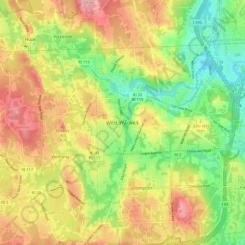
Nom : Carte topographique West Warwick, altitude, relief.
Lieu : West Warwick, Kent County, Rhode Island, United States (41.66613 -71.56215 41.74613 -71.48215)
Altitude moyenne : 59 m
Altitude minimum : 2 m
Altitude maximum : 117 m
Autres cartes topographiques
Cliquez sur une carte pour visualiser sa topographie, son altitude et son relief.
Warwick
United States > Rhode Island > Kent County
Warwick, Kent County, Rhode Island, United States
Altitude moyenne : 16 m
Masonic - Shriners Family Center
United States > Rhode Island > Kent County > Warwick
Masonic - Shriners Family Center, Warwick, Kent County, Rhode Island, United States
Altitude moyenne : 7 m
West Warwick
United States > Rhode Island > Kent County
West Warwick, Kent County, Rhode Island, 02893, United States
Altitude moyenne : 60 m
Coventry
United States > Rhode Island > Kent County
Coventry, Kent County, Rhode Island, United States
Altitude moyenne : 126 m
Hell's Half Acre
United States > Rhode Island > Kent County > West Greenwich
Hell's Half Acre, West Greenwich, Kent County, Rhode Island, 02822, United States
Altitude moyenne : 110 m
Crompton
United States > Rhode Island > Kent County > West Warwick
Crompton, West Warwick, Kent County, Rhode Island, 02893, United States
Altitude moyenne : 63 m
East Greenwich
United States > Rhode Island > Kent County
East Greenwich, Kent County, Rhode Island, 02818, United States
Altitude moyenne : 21 m
Greene
United States > Rhode Island > Kent County > Coventry > Greene
Greene, Coventry, Kent County, Rhode Island, 02827, United States
Altitude moyenne : 139 m
West Greenwich
United States > Rhode Island > Kent County
West Greenwich, Kent County, Rhode Island, 02817, United States
Altitude moyenne : 111 m