
Carte topographique Wakefield
Carte interactive
Cliquez sur la carte pour afficher l’altitude.
À propos de cette carte
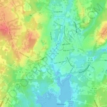
Nom : Carte topographique Wakefield, altitude, relief.
Altitude moyenne : 23 m
Altitude minimum : -4 m
Altitude maximum : 59 m
Autres cartes topographiques
Cliquez sur une carte pour visualiser sa topographie, son altitude et son relief.
Green Hill Point
United States > Rhode Island > South County > South Kingstown > Green Hill
Green Hill Point, Green Hill, South Kingstown, South County, Rhode Island, United States
Altitude moyenne : 2 m
Indian Lake
United States > Rhode Island > South County > South Kingstown
Indian Lake, South Kingstown, South County, Rhode Island, United States
Altitude moyenne : 32 m
Matunuck
United States > Rhode Island > South County > South Kingstown
Matunuck, South Kingstown, South County, Rhode Island, United States
Altitude moyenne : 5 m