
Carte topographique Narragansett Bay
Carte interactive
Cliquez sur la carte pour afficher l’altitude.
À propos de cette carte
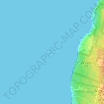
Nom : Carte topographique Narragansett Bay, altitude, relief.
Altitude moyenne : 4 m
Altitude minimum : -3 m
Altitude maximum : 32 m
Autres cartes topographiques
Cliquez sur une carte pour visualiser sa topographie, son altitude et son relief.
Aquidneck Island
United States > Rhode Island > Newport County > Portsmouth
Aquidneck Island, Portsmouth, Newport County, Rhode Island, United States
Altitude moyenne : 13 m
Goat Island
United States > Rhode Island > Newport County > Newport
Goat Island, Newport, Newport County, Rhode Island, United States
Altitude moyenne : 2 m
Tiverton
United States > Rhode Island > Newport County
Tiverton, Newport County, Rhode Island, 02878, United States
Altitude moyenne : 31 m
Jamestown
United States > Rhode Island > Newport County
Jamestown, Newport County, Rhode Island, 02835, United States
Altitude moyenne : 8 m
Middletown
United States > Rhode Island > Newport County
Middletown, Newport County, Rhode Island, 02842, United States
Altitude moyenne : 19 m
Portsmouth
United States > Rhode Island > Newport County
Portsmouth, Newport County, Rhode Island, United States
Altitude moyenne : 19 m
Little Compton
United States > Rhode Island > Newport County
Little Compton, Newport County, Rhode Island, United States
Altitude moyenne : 9 m
Prudence Island
United States > Rhode Island > Newport County > Portsmouth
Prudence Island, Portsmouth, Newport County, Rhode Island, United States
Altitude moyenne : 6 m
Newport
United States > Rhode Island > Newport County
Newport, Newport County, Rhode Island, 02840, United States
Altitude moyenne : 8 m
Pottersville
United States > Rhode Island > Newport County > Little Compton > Pottersville
Pottersville, Little Compton, Newport County, Rhode Island, 02837, United States
Altitude moyenne : 17 m