
Carte topographique Worley
Carte interactive
Cliquez sur la carte pour afficher l’altitude.
À propos de cette carte
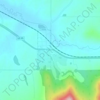
Nom : Carte topographique Worley, altitude, relief.
Lieu : Worley, Kootenai County, Idaho, United States (47.39512 -116.92215 47.40602 -116.91275)
Altitude moyenne : 830 m
Altitude minimum : 791 m
Altitude maximum : 1’030 m
Worley is located at 47°23′57″N 116°55′10″W / 47.39917°N 116.91944°W / 47.39917; -116.91944 (47.399124, -116.919410), at an elevation of 2,661 feet (811 m) above sea level.
Autres cartes topographiques
Cliquez sur une carte pour visualiser sa topographie, son altitude et son relief.
Coeur d'Alene
United States > Idaho > Kootenai County
Coeur d'Alene, Kootenai County, Idaho, 83815, United States
Altitude moyenne : 719 m
Post Falls
United States > Idaho > Kootenai County
Post Falls, Kootenai County, Idaho, 83854, United States
Altitude moyenne : 710 m
Hauser
United States > Idaho > Kootenai County
Hauser, Kootenai County, Idaho, United States
Altitude moyenne : 712 m
Bayview
United States > Idaho > Kootenai County
Bayview, Kootenai County, Idaho, United States
Altitude moyenne : 733 m
Farragut State Park
United States > Idaho > Kootenai County > Bayview
Farragut State Park, Bayview, Kootenai County, Idaho, United States
Altitude moyenne : 723 m
Fernan Saddle
United States > Idaho > Kootenai County
Fernan Saddle, Kootenai County, Idaho, United States
Altitude moyenne : 1’201 m
Lake Coeur d'Alene
United States > Idaho > Kootenai County > Harrison
Lake Coeur d'Alene, Harrison, Kootenai County, Idaho, United States
Altitude moyenne : 827 m
Hayden
United States > Idaho > Kootenai County
Hayden, Kootenai County, Idaho, United States
Altitude moyenne : 709 m
Fernan Lake
United States > Idaho > Kootenai County > Coeur d'Alene
Fernan Lake, Coeur d'Alene, Kootenai County, Idaho, United States
Altitude moyenne : 743 m
Athol
United States > Idaho > Kootenai County
Athol, Kootenai County, Idaho, United States
Altitude moyenne : 733 m
Cataldo
United States > Idaho > Kootenai County
Cataldo, Kootenai County, Idaho, 83839, United States
Altitude moyenne : 732 m
Bellgrove
United States > Idaho > Kootenai County
Bellgrove, Kootenai County, Idaho, United States
Altitude moyenne : 802 m
Silver Sands Beach
United States > Idaho > Kootenai County
Silver Sands Beach, Kootenai County, Idaho, United States
Altitude moyenne : 766 m
Hauser Lake
United States > Idaho > Kootenai County > Hauser
Hauser Lake, Hauser, Kootenai County, Idaho, United States
Altitude moyenne : 696 m
Hayden
United States > Idaho > Kootenai County
Hayden, Kootenai County, Idaho, 83835, United States
Altitude moyenne : 717 m
Cherry Hill
United States > Idaho > Kootenai County > Coeur d'Alene
Cherry Hill, Coeur d'Alene, Kootenai County, Idaho, 83815, United States
Altitude moyenne : 708 m
Dalton Gardens
United States > Idaho > Kootenai County
Dalton Gardens, Kootenai County, Idaho, United States
Altitude moyenne : 697 m
Rathdrum
United States > Idaho > Kootenai County
Rathdrum, Kootenai County, Idaho, United States
Altitude moyenne : 701 m
Spirit Lake
United States > Idaho > Kootenai County
Spirit Lake, Kootenai County, Idaho, 83869, United States
Altitude moyenne : 780 m
Harrison
United States > Idaho > Kootenai County
Harrison, Kootenai County, Idaho, United States
Altitude moyenne : 745 m