
Carte topographique Post Falls
Carte interactive
Cliquez sur la carte pour afficher l’altitude.
À propos de cette carte
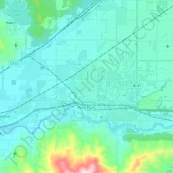
Nom : Carte topographique Post Falls, altitude, relief.
Lieu : Post Falls, Kootenai County, Idaho, 83854, United States (47.69255 -117.04179 47.75945 -116.85641)
Altitude moyenne : 710 m
Altitude minimum : 619 m
Altitude maximum : 1’295 m
Post Falls is located on the Rathdrum Prairie, along the Washington–Idaho border. It is bounded by Coeur d’Alene to the east, Stateline and the state of Washington to the west, and the Spokane River to the south. Post Falls is 20 miles (32 km) east of Spokane and approximately 100 miles (160 km) south of the Canada–United States border. The elevation of the city is 2,182 feet (665 m) above sea level.
Autres cartes topographiques
Cliquez sur une carte pour visualiser sa topographie, son altitude et son relief.
Coeur d'Alene
United States > Idaho > Kootenai County
Coeur d'Alene, Kootenai County, Idaho, 83815, United States
Altitude moyenne : 719 m
Hauser
United States > Idaho > Kootenai County
Hauser, Kootenai County, Idaho, United States
Altitude moyenne : 712 m
Bayview
United States > Idaho > Kootenai County
Bayview, Kootenai County, Idaho, United States
Altitude moyenne : 733 m
Farragut State Park
United States > Idaho > Kootenai County > Bayview
Farragut State Park, Bayview, Kootenai County, Idaho, United States
Altitude moyenne : 723 m
Fernan Saddle
United States > Idaho > Kootenai County
Fernan Saddle, Kootenai County, Idaho, United States
Altitude moyenne : 1’201 m
Lake Coeur d'Alene
United States > Idaho > Kootenai County > Harrison
Lake Coeur d'Alene, Harrison, Kootenai County, Idaho, United States
Altitude moyenne : 827 m
Fernan Lake
United States > Idaho > Kootenai County > Coeur d'Alene
Fernan Lake, Coeur d'Alene, Kootenai County, Idaho, United States
Altitude moyenne : 743 m
Hayden
United States > Idaho > Kootenai County
Hayden, Kootenai County, Idaho, United States
Altitude moyenne : 709 m
Cataldo
United States > Idaho > Kootenai County
Cataldo, Kootenai County, Idaho, 83839, United States
Altitude moyenne : 732 m
Athol
United States > Idaho > Kootenai County
Athol, Kootenai County, Idaho, United States
Altitude moyenne : 733 m
Bellgrove
United States > Idaho > Kootenai County
Bellgrove, Kootenai County, Idaho, United States
Altitude moyenne : 802 m
Silver Sands Beach
United States > Idaho > Kootenai County
Silver Sands Beach, Kootenai County, Idaho, United States
Altitude moyenne : 766 m
Hauser Lake
United States > Idaho > Kootenai County > Hauser
Hauser Lake, Hauser, Kootenai County, Idaho, United States
Altitude moyenne : 696 m
Hayden
United States > Idaho > Kootenai County
Hayden, Kootenai County, Idaho, 83835, United States
Altitude moyenne : 717 m
Cherry Hill
United States > Idaho > Kootenai County > Coeur d'Alene
Cherry Hill, Coeur d'Alene, Kootenai County, Idaho, 83815, United States
Altitude moyenne : 708 m
Dalton Gardens
United States > Idaho > Kootenai County
Dalton Gardens, Kootenai County, Idaho, United States
Altitude moyenne : 697 m
Rathdrum
United States > Idaho > Kootenai County
Rathdrum, Kootenai County, Idaho, United States
Altitude moyenne : 701 m
Spirit Lake
United States > Idaho > Kootenai County
Spirit Lake, Kootenai County, Idaho, 83869, United States
Altitude moyenne : 780 m
Harrison
United States > Idaho > Kootenai County
Harrison, Kootenai County, Idaho, United States
Altitude moyenne : 745 m
Worley
United States > Idaho > Kootenai County
Worley, Kootenai County, Idaho, United States
Altitude moyenne : 830 m