Géolocaliser

Carte topographique Fairseat

Cliquez sur la carte pour afficher l’altitude.

À propos de cette carte

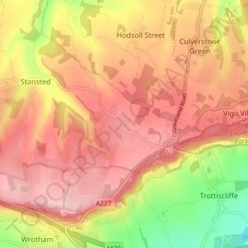
Nom : Carte topographique Fairseat, altitude, relief.

Lieu : Fairseat, Stansted, Tonbridge and Malling, Kent, England, TN15 7LU, United Kingdom (51.30853 0.30840 51.34853 0.34840)

Altitude moyenne : 164 m

Altitude minimum : 45 m

Altitude maximum : 237 m

Autres cartes topographiques

Cliquez sur une carte pour visualiser sa topographie, son altitude et son relief.

Stansted

United Kingdom > England > Kent > Tonbridge and Malling > Stansted

Altitude moyenne : 175 m

Hadlow

United Kingdom > England > Kent > Tonbridge and Malling > Hadlow

Altitude moyenne : 30 m

Hadlow

United Kingdom > England > Kent > Tonbridge and Malling

Altitude moyenne : 30 m

Ryarsh

United Kingdom > England > Kent > Tonbridge and Malling

Altitude moyenne : 57 m

Offham

United Kingdom > England > Kent > Tonbridge and Malling

Altitude moyenne : 96 m

Wrotham

United Kingdom > England > Kent > Tonbridge and Malling > Wrotham

Altitude moyenne : 145 m

Ditton

United Kingdom > England > Kent > Tonbridge and Malling > Ditton

Altitude moyenne : 37 m

Wouldham

United Kingdom > England > Kent > Tonbridge and Malling

Altitude moyenne : 63 m

Plaxtol

United Kingdom > England > Kent > Tonbridge and Malling

Altitude moyenne : 100 m

Ightham

United Kingdom > England > Kent > Tonbridge and Malling

Altitude moyenne : 121 m

Mereworth

United Kingdom > England > Kent > Tonbridge and Malling

Altitude moyenne : 104 m

Burham

United Kingdom > England > Kent > Tonbridge and Malling > Burham

Altitude moyenne : 58 m

Medway

United Kingdom > England > Kent > Tonbridge and Malling > Tonbridge

Altitude moyenne : 26 m

Équipez-vous pour votre prochaine aventure :

🧴Répulsifs anti-insectes - Protection contre moustiques et tiques
🔥Réchaud de camping compact - Préparez vos repas chauds partout, même par vent fort
🧣Tour de cou multifonction - Protège du froid, du vent ou du soleil selon vos besoins
📢Sifflet de secours - Pour signaler votre position en cas de brouillard ou d'accident
📱Support Smartphone VTT - Gardez vos cartes topographiques numériques visibles sur votre guidon

En tant que Partenaire Amazon, ce site perçoit une commission sur les achats éligibles sans surcoût pour vous.