
Faire un don
Équipez-vous pour votre prochaine aventure :
En tant que Partenaire Amazon, ce site perçoit une commission sur les achats éligibles sans surcoût pour vous.
Carte topographique Mereworth
Cliquez sur la carte pour afficher l’altitude.
Faire un don
Équipez-vous pour votre prochaine aventure :
En tant que Partenaire Amazon, ce site perçoit une commission sur les achats éligibles sans surcoût pour vous.
À propos de cette carte
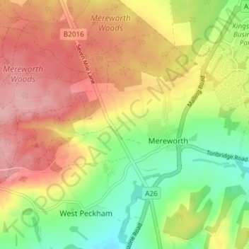
Nom : Carte topographique Mereworth, altitude, relief.
Lieu : Mereworth, Tonbridge and Malling, Kent, England, United Kingdom (51.24536 0.33672 51.27875 0.39777)
Altitude moyenne : 104 m
Altitude minimum : 37 m
Altitude maximum : 167 m
Faire un don
Équipez-vous pour votre prochaine aventure :
En tant que Partenaire Amazon, ce site perçoit une commission sur les achats éligibles sans surcoût pour vous.
Autres cartes topographiques
Cliquez sur une carte pour visualiser sa topographie, son altitude et son relief.
Ightham Common
United Kingdom > England > Kent > Tonbridge and Malling > Ightham
Altitude moyenne : 145 m
Faire un don
Équipez-vous pour votre prochaine aventure :
En tant que Partenaire Amazon, ce site perçoit une commission sur les achats éligibles sans surcoût pour vous.
Barden Lake
United Kingdom > England > Kent > Tonbridge and Malling > Tonbridge
Altitude moyenne : 33 m
Holborough Lakes
United Kingdom > England > Kent > Tonbridge and Malling > Snodland
Altitude moyenne : 32 m
Faire un don
Équipez-vous pour votre prochaine aventure :
En tant que Partenaire Amazon, ce site perçoit une commission sur les achats éligibles sans surcoût pour vous.
Beltring
United Kingdom > England > Kent > Tonbridge and Malling > East Peckham
Altitude moyenne : 15 m
Kit's Coty
United Kingdom > England > Kent > Tonbridge and Malling > Bluebell Hill
Altitude moyenne : 102 m
Royal British Legion Village
United Kingdom > England > Kent > Tonbridge and Malling
Altitude moyenne : 33 m
Faire un don
Équipez-vous pour votre prochaine aventure :
En tant que Partenaire Amazon, ce site perçoit une commission sur les achats éligibles sans surcoût pour vous.
Pratling Street
United Kingdom > England > Kent > Tonbridge and Malling > Aylesford > Pratling Street
Altitude moyenne : 49 m
Bradbourne
United Kingdom > England > Kent > Tonbridge and Malling > East Malling
Altitude moyenne : 28 m
Faire un don
Équipez-vous pour votre prochaine aventure :
En tant que Partenaire Amazon, ce site perçoit une commission sur les achats éligibles sans surcoût pour vous.
Faire un don
Équipez-vous pour votre prochaine aventure :
En tant que Partenaire Amazon, ce site perçoit une commission sur les achats éligibles sans surcoût pour vous.