
Carte topographique Louisiana
Carte interactive
Cliquez sur la carte pour afficher l’altitude.
À propos de cette carte
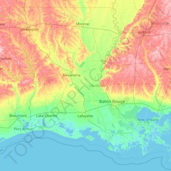
Nom : Carte topographique Louisiana, altitude, relief.
Lieu : Louisiana, United States (28.85429 -94.04319 33.01959 -88.75833)
Altitude moyenne : 39 m
Altitude minimum : -4 m
Altitude maximum : 196 m
The higher and contiguous hill lands of the north and northwestern part of the state have an area of more than 25,000 square miles (65,000 km2). They consist of prairie and woodlands. The elevations above sea level range from 10 feet (3 m) at the coast and swamp lands to 50–60 feet (15–18 m) at the prairie and alluvial lands. In the uplands and hills, the elevations rise to Driskill Mountain, the highest point in the state only 535 feet (163 m) above sea level. From 1932 to 2010 the state lost 1,800 square miles due to rises in sea level and erosion. The Louisiana Coastal Protection and Restoration Authority (CPRA) spends around $1 billion per year to help shore up and protect Louisiana shoreline and land in both federal and state funding.
Autres cartes topographiques
Cliquez sur une carte pour visualiser sa topographie, son altitude et son relief.
Brooklyn
United States > New York > New York
Brooklyn, Kings County, New York, United States
Altitude moyenne : 9 m
Houston
United States > Texas > Harris County
Houston, Harris County, Texas, United States
Altitude moyenne : 25 m
Jacksonville
United States > Florida > Duval County
Jacksonville, Duval County, Florida, United States
Altitude moyenne : 10 m
Santa Cruz
United States > California > Santa Cruz County
Santa Cruz, Santa Cruz County, California, United States
Altitude moyenne : 89 m
Aurora
United States > Colorado > Adams County
Aurora, Adams County, Colorado, United States
Altitude moyenne : 1’691 m
Hillsborough County
Hillsborough County, Florida, United States
Altitude moyenne : 20 m
Albuquerque
United States > New Mexico > Bernalillo County
Albuquerque, Bernalillo County, New Mexico, United States
Altitude moyenne : 1’688 m
Santa Barbara
United States > California > Santa Barbara County
Santa Barbara, Santa Barbara County, California, United States
Altitude moyenne : 119 m
Parker
United States > Colorado > Douglas County
Parker, Douglas County, Colorado, 80134, United States
Altitude moyenne : 1’845 m
Cape Cod
United States > Massachusetts > Plymouth County
Cape Cod, Plymouth County, Massachusetts, United States
Altitude moyenne : 2 m
Manhattan
United States > New York > New York County > New York
Manhattan, New York County, New York, United States
Altitude moyenne : 16 m
Spokane
United States > Washington > Spokane County
Spokane, Spokane County, Washington, United States
Altitude moyenne : 655 m
Whatcom County
Whatcom County, Washington, United States
Altitude moyenne : 753 m
Indianapolis
United States > Indiana > Indianapolis
Indianapolis, Marion County, Indiana, 46204, United States
Altitude moyenne : 241 m
San Mateo County
San Mateo County, California, United States
Altitude moyenne : 109 m
Provo
United States > Utah > Utah County
Provo, Utah County, Utah, United States
Altitude moyenne : 1’728 m
Boulder
United States > Colorado > Boulder County
Boulder, Boulder County, Colorado, United States
Altitude moyenne : 1’785 m