
Carte topographique Connecticut
Carte interactive
Cliquez sur la carte pour afficher l’altitude.
À propos de cette carte
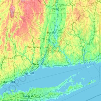
Nom : Carte topographique Connecticut, altitude, relief.
Lieu : Connecticut, United States (40.95098 -73.72781 42.05058 -71.78724)
Altitude moyenne : 118 m
Altitude minimum : -3 m
Altitude maximum : 780 m
Winters (December through mid-March) are generally cold from south to north in Connecticut. The coldest month (January) has average high temperatures ranging from 38 °F (3 °C) in the coastal lowlands to 33 °F (1 °C) in the inland and northern portions on the state. The lowest temperature recorded in Connecticut is −32 °F (−36 °C) which has been observed twice: in Falls Village on February 16, 1943, and in Coventry on January 22, 1961. The average yearly snowfall ranges from about 60 inches (1,500 mm) in the higher elevations of the northern portion of the state to only 20–25 inches (510–640 mm) along the southeast coast of Connecticut (Branford to Groton). Generally, any locale north or west of Interstate 84 receives the most snow, during a storm, and throughout the season. Most of Connecticut has less than 60 days of snow cover. Snow usually falls from late November to late March in the northern part of the state, and from early December to mid-March in the southern and coastal parts of the state.
Autres cartes topographiques
Cliquez sur une carte pour visualiser sa topographie, son altitude et son relief.
Brooklyn
United States > New York > New York
Brooklyn, Kings County, New York, United States
Altitude moyenne : 9 m
Houston
United States > Texas > Harris County
Houston, Harris County, Texas, United States
Altitude moyenne : 25 m
Jacksonville
United States > Florida > Duval County
Jacksonville, Duval County, Florida, United States
Altitude moyenne : 10 m
Santa Cruz
United States > California > Santa Cruz County
Santa Cruz, Santa Cruz County, California, United States
Altitude moyenne : 89 m
Aurora
United States > Colorado > Adams County
Aurora, Adams County, Colorado, United States
Altitude moyenne : 1’691 m
Hillsborough County
Hillsborough County, Florida, United States
Altitude moyenne : 20 m
Albuquerque
United States > New Mexico > Bernalillo County
Albuquerque, Bernalillo County, New Mexico, United States
Altitude moyenne : 1’688 m
Santa Barbara
United States > California > Santa Barbara County
Santa Barbara, Santa Barbara County, California, United States
Altitude moyenne : 119 m
Parker
United States > Colorado > Douglas County
Parker, Douglas County, Colorado, 80134, United States
Altitude moyenne : 1’845 m
Cape Cod
United States > Massachusetts > Plymouth County
Cape Cod, Plymouth County, Massachusetts, United States
Altitude moyenne : 2 m
Manhattan
United States > New York > New York County > New York
Manhattan, New York County, New York, United States
Altitude moyenne : 16 m
Spokane
United States > Washington > Spokane County
Spokane, Spokane County, Washington, United States
Altitude moyenne : 655 m
Whatcom County
Whatcom County, Washington, United States
Altitude moyenne : 753 m
Indianapolis
United States > Indiana > Indianapolis
Indianapolis, Marion County, Indiana, 46204, United States
Altitude moyenne : 241 m
San Mateo County
San Mateo County, California, United States
Altitude moyenne : 109 m
Provo
United States > Utah > Utah County
Provo, Utah County, Utah, United States
Altitude moyenne : 1’728 m
Boulder
United States > Colorado > Boulder County
Boulder, Boulder County, Colorado, United States
Altitude moyenne : 1’785 m