
Carte topographique Utah
Carte interactive
Cliquez sur la carte pour afficher l’altitude.
À propos de cette carte
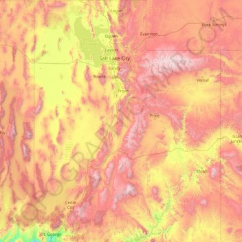
Nom : Carte topographique Utah, altitude, relief.
Lieu : Utah, United States (36.99781 -114.05285 42.00170 -109.04158)
Altitude moyenne : 1’876 m
Altitude minimum : 789 m
Altitude maximum : 3’986 m
Western Utah is mostly arid desert with a basin and range topography. Small mountain ranges and rugged terrain punctuate the landscape. The Bonneville Salt Flats are an exception, being comparatively flat as a result of once forming the bed of ancient Lake Bonneville. Great Salt Lake, Utah Lake, Sevier Lake, and Rush Lake are all remnants of this ancient freshwater lake, which once covered most of the eastern Great Basin. West of the Great Salt Lake, stretching to the Nevada border, lies the arid Great Salt Lake Desert. One exception to this aridity is Snake Valley, which is (relatively) lush due to large springs and wetlands fed from groundwater derived from snow melt in the Snake Range, Deep Creek Range, and other tall mountains to the west of Snake Valley. Great Basin National Park is just over the Nevada state line in the southern Snake Range. One of western Utah's most impressive, but least visited attractions is Notch Peak, the tallest limestone cliff in North America, located west of Delta.
Autres cartes topographiques
Cliquez sur une carte pour visualiser sa topographie, son altitude et son relief.
Brooklyn
United States > New York > New York
Brooklyn, Kings County, New York, United States
Altitude moyenne : 9 m
Houston
United States > Texas > Harris County
Houston, Harris County, Texas, United States
Altitude moyenne : 25 m
Jacksonville
United States > Florida > Duval County
Jacksonville, Duval County, Florida, United States
Altitude moyenne : 10 m
Santa Cruz
United States > California > Santa Cruz County
Santa Cruz, Santa Cruz County, California, United States
Altitude moyenne : 89 m
Aurora
United States > Colorado > Adams County
Aurora, Adams County, Colorado, United States
Altitude moyenne : 1’691 m
Hillsborough County
Hillsborough County, Florida, United States
Altitude moyenne : 20 m
Albuquerque
United States > New Mexico > Bernalillo County
Albuquerque, Bernalillo County, New Mexico, United States
Altitude moyenne : 1’688 m
Santa Barbara
United States > California > Santa Barbara County
Santa Barbara, Santa Barbara County, California, United States
Altitude moyenne : 119 m
Parker
United States > Colorado > Douglas County
Parker, Douglas County, Colorado, 80134, United States
Altitude moyenne : 1’845 m
Cape Cod
United States > Massachusetts > Plymouth County
Cape Cod, Plymouth County, Massachusetts, United States
Altitude moyenne : 2 m
Manhattan
United States > New York > New York County > New York
Manhattan, New York County, New York, United States
Altitude moyenne : 16 m
Spokane
United States > Washington > Spokane County
Spokane, Spokane County, Washington, United States
Altitude moyenne : 655 m
Whatcom County
Whatcom County, Washington, United States
Altitude moyenne : 753 m
Indianapolis
United States > Indiana > Indianapolis
Indianapolis, Marion County, Indiana, 46204, United States
Altitude moyenne : 241 m
San Mateo County
San Mateo County, California, United States
Altitude moyenne : 109 m
Provo
United States > Utah > Utah County
Provo, Utah County, Utah, United States
Altitude moyenne : 1’728 m