
Carte topographique Kirtipur
Carte interactive
Cliquez sur la carte pour afficher l’altitude.
À propos de cette carte
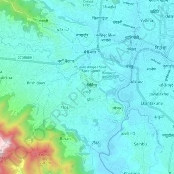
Nom : Carte topographique Kirtipur, altitude, relief.
Lieu : Kirtipur, Kathmandu, Bagmati Pradesh, 44618, Nepal (27.63666 85.23824 27.71666 85.31824)
Altitude moyenne : 1’414 m
Altitude minimum : 1’258 m
Altitude maximum : 2’487 m
Autres cartes topographiques
Cliquez sur une carte pour visualiser sa topographie, son altitude et son relief.