Géolocaliser

Carte topographique Tokha

Carte interactive

Cliquez sur la carte pour afficher l’altitude.

À propos de cette carte

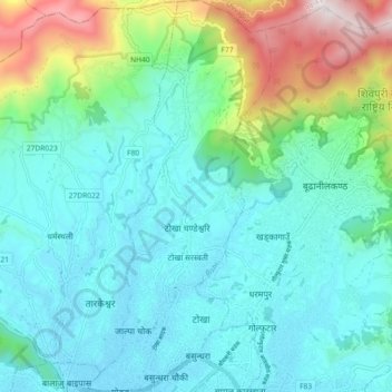
Nom : Carte topographique Tokha, altitude, relief.

Lieu : Tokha, Kathmandu, Bagmati Pradesh, Nepal (27.73491 85.30718 27.81536 85.34952)

Altitude moyenne : 1’547 m

Altitude minimum : 1’301 m

Altitude maximum : 2’438 m

Autres cartes topographiques

Cliquez sur une carte pour visualiser sa topographie, son altitude et son relief.

Namgyal

Nepal > Kathmandu

Namgyal, Gokarneshwar Municipality, Kathmandu, 46603, Nepal

Altitude moyenne : 1’366 m

Kathmandu

Nepal > Kathmandu

Kathmandu, Bagmati Pradesh, Nepal

Altitude moyenne : 1’335 m

Kirtipur

Nepal > Kathmandu

Kirtipur, Kathmandu, Bagmati Pradesh, 44618, Nepal

Altitude moyenne : 1’380 m

Kirtipur

Nepal > Kathmandu

Kirtipur, Kathmandu, Bagmati Pradesh, 44618, Nepal

Altitude moyenne : 1’414 m