
Carte topographique Uttar Dinajpur
Carte interactive
Cliquez sur la carte pour afficher l’altitude.
À propos de cette carte
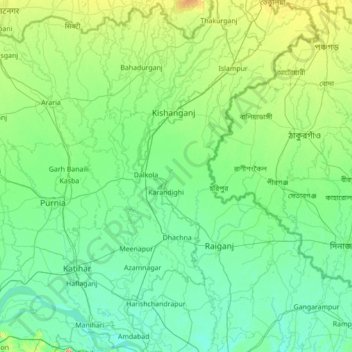
Nom : Carte topographique Uttar Dinajpur, altitude, relief.
Lieu : Uttar Dinajpur, West Bengal, India (25.24501 87.80975 26.49669 88.52506)
Altitude moyenne : 45 m
Altitude minimum : 20 m
Altitude maximum : 211 m
The regional topography is generally flat with a gentle southerly slope towards which the main rivers like Kulik, Nagar, Mahananda. The District forms a part of the basin lying between Rajmahal hills on the east. The older alluvium is estimated to be Pleistocene age. Uttar Dinajpur is bestowed with a very fertile soil. The soil is very rich in nature due to the alluvial deposition which helps to grow Paddy, Jute, Mesta and Sugarcane etc. Raiganj on the banks of the River Kulik is the District Headquarters where the "Raiganj Wildlife Sanctuary", the second largest bird sanctuary in Asia, is situated. In Uttar Dinajpur district, there are 2 sub-divisions, Raiganj and Islampur, 110 km (68 mi) apart from each other. There are 4 Municipalities, 9 Blocks and 99 Panchayats covering 1577 villages. The total population is nearly 25 lakh (2.5 million), consisting mainly of rural masses. Bengali is the main language but a sizeable number of Urdu, Hindi and Maithili speaking people live in Islampur sub-division. It is one of the most backward districts of India educationally and economically owing to state neglect. The major native dialect is called locally Surjapuri or Rajbanshi (or even Dinajpuri).
Autres cartes topographiques
Cliquez sur une carte pour visualiser sa topographie, son altitude et son relief.
Siliguri
India > West Bengal > Siliguri Subdivsion
Siliguri, Siliguri Subdivsion, Darjeeling District, West Bengal, India
Altitude moyenne : 121 m
Bangaon
India > West Bengal > Bongaon
Bangaon, Bongaon, North 24 Parganas District, West Bengal, 743235, India
Altitude moyenne : 7 m
Darjeeling district
Darjeeling district, West Bengal, India
Altitude moyenne : 728 m
Taki
India > West Bengal > Hasnabad
Taki, Hasnabad, North 24 Parganas District, West Bengal, 743429, India
Altitude moyenne : 4 m
Thakurpukur Maheshtala
Thakurpukur Maheshtala, South 24 Parganas District, West Bengal, India
Altitude moyenne : 5 m
Rajganj
India > West Bengal > Rajganj
Rajganj, Jalpaiguri District, West Bengal, 735134, India
Altitude moyenne : 93 m
Swabhumi
India > West Bengal > Kolkata
Swabhumi, Kolkata, Kolkata District, West Bengal, India
Altitude moyenne : 6 m
Kolkata
Kolkata, Kolkata District, West Bengal, 700073, India
Altitude moyenne : 5 m
Mathurapur - I
Mathurapur - I, South 24 Parganas District, West Bengal, 743354, India
Altitude moyenne : 4 m
Bidhannagar
Bidhannagar, North 24 Parganas District, West Bengal, India
Altitude moyenne : 5 m
Bhangar - I
Bhangar - I, South 24 Parganas District, West Bengal, 743502, India
Altitude moyenne : 3 m
Bolpur
India > West Bengal > Bolpur Sriniketan
Bolpur, Bolpur Sriniketan, Birbhum District, West Bengal, India
Altitude moyenne : 50 m
West Dinājpur
West Dinājpur, Dakshin Dinajpur District, West Bengal, India
Altitude moyenne : 34 m
Medinipur
India > West Bengal > Midnapore
Medinipur, Midnapore, Paschim Medinipur District, West Bengal, 721101, India
Altitude moyenne : 39 m
Rampurhat
India > West Bengal > Rampurhat - I
Rampurhat, Rampurhat - I, Birbhum District, West Bengal, 731224, India
Altitude moyenne : 38 m
Gangapur
India > West Bengal > Barasat - I
Gangapur, Barasat - I, North 24 Parganas District, West Bengal, 743248, India
Altitude moyenne : 7 m
Baranagar
India > West Bengal > Barrackpore
Baranagar, Barrackpore, North 24 Parganas District, West Bengal, 700035, India
Altitude moyenne : 6 m
Asansol Kulti Township
Asansol Kulti Township, Paschim Bardhaman District, West Bengal, India
Altitude moyenne : 125 m
Kolkata
Kolkata, Kolkata District, West Bengal, India, Adi Ganga
Altitude moyenne : 8 m
Raiganj
Raiganj, Uttar Dinajpur District, West Bengal, India
Altitude moyenne : 35 m
B-13
India > West Bengal > Kalyani
B-13, Kalyani, Nadia District, West Bengal, India
Altitude moyenne : 10 m
Kharagpur
India > West Bengal > Kharagpur-I
Kharagpur, Kharagpur-I, Paschim Medinipur District, West Bengal, 721301, India
Altitude moyenne : 39 m
North Dumdum
India > West Bengal > Barrackpore
North Dumdum, Barrackpore, North 24 Parganas District, West Bengal, 700051, India
Altitude moyenne : 7 m
Garbeta-III
Garbeta-III, Paschim Medinipur District, West Bengal, 721253, India
Altitude moyenne : 42 m
South 24 Parganas District
South 24 Parganas District, West Bengal, India
Altitude moyenne : 3 m
Kangsabati Reservoir
India > West Bengal > Ranibundh
Kangsabati Reservoir, Ranibundh, Bankura District, West Bengal, India
Altitude moyenne : 136 m
Ghatal
Ghatal, Paschim Medinipur District, West Bengal, India
Altitude moyenne : 11 m
Malda
India > West Bengal > English Bazar
Malda, English Bazar, Maldah, West Bengal, 732101, India
Altitude moyenne : 26 m
Tufanganj - I
Tufanganj - I, Cooch Behar District, West Bengal, India
Altitude moyenne : 37 m
Dum Dum
India > West Bengal > Barrackpore
Dum Dum, Barrackpore, North 24 Parganas District, West Bengal, 700081, India
Altitude moyenne : 6 m
Darjeeling Pulbazar
Darjeeling Pulbazar, Darjeeling District, West Bengal, India
Altitude moyenne : 1’779 m
Chandipur
Chandipur, Purba Medinipur District, West Bengal, 721659, India
Altitude moyenne : 4 m
Digha
India > West Bengal > Digha
Digha, Ramnagar-I, Purba Medinipur, West Bengal, 721428, India
Altitude moyenne : 4 m
Shiulibari
India > West Bengal > Contai-III
Shiulibari, Contai-III, Purba Medinipur District, West Bengal, 721449, India
Altitude moyenne : 4 m
Bikna
India > West Bengal > Bankura - II
Bikna, Bankura - II, Bankura District, West Bengal, 722180, India
Altitude moyenne : 85 m
Bishnupur - II
Bishnupur - II, South 24 Parganas District, West Bengal, 743377, India
Altitude moyenne : 4 m
Diamond Harbour - II
Diamond Harbour - II, South 24 Parganas, West Bengal, 743368, India
Altitude moyenne : 3 m
Bhangar - II
Bhangar - II, South 24 Parganas, West Bengal, India
Altitude moyenne : 4 m
Krishnanagar
India > West Bengal > Krishnagar-I > Krishnanagar
Krishnanagar, Krishnagar-I, Nadia, West Bengal, 741101, India
Altitude moyenne : 11 m
Sevoke
India > West Bengal > Sevoke
Sevoke, Darjiling, Darjeeling, West Bengal, India
Altitude moyenne : 254 m
Cooch Behar
India > West Bengal > Cooch Behar
Cooch Behar, Koch Bihār, Kochbihar, West Bengal, 736101, India
Altitude moyenne : 43 m
Sagar Island
Sagar Island, Sagar, South 24 Parganas, West Bengal, 743606, India
Altitude moyenne : 2 m
Damdim
India > West Bengal > Mal
Damdim, Mal, Jalpaiguri District, West Bengal, 735209, India
Altitude moyenne : 161 m