
Carte topographique Malda
Cliquez sur la carte pour afficher l’altitude.
Malda
Malda is located at 25°00′43″N 88°08′36″E / 25.0119°N 88.1433°E / 25.0119; 88.1433. It has an average elevation of 17 metres (56 feet). It is situated on both the western and eastern banks of the river Mahananda.
À propos de cette carte
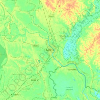
Nom : Carte topographique Malda, altitude, relief.
Lieu : Malda, English Bazar, Maldah, West Bengal, 732101, India (24.84574 87.97985 25.16574 88.29985)
Altitude moyenne : 26 m
Altitude minimum : 13 m
Altitude maximum : 51 m