
Carte topographique Hüttenrode
Carte interactive
Cliquez sur la carte pour afficher l’altitude.
À propos de cette carte
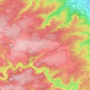
Nom : Carte topographique Hüttenrode, altitude, relief.
Altitude moyenne : 436 m
Altitude minimum : 218 m
Altitude maximum : 535 m
Autres cartes topographiques
Cliquez sur une carte pour visualiser sa topographie, son altitude et son relief.
Börnecke
Deutschland > Sachsen-Anhalt > Landkreis Harz > Blankenburg
Börnecke, Blankenburg, Landkreis Harz, Sachsen-Anhalt, Deutschland
Altitude moyenne : 170 m
Teufelsmauer
Deutschland > Sachsen-Anhalt > Landkreis Harz > Blankenburg
Teufelsmauer, Blankenburg, Landkreis Harz, Sachsen-Anhalt, 38889, Deutschland
Altitude moyenne : 225 m
Timmenrode
Deutschland > Sachsen-Anhalt > Landkreis Harz > Blankenburg
Timmenrode, Blankenburg, Landkreis Harz, Sachsen-Anhalt, Deutschland
Altitude moyenne : 191 m
Börnecke
Deutschland > Sachsen-Anhalt > Landkreis Harz > Blankenburg
Börnecke, Blankenburg, Landkreis Harz, Sachsen-Anhalt, Deutschland
Altitude moyenne : 176 m
Ziegenkopf
Deutschland > Sachsen-Anhalt > Landkreis Harz > Blankenburg
Ziegenkopf, Blankenburg, Landkreis Harz, Sachsen-Anhalt, 38889, Deutschland
Altitude moyenne : 331 m
Volkmarskeller
Deutschland > Sachsen-Anhalt > Landkreis Harz > Blankenburg
Volkmarskeller, Heimburg, Blankenburg, Landkreis Harz, Sachsen-Anhalt, 38889, Deutschland
Altitude moyenne : 460 m
Blankenstein
Deutschland > Sachsen-Anhalt > Landkreis Harz > Blankenburg
Blankenstein, Blankenburg, Landkreis Harz, Sachsen-Anhalt, 38889, Deutschland
Altitude moyenne : 267 m
Heimburg
Deutschland > Sachsen-Anhalt > Landkreis Harz > Blankenburg
Heimburg, Blankenburg, Landkreis Harz, Sachsen-Anhalt, Deutschland
Altitude moyenne : 301 m