
Faire un don
Équipez-vous pour votre prochaine aventure :
En tant que Partenaire Amazon, ce site perçoit une commission sur les achats éligibles sans surcoût pour vous.
Carte topographique Timmenrode
Cliquez sur la carte pour afficher l’altitude.
Faire un don
Équipez-vous pour votre prochaine aventure :
En tant que Partenaire Amazon, ce site perçoit une commission sur les achats éligibles sans surcoût pour vous.
À propos de cette carte
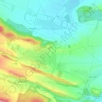
Nom : Carte topographique Timmenrode, altitude, relief.
Altitude moyenne : 191 m
Altitude minimum : 148 m
Altitude maximum : 279 m
Faire un don
Équipez-vous pour votre prochaine aventure :
En tant que Partenaire Amazon, ce site perçoit une commission sur les achats éligibles sans surcoût pour vous.
Autres cartes topographiques
Cliquez sur une carte pour visualiser sa topographie, son altitude et son relief.
Faire un don
Équipez-vous pour votre prochaine aventure :
En tant que Partenaire Amazon, ce site perçoit une commission sur les achats éligibles sans surcoût pour vous.
Ziegenkopf
Deutschland > Sachsen-Anhalt > Landkreis Harz > Blankenburg
Vor über 100 Jahren wurde auf der Bergkuppe des Ziegenkopfs der steinerne und im oberen Teil mit Holz verkleidete Aussichtsturm Ziegenkopfturm mit 30 m Höhe errichtet, der eine gute Rundumsicht bis hin zum Brocken bietet. Direkt an den Turm angegliedert ist der Berggasthof Ziegenkopf.
Altitude moyenne : 331 m