
Faire un don
Équipez-vous pour votre prochaine aventure :
En tant que Partenaire Amazon, ce site perçoit une commission sur les achats éligibles sans surcoût pour vous.
Carte topographique Börnecke
Cliquez sur la carte pour afficher l’altitude.
Faire un don
Équipez-vous pour votre prochaine aventure :
En tant que Partenaire Amazon, ce site perçoit une commission sur les achats éligibles sans surcoût pour vous.
À propos de cette carte
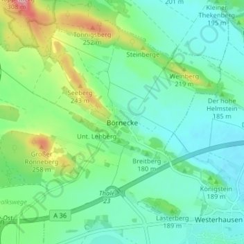
Nom : Carte topographique Börnecke, altitude, relief.
Altitude moyenne : 170 m
Altitude minimum : 132 m
Altitude maximum : 276 m
Faire un don
Équipez-vous pour votre prochaine aventure :
En tant que Partenaire Amazon, ce site perçoit une commission sur les achats éligibles sans surcoût pour vous.
Autres cartes topographiques
Cliquez sur une carte pour visualiser sa topographie, son altitude et son relief.
Heimburg
Deutschland > Sachsen-Anhalt > Landkreis Harz > Blankenburg
Unmittelbar nördlich des Dorfs liegt eine Anhöhe, auf der sich die Überreste der ehemaligen Burg Heimburg, auch Altenburg genannt, und ein Aussichtspunkt befinden. Zudem liegt Heimburg am Fuß der Hügelkette von Ziegenberg (315,7 m) und Struvenberg (305,7 m), die sich in Richtung Nordwesten bis…
Altitude moyenne : 301 m
Faire un don
Équipez-vous pour votre prochaine aventure :
En tant que Partenaire Amazon, ce site perçoit une commission sur les achats éligibles sans surcoût pour vous.
Börnecke
Deutschland > Sachsen-Anhalt > Landkreis Harz > Blankenburg
Börnecke liegt etwa sechs Kilometer nordöstlich des Stadtzentrums von Blankenburg. Etwa acht Kilometer nördlich befindet sich die Kreisstadt des Landkreises Harz, Halberstadt, etwa neun Kilometer südöstlich die Weltkulturerbestadt Quedlinburg und etwa acht Kilometer südlich die Stadt Thale. Das Dorf ist…
Altitude moyenne : 176 m
Faire un don
Équipez-vous pour votre prochaine aventure :
En tant que Partenaire Amazon, ce site perçoit une commission sur les achats éligibles sans surcoût pour vous.