Géolocaliser

Carte topographique Torfaen

Cliquez sur la carte pour afficher l’altitude.

Torfaen

Exterior A large iron framed market hall with two full elevations and three secondary entrances through other street frontages, eg. Jubilee Building, Crane Street. Built of grey narrow coursed rock faced pennant limestone with some larger stones, and with yellow Ebbw Vale brick dressings and a Welsh slate roof. Single storey street elevations with windows onto secondary aisles which surround the main aisled hall. The Market Street elevation has a central doorway with four centred Tudor arch head. This has part glazed wooden doors with pilasters rising to a corbel frieze and a date panel 1893, and a parapet over with raised battlement type features at either end. This door is flanked on either side by four three-light windows with yellow brick frames and mullions. These are all in line, but the plinth below with yellow brick coping is stepped down the street. Additional doors flank these, again with pilasters but not rising to a parapet; then another three light window at the north end but only a single light one at the south corner. The end elevation has first a single light, then a two-light with king mullion, then five three-light windows, the most northerly one with a roundel in a gable above. The roofs behind these walls can be seen stepped up in three heights over the two aisles and the main nave. The nave roof has timber gable windows and glazing along the length of the roof on both slopes. Crane Street entrance: This has another Tudor doorway as above, but flanked by one over one windows in plain heads. Above the entrance is a crow-stepped gable with block at apex and a three light window with stepped head above the door. Gable has date 1894 and inscription PLB (Pontypool Local Board). Commercial Street entrance has another Tudor style doorway set into the ground floor of an early C19 terrace on the south west side of Commercial Street. Only the doorway and the dateplaque 1894 above it are late C19.

Wikipedia (CC-BY-SA 3.0)

À propos de cette carte

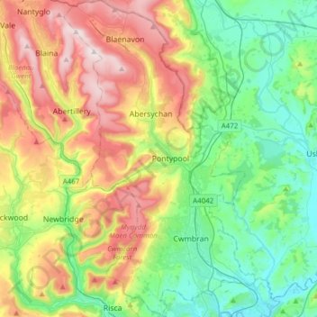
Nom : Carte topographique Torfaen, altitude, relief.

Lieu : Torfaen, Wales, United Kingdom (51.60667 -3.14392 51.79623 -2.95882)

Altitude moyenne : 206 m

Altitude minimum : 0 m

Altitude maximum : 575 m

Autres cartes topographiques

Cliquez sur une carte pour visualiser sa topographie, son altitude et son relief.

Swansea

United Kingdom > Wales > Swansea

Much of Swansea is hilly with the main area of upland being located in the council ward of Mawr. Areas up to 185 metres (607 ft) in elevation range across the central section: Kilvey Hill, Townhill and Llwynmawr separate the centre of Swansea from its northern suburbs. Cefn Bryn, a ridge of high land, is the…

Altitude moyenne : 73 m

Cardiff

United Kingdom > Wales > Cardiff

Altitude moyenne : 55 m

Snowdon

United Kingdom > Wales > Gwynedd

Snowdon (/ˈsnoʊdən/) or Yr Wyddfa (pronounced [ər ˈʊɨ̞̯ðva] (listen)), is the highest mountain in Wales, at an elevation of 1,085 metres (3,560 ft) above sea level, and the highest point in the British Isles outside the Scottish Highlands. It is located in Snowdonia National Park (Parc Cenedlaethol…

Altitude moyenne : 692 m

Llandudno

United Kingdom > Wales > Conwy

Altitude moyenne : 19 m

Llanfyllin

United Kingdom > Wales > Powys

Altitude moyenne : 219 m

Bute Park

United Kingdom > Wales > Cardiff > Cardiff

Altitude moyenne : 14 m

Tondu

United Kingdom > Wales > Bridgend County Borough

Altitude moyenne : 99 m

Blaenau Ffestiniog

United Kingdom > Wales > Gwynedd

Altitude moyenne : 379 m

Aberdare

United Kingdom > Wales > Rhondda Cynon Taf

Altitude moyenne : 275 m

Llanberis

United Kingdom > Wales > Gwynedd

Altitude moyenne : 322 m

Tanyfron

United Kingdom > Wales > Wrexham

Altitude moyenne : 178 m

Whitland

United Kingdom > Wales > Carmarthenshire > Whitland

Altitude moyenne : 43 m

Rhossili

United Kingdom > Wales > Swansea

Altitude moyenne : 41 m

Sennybridge

United Kingdom > Wales > Powys

Altitude moyenne : 261 m

Ffos-y-ffin

United Kingdom > Wales > Ceredigion

Ffos-y-ffin is a linear roadside village in the county of Ceredigion, west Wales, straddling the A487 3 km south-west of Aberaeron at National Grid reference SN 446,600. The Welsh Language Commissioner records the standard form as Ffos-y-ffin—literally 'boundary ditch'—a topographical allusion to an early…

Altitude moyenne : 93 m

Llanelli

United Kingdom > Wales > Carmarthenshire

Altitude moyenne : 41 m

Foel Penolau

United Kingdom > Wales

Altitude moyenne : 423 m

Ysgafell Wen

United Kingdom > Wales

Altitude moyenne : 517 m

Moel Yr Hydd

United Kingdom > Wales

Altitude moyenne : 429 m

Taff

United Kingdom > Wales

Altitude moyenne : 270 m

Fron Goch

United Kingdom > Wales

Altitude moyenne : 196 m

Yr Eifl

United Kingdom > Wales

Altitude moyenne : 257 m

Mynydd Carningli

United Kingdom > Wales

Altitude moyenne : 213 m

Dudwell Mountain

United Kingdom > Wales

Altitude moyenne : 118 m

Penhros Coppice

United Kingdom > Wales

Altitude moyenne : 107 m

Cefn Coch

United Kingdom > Wales

Altitude moyenne : 328 m

Cefn Coch

United Kingdom > Wales

Altitude moyenne : 458 m

Llangammarch Wells

United Kingdom > Wales > Powys

Altitude moyenne : 239 m

Gwynedd

United Kingdom > Wales

Altitude moyenne : 332 m

Powys

United Kingdom > Wales

Altitude moyenne : 285 m

Isle of Anglesey

United Kingdom > Wales

Altitude moyenne : 65 m

Abercynon

United Kingdom > Wales > Rhondda Cynon Taf

Altitude moyenne : 210 m

Llangennech

United Kingdom > Wales > Carmarthenshire

Altitude moyenne : 37 m

Bullwell Bay

United Kingdom > Wales

Altitude moyenne : 14 m

Tremadog Bay

United Kingdom > Wales

Altitude moyenne : 0 m

Newport

United Kingdom > Wales > Newport

Altitude moyenne : 89 m

Tywyn

United Kingdom > Wales > Gwynedd

In Samuel Lewis's A Topographical Dictionary of Wales (1833) it is reported that popular horse races were held on land to the north of the town every September. Between 1904 and 1947, Towyn Golf Club (originally the Towyn-on-Sea Golf Club) was also located on land to the north of the town.

Altitude moyenne : 50 m

River Taff

United Kingdom > Wales > Cardiff > Cardiff

Altitude moyenne : 20 m

Gwent

United Kingdom > Wales > Monmouthshire

Altitude moyenne : 83 m

Neath

United Kingdom > Wales > Neath Port Talbot

Altitude moyenne : 115 m

Llwyndafydd

United Kingdom > Wales > Ceredigion

Altitude moyenne : 148 m

Harlech

United Kingdom > Wales > Gwynedd

Altitude moyenne : 68 m

Bwlch

United Kingdom > Wales > Powys

Altitude moyenne : 196 m

Cribyn

United Kingdom > Wales > Ceredigion

Altitude moyenne : 196 m

Craigiau Rhaeadr Fawr

United Kingdom > Wales > Gwynedd

Altitude moyenne : 411 m

Pantymwyn

United Kingdom > Wales > Flintshire

Altitude moyenne : 213 m

Borth

United Kingdom > Wales > Ceredigion

Altitude moyenne : 28 m

Mathern

United Kingdom > Wales > Monmouthshire

Altitude moyenne : 27 m

Bangor

United Kingdom > Wales > Bangor

Altitude moyenne : 149 m

Wrexham

United Kingdom > Wales > Wrexham

Altitude moyenne : 139 m

Pontardawe

United Kingdom > Wales > Neath Port Talbot

Altitude moyenne : 161 m

Trawsfynydd

United Kingdom > Wales > Gwynedd

Altitude moyenne : 234 m

Aberystwyth

United Kingdom > Wales > Ceredigion

Aberystwyth experiences an oceanic climate (Köppen climate classification Cfb) similar to almost all of the United Kingdom. This is particularly pronounced due to its west coast location facing the Irish Sea. Air undergoes little land moderation and so temperatures closely reflect the sea temperature when…

Altitude moyenne : 39 m

Abergavenny

United Kingdom > Wales > Monmouthshire

Altitude moyenne : 187 m

Caerleon

United Kingdom > Wales > Gwent > Newport > Caerleon

Altitude moyenne : 37 m

Brecon

United Kingdom > Wales > Powys

Altitude moyenne : 216 m

Builth Wells

United Kingdom > Wales > Powys

Altitude moyenne : 232 m

Crickhowell

United Kingdom > Wales > Powys

Altitude moyenne : 253 m

Llandrindod Wells

United Kingdom > Wales > Powys

Altitude moyenne : 247 m

Llanddewi

United Kingdom > Wales > Swansea

Altitude moyenne : 63 m

Banc Y Garth

United Kingdom > Wales > Carmarthenshire

Altitude moyenne : 342 m

Ton-Mawr

United Kingdom > Wales > Neath Port Talbot

Altitude moyenne : 222 m

Beulah

United Kingdom > Wales > Powys

Altitude moyenne : 239 m

Beulah

United Kingdom > Wales > Ceredigion

Altitude moyenne : 139 m

Colwyn Bay

United Kingdom > Wales > Conwy

Altitude moyenne : 68 m

Grosmont

United Kingdom > Wales > Monmouthshire

Altitude moyenne : 128 m

New Brighton

United Kingdom > Wales > Flintshire

Altitude moyenne : 131 m

Markham

United Kingdom > Wales > Caerphilly County Borough

Altitude moyenne : 281 m

Bethlehem

United Kingdom > Wales > Carmarthenshire

Altitude moyenne : 115 m

Murton

United Kingdom > Wales > Swansea

Altitude moyenne : 66 m

Abermorddu

United Kingdom > Wales > Flintshire

Altitude moyenne : 124 m

Abergynolwyn

United Kingdom > Wales > Gwynedd

Altitude moyenne : 187 m

Brynithel

United Kingdom > Wales > Blaenau Gwent

Altitude moyenne : 288 m

Rhosgoch

United Kingdom > Wales > Powys

Altitude moyenne : 311 m

Rhinog Fawr

United Kingdom > Wales > Gwynedd

Altitude moyenne : 434 m

Llangattock

United Kingdom > Wales > Powys

Altitude moyenne : 166 m

Llanfilo

United Kingdom > Wales > Powys

Altitude moyenne : 187 m

Oxwich

United Kingdom > Wales > Swansea

Altitude moyenne : 36 m

Nicholaston

United Kingdom > Wales > Swansea

Altitude moyenne : 53 m

Abersychan

United Kingdom > Wales > Torfaen

Altitude moyenne : 299 m

Penpedairheol

United Kingdom > Wales > Monmouthshire > Monkswood

Altitude moyenne : 74 m

Ynystawe

United Kingdom > Wales > Swansea

Altitude moyenne : 63 m

Ynysmeudwy

United Kingdom > Wales > Neath Port Talbot

Altitude moyenne : 126 m

Burgedin

United Kingdom > Wales > Powys > Sarnau

Altitude moyenne : 90 m

Wolf's Castle

United Kingdom > Wales > Pembrokeshire

Altitude moyenne : 87 m

Cwmtydu

United Kingdom > Wales > Ceredigion

Altitude moyenne : 67 m

Prestatyn

United Kingdom > Wales > Denbighshire

Altitude moyenne : 48 m

Evenjobb

United Kingdom > Wales > Powys

Altitude moyenne : 236 m

Tanypistyll

United Kingdom > Wales > Powys

Altitude moyenne : 511 m

Ysbyty Ystwyth

United Kingdom > Wales > Ceredigion

Altitude moyenne : 259 m

Rock

United Kingdom > Wales > Neath Port Talbot > Pont-rhyd-y-fen

Altitude moyenne : 166 m

Freystrop Cross

United Kingdom > Wales > Pembrokeshire

Altitude moyenne : 53 m

Ponthir

United Kingdom > Wales > Torfaen > Newport

Altitude moyenne : 41 m

Nantyglo

United Kingdom > Wales > Blaenau Gwent

Altitude moyenne : 398 m

Felindre

United Kingdom > Wales > Powys

Altitude moyenne : 203 m

Équipez-vous pour votre prochaine aventure :

📷Appareil photo de sport - Capturez vos exploits même sous la pluie ou dans la neige
🧴Répulsifs anti-insectes - Protection contre moustiques et tiques
🔋Piles rechargeables - Économiques et écologiques pour vos appareils nomades
🧭Boussole de précision - Idéale pour l'orientation avec cartes topographiques en milieu alpin
🧺Couverture de survie - Équipement de sécurité vital pour prévenir l'hypothermie

En tant que Partenaire Amazon, ce site perçoit une commission sur les achats éligibles sans surcoût pour vous.