
Carte topographique St Davids
Carte interactive
Cliquez sur la carte pour afficher l’altitude.
À propos de cette carte
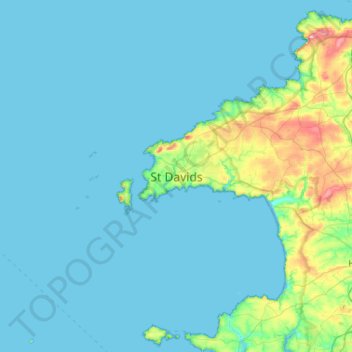
Nom : Carte topographique St Davids, altitude, relief.
Lieu : St Davids, Pembrokeshire, Wales, SA62 6SE, United Kingdom (51.72106 -5.42585 52.04106 -5.10585)
Altitude moyenne : 22 m
Altitude minimum : 0 m
Altitude maximum : 203 m
Autres cartes topographiques
Cliquez sur une carte pour visualiser sa topographie, son altitude et son relief.
Preseli Mountains
United Kingdom > Wales > Pembrokeshire > Puncheston
Samuel Lewis's A Topographical Dictionary of Wales published in 1833 said of Maenclochog parish.
Altitude moyenne : 217 m
Milford Haven
United Kingdom > Wales > Pembrokeshire
One of the earliest notable figures from the Milford Haven area is Howell Davis, a pirate born in 1680. He was shot dead in 1719 on the Portuguese island of Príncipe. Other famous residents connected as seafarers include Isaac Davis, a former seaman who was engaged in the fur trade between the Pacific…
Altitude moyenne : 36 m
Puncheston
United Kingdom > Wales > Pembrokeshire > Puncheston
A map of 1578 shows the parish as Castle Male, presumably a phonetic spelling of the Welsh name by the English mapmaker. Lewis's Topographical Dictionary of 1844 gives 326 inhabitants (the 1849 edition gives 255) for the parish, which includes the village and a number of outlying residences and farms. Lewis…
Altitude moyenne : 165 m